Cold winds Wednesday; temps rebound Thursday; snow possible late Friday

Waves of cold, milder drive roller coaster temps the weekend

MSP temps
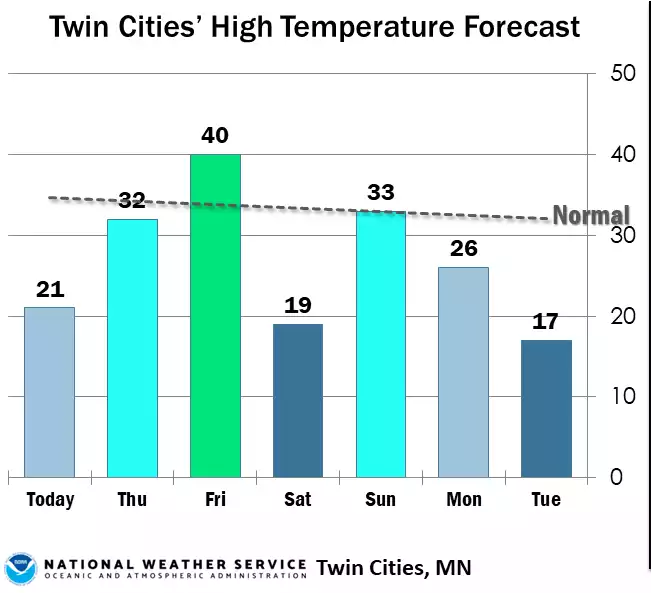
Forecast up and down high temperatures for the Twin cities the next several days
National Weather Service

Gusty winds from the northwest are blowing at 15 to 40 mph across much of Minnesota Wednesday. Temperatures will remain in the teens to low 20s for most with wind chill values in the single digits above zero in the east and subzero west.

After a cold night, Thursday will be much warmer in the 30s and 20s with highs near 40 in southern Minnesota Friday. The next chance of snow moves in late Friday also into Friday night.

Windy, cold Wednesday, then temps rebound

The winds are definitely blowing around the fresh snow Wednesday. Sustained wind speeds will remain between 10 and 25 mph with gusts as high as 45 mph.

winds WED loop
Forecast wind gusts Wednesday
College of DuPage weather lab

High temperatures Wednesday will not budge much with the colder air mass moving in and fresh snow reflecting back the sunlight.

Create a More Connected Minnesota

MPR News is your trusted resource for the news you need. With your support, MPR News brings accessible, courageous journalism and authentic conversation to everyone - free of paywalls and barriers. Your gift makes a difference.

wed highs 9a
Forecast high temperatures Wednesday
National Weather Service

Expect a cold Wednesday night with lows falling into the single digits primarily.

thu lows
Forecast low temperatures Wednesday night into early Thursday
National Weather Service

We’re in for a temperature roller coaster as quick waves of cold and milder air swing through the region through the weekend.

850 T loop
Forecast temperatures over the next 84 hours: cold and warm waves
European Centre for Medium-Range Weather Forecasts, via Pivotal Weather

Already Thursday afternoon high temperatures should be in the 30s in southern Minnesota and 20s north.

Thu highs 9a
Forecast high temperatures Thursday
National Weather Service

Friday will bring highs in the 40s across portions of southern Minnesota while it will be much colder in northwestern Minnesota, mostly in the teens and low 20s.

Next snow chance arrives late Friday

The next system already brings snow showers into northern Minnesota Friday afternoon. This system looks to be more of a northern Minnesota track. It should exit Minnesota in the very early morning hours Saturday.

fri precip 9a
Forecast precipitation Friday into Friday night includes more snow for some
National Oceanic and Atmospheric Administration, via Pivotal Weather

The best chance of significant accumulation looks to be in northern Minnesota but models still differ quite a bit on track and moisture content.

Here are three different computer model scenarios for Friday into Friday night snowfall:

Friday snow models
Three different computer forecast model scenarios for late Friday snowfall
NOAA, via Pivotal Weather