
Rain, wind, snow, ice across Minnesota Tuesday; storms southeast
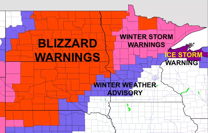
Blizzard conditions into Wednesday night for NW Minnesota
Go Deeper.
Create an account or log in to save stories.
Like this?
Thanks for liking this story! We have added it to a list of your favorite stories.


Updated 9:30 a.m.
Snow showers will continue to fill in across central and northern Minnesota Tuesday morning, with rain in southern Minnesota. Wind gusts rise to 35-50 mph, with 60 mph possible along the North Shore. Freezing rain may fall from central Minnesota up through the North Shore.
Rain, snow, ice Tuesday into Wednesday
Precipitation will continue to fill in Tuesday morning across Minnesota with snow expanding in central and northern Minnesota and rain showers moving into southern Minnesota.

Freezing rain will develop Tuesday afternoon into Tuesday night in areas where temperatures fall below freezing,

There’s also the threat of some isolated severe weather in southeastern Minnesota. The main threat is that some thunderstorms that develop this evening could produce large hail:
Turn Up Your Support
MPR News helps you turn down the noise and build shared understanding. Turn up your support for this public resource and keep trusted journalism accessible to all.

Gusty winds will increase late Tuesday into Wednesday with some areas experiencing wind gusts greater than 50 mph.

Snow totals will be limited in central Minnesota where a wintry mix of freezing rain and sleet along with snow will reduce snowfall amounts. Northwestern Minnesota will see the most significant snowfall as it wraps up Wednesday night.

Colder, then warmer this weekend
Behind the storm system, it will be pretty chilly with temperatures averaging 10 to 25 degrees below normal Thursday. Highs Thursday will be mainly in the 20s and 30s but we will see sunshine break out from south to north.

Temperatures warm up Friday into the weekend with much milder readings by Saturday and Sunday. It looks increasingly likely we’ll see our first 60s for southern Minnesota that have not yet seen them.

Most of the models agree also, on bringing in the first 70-degree readings to southern Minnesota at some point next week. Here’s one such scenario from the European Centre for Medium-Range Weather Forecasts model for next Thursday, April 13:

So hang on Minnesota. We’ve got a messy storm but then some real spring weather coming!

