
Weekend weather: Breezy, warmer; Sunday afternoon shower chance
40s Saturday in NW Minnesota; lower 60s in far southeast
Go Deeper.
Create an account or log in to save stories.
Like this?
Thanks for liking this story! We have added it to a list of your favorite stories.


We’ve had a reluctant spring, but our patience will be rewarded this weekend.
I will get to the weekend weather forecast details after a quick update on Thursday’s wintry weather in parts of northeastern Minnesota and northwestern Wisconsin.
A winter weather advisory for periods of snow and reduced visibilities continues Thursday afternoon in the blue-shaded areas of northeastern Minnesota and northwestern Wisconsin:

Here are details of the advisory:
Turn Up Your Support
MPR News helps you turn down the noise and build shared understanding. Turn up your support for this public resource and keep trusted journalism accessible to all.
URGENT - WINTER WEATHER MESSAGE National Weather Service Duluth MN 953 AM CDT Thu Apr 6 2023 MNZ037-WIZ001>004-062300- /O.NEW.KDLH.WW.Y.0029.230406T1453Z-230406T2300Z/ Carlton and South St. Louis-Douglas-Bayfield-Ashland-Iron- Including the cities of Duluth, Superior, Washburn, Bayfield, Ashland, and Hurley 953 AM CDT Thu Apr 6 2023 ...WINTER WEATHER ADVISORY IN EFFECT UNTIL 6 PM CDT THIS EVENING... * WHAT...Heavy snow showers. Additional snow accumulations of up to two inches with locally higher amounts to 4 inches possible. Winds gusting as high as 35 mph. * WHERE...In Minnesota, Carlton and South St. Louis County. In Wisconsin, Douglas, Bayfield, Ashland and Iron Counties. This includes the Tribal Lands of the Red Cliff Band, the northwestern area of the Lac du Flambeau Band, the Fond du Lac Band and the Bad River Reservation. * WHEN...Until 6 PM CDT this evening. * IMPACTS...Plan on slippery road conditions. Patchy blowing snow could significantly reduce visibility. The hazardous conditions could impact the evening commute. Visibility will of 1/4 mile or less is expected in the heavy snow bands. * ADDITIONAL DETAILS...The greatest snow accumulation through this afternoon is forecast south of a line from Wright and Cromwell in Carlton County to Maple to Ashland to Saxon. An additional dusting to a half inch of accumulation is expected farther north over Cloquet, Duluth, Superior, and Washburn. Snow squalls are possible through this afternoon. PRECAUTIONARY/PREPAREDNESS ACTIONS... Slow down and use caution while traveling. The latest road conditions can be obtained by calling 5 1 1. Road conditions can also be found at 511mn.org for Minnesota or 511wi.gov for Wisconsin.
Gale warnings continue Thursday afternoon on Lake Superior.
Sunday shower chance
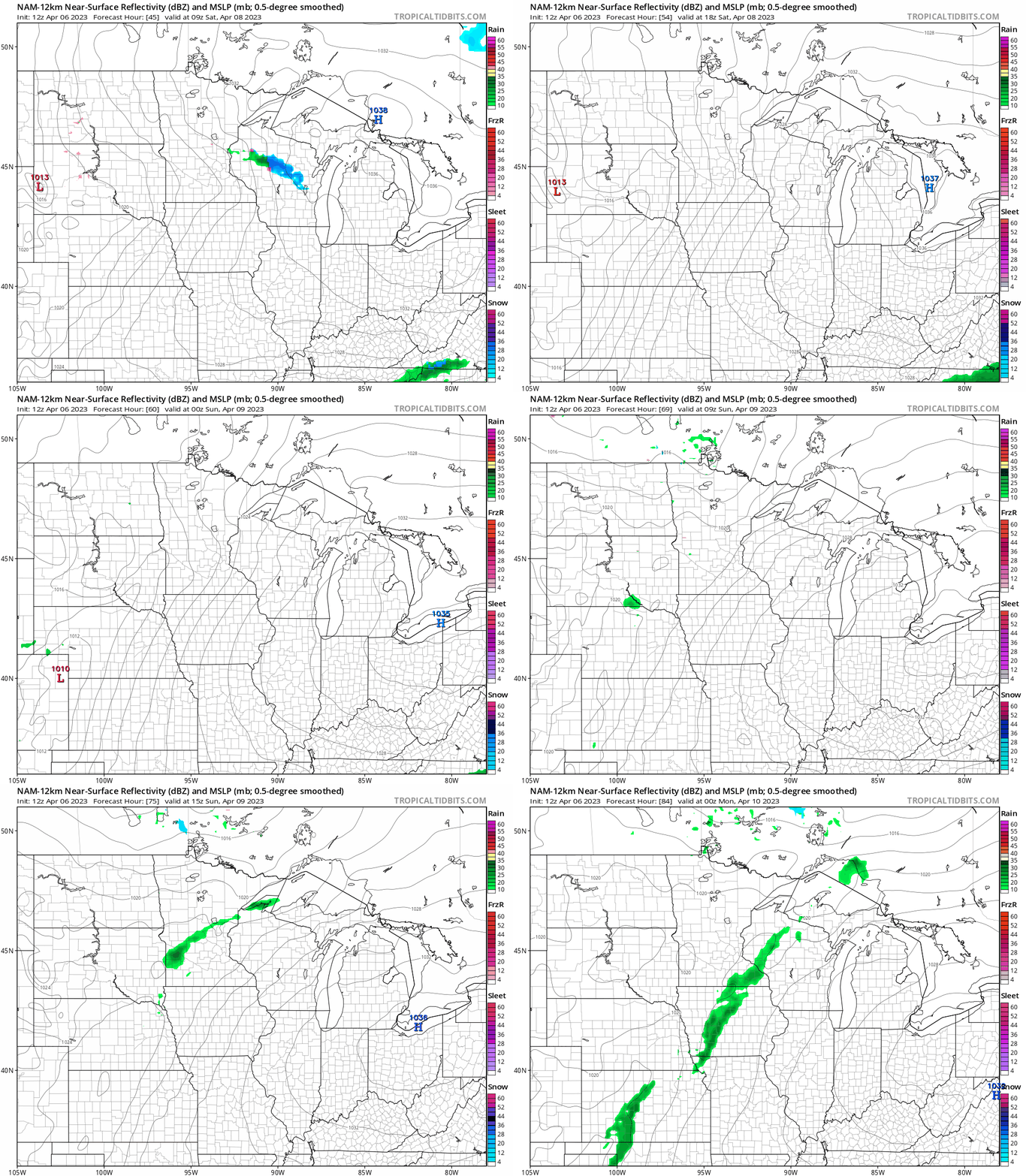
After a rain shower chance Friday night, dry weather is expected across most of Minnesota and western Wisconsin Saturday and through Saturday night.
Some rain showers could move into western Minnesota Sunday morning. Eastern Minnesota and western Wisconsin could see rain showers at times Sunday afternoon.
The National Oceanic and Atmospheric Administration’s North American Mesoscale (NAM) forecast model shows the potential precipitation pattern from 4 a.m. Saturday to 7 p.m. Sunday:
You can find updated weather information for Minnesota and western Wisconsin on the MPR News network.
Weekend temps and winds
The average Twin Cities high temperature on April 8 is 53 degrees. Twin Cities metro area highs are expected to be around 60 degrees Saturday. Saturday highs will range from mainly 40s in northwestern Minnesota to lower 60s in the far southeast:

A few spots in far northwestern Minnesota might only reach the upper 30s.
It’ll be a bit breezy on Saturday, with afternoon wind gusts over 22 mph in western Minnesota and around 17 to 20 mph in eastern Minnesota:

Forecast wind gusts are in knots, with 20 knots equal to 23 mph.
Sunday highs will range from 40s in northwestern Minnesota to 60s in the Twin Cities metro area and southeastern Minnesota:

Programming note
You can hear my live weather updates on MPR News at 7:35 a.m., 9:35 a.m. and 4:39 p.m. Saturday and Sunday.

