
Colder temps this weekend; Saturday rain, then a mix Sat. night to mainly snow on Sunday
Strongest winds on Sunday
Go Deeper.
Create an account or log in to save stories.
Like this?
Thanks for liking this story! We have added it to a list of your favorite stories.


Many of us are waking up to rain this Saturday. Periods of rain are expected across most of Minnesota and western Wisconsin, with some embedded thunderstorms at times.
High temperatures happened earlier this morning in many areas, with highs the remainder of Saturday ranging form 30s in northwestern and west-central Minnesota to 50s and lower 60s in the far southeast:

Rain to snow
The Saturday rain may be mixed with snowflakes in parts of western Minnesota. Cooler air will spread that rain/snow mix eastward Saturday evening and overnight Saturday night. On Sunday, most of eastern Minnesota and much of Wisconsin will see mainly snow, with a mix possible at times.
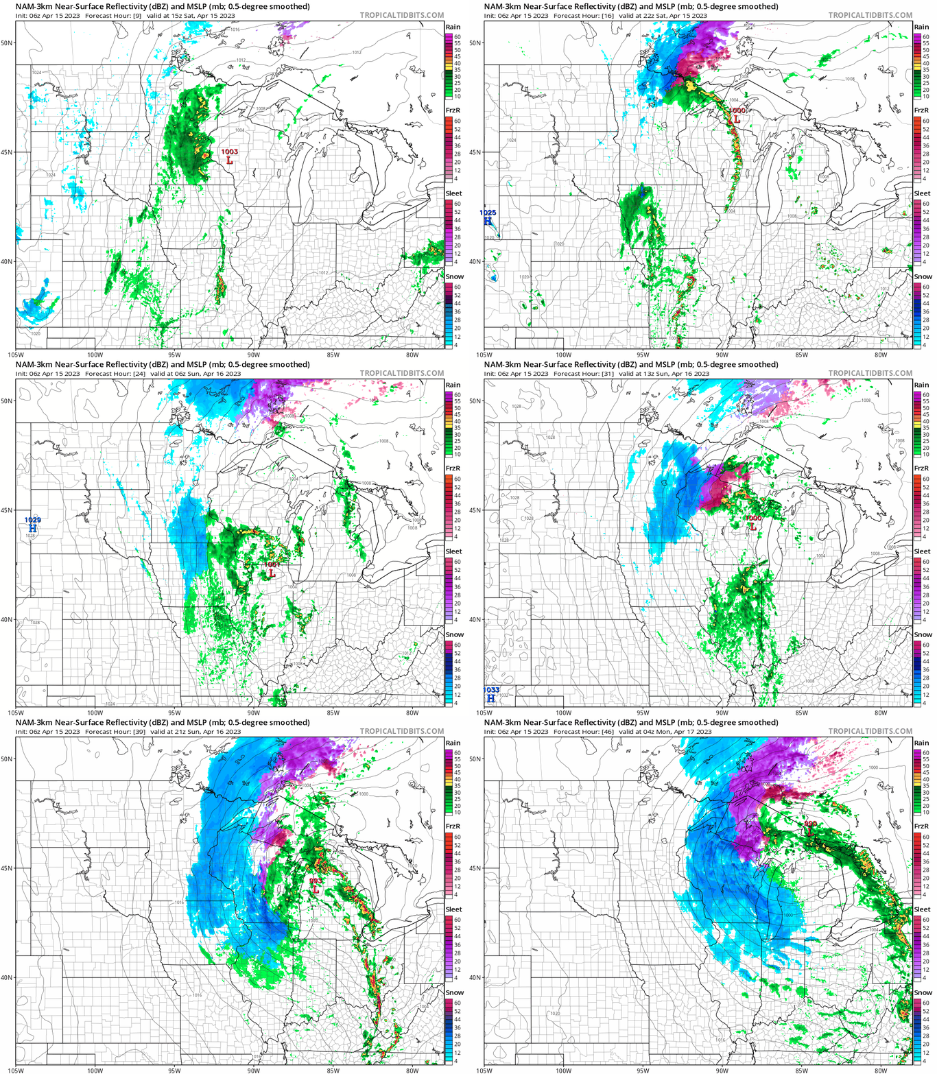
The National Oceanic and Atmospheric Administration’s North American Mesoscale (NAM) forecast model shows the potential precipitation pattern from 10 a.m. Saturday to 11 p.m. Sunday:
Turn Up Your Support
MPR News helps you turn down the noise and build shared understanding. Turn up your support for this public resource and keep trusted journalism accessible to all.
How much snow?
The snow will melt on some surfaces initially, and winds will be strong on Sunday. The heaviest snow totals are expected in Wisconsin:

Twin Cities metro area totals of 2 to 4 inches are possible Sunday through Sunday evening. Parts of southeastern Minnesota could see 5 or 6 inches of snow from Sunday into Monday morning.
A winter storm watch starts at 7 p.m. Sunday and continues to 10 a.m. Monday from Barron County, Wisconsin south to Winona County and Houston County of Minnesota and then eastward:
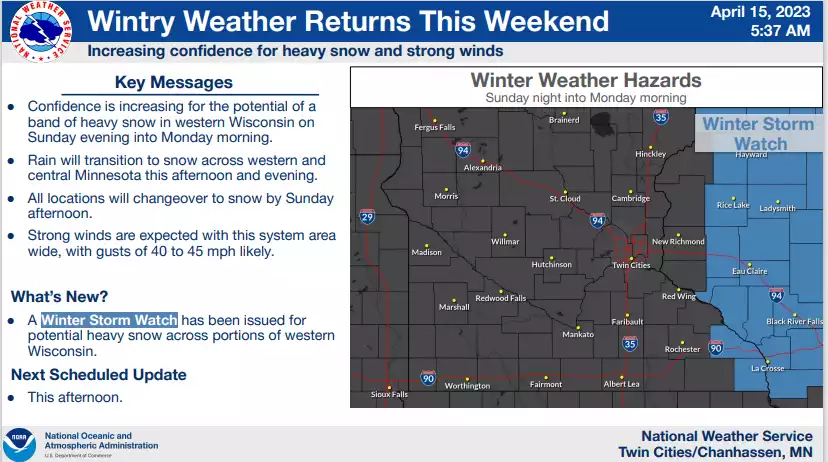
Here are watch details for western Wisconsin:
URGENT - WINTER WEATHER MESSAGE National Weather Service Twin Cities/Chanhassen MN 251 AM CDT Sat Apr 15 2023 WIZ015-016-025>028-151600- /O.NEW.KMPX.WS.A.0011.230417T0000Z-230417T1500Z/ Barron-Rusk-Dunn-Pepin-Chippewa-Eau Claire- Including the cities of Rice Lake, Ladysmith, Menomonie, Durand, Chippewa Falls, and Eau Claire 251 AM CDT Sat Apr 15 2023 ...WINTER STORM WATCH IN EFFECT FROM SUNDAY EVENING THROUGH MONDAY MORNING... * WHAT...Heavy snow possible. Total snow accumulations of 4 to 8 inches possible. Winds could gust as high as 45 mph. * WHERE...Portions of northwest and west central Wisconsin. * WHEN...From Sunday evening through Monday morning. * IMPACTS...Plan on slippery road conditions. The hazardous conditions could impact the morning commute. PRECAUTIONARY/PREPAREDNESS ACTIONS... Monitor the latest forecasts for updates on this situation.
A winter storm watch starts at 1 a.m. Sunday and runs to 7 p.m. Monday in Lake County and Cook County of northeastern Minnesota:

A winter storm watch begins at 4 p.m. Sunday and runs to 10 a.m. Monday in Douglas County and Washburn County of northwestern Wisconsin.
Here are potential snow amounts:

Programming note
You can hear my live weather updates on MPR News at 7:35 a.m., 9:35 a.m. and 4:39 p.m. each Saturday and Sunday.

