
Windy Sunday, with rain at times and some flakes too; Warmer by midweek
Snow will pile up in northern Wisconsin
Go Deeper.
Create an account or log in to save stories.
Like this?
Thanks for liking this story! We have added it to a list of your favorite stories.


Where is the warmth this weekend? Not in Minnesota or western Wisconsin.
The Saturday high temp at Minneapolis-St. Paul International was 55 degrees. That’s 8 degrees shy of the Twin Cities average April 29 high temperature.
Some locations in Minnesota and western Wisconsin never made it out of the 40s.
Temperature trends
Sunday highs will be in the 50s in western Minnesota, with mainly 40s in eastern Minnesota and western Wisconsin:
Turn Up Your Support
MPR News helps you turn down the noise and build shared understanding. Turn up your support for this public resource and keep trusted journalism accessible to all.

Sunday will be windy, with gusts over 40 mph possible.
Monday highs will be mainly in the 50s, with some 40s in northeastern Minnesota and northwestern Wisconsin:

Warmer temps will follow. Twin Cities metro area highs are projected to be around 60 degrees on Tuesday, followed by upper 60s to around 70 degrees Wednesday and Thursday and then lower 60s on Friday. Temperatures may be near normal next weekend, then we could see some warmer temps.
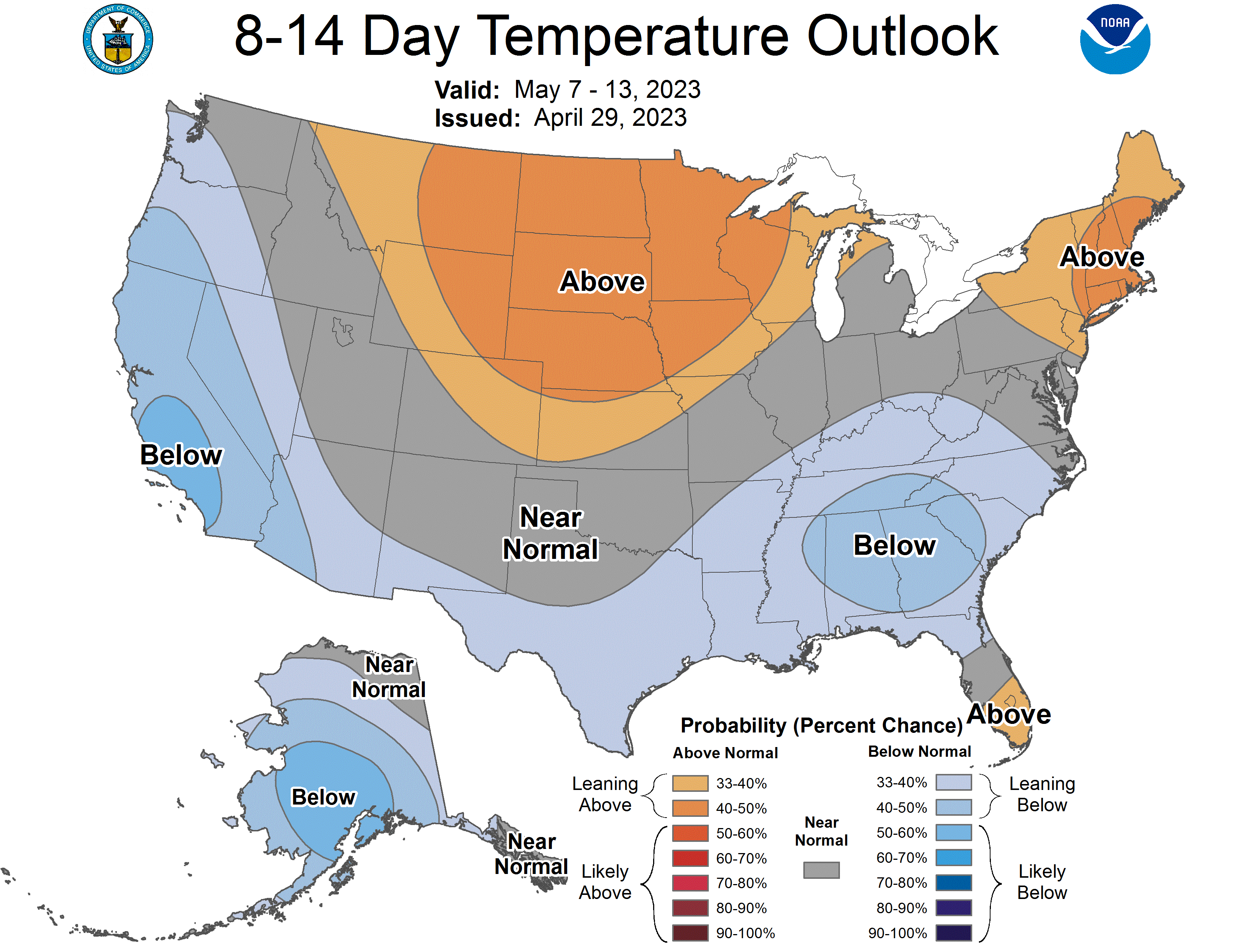
The May 7 through May 13 temperature outlook from the NWS Climate Prediction Center shows a tendency for above-normal temps in Minnesota and western Wisconsin::
Rain and snow chances
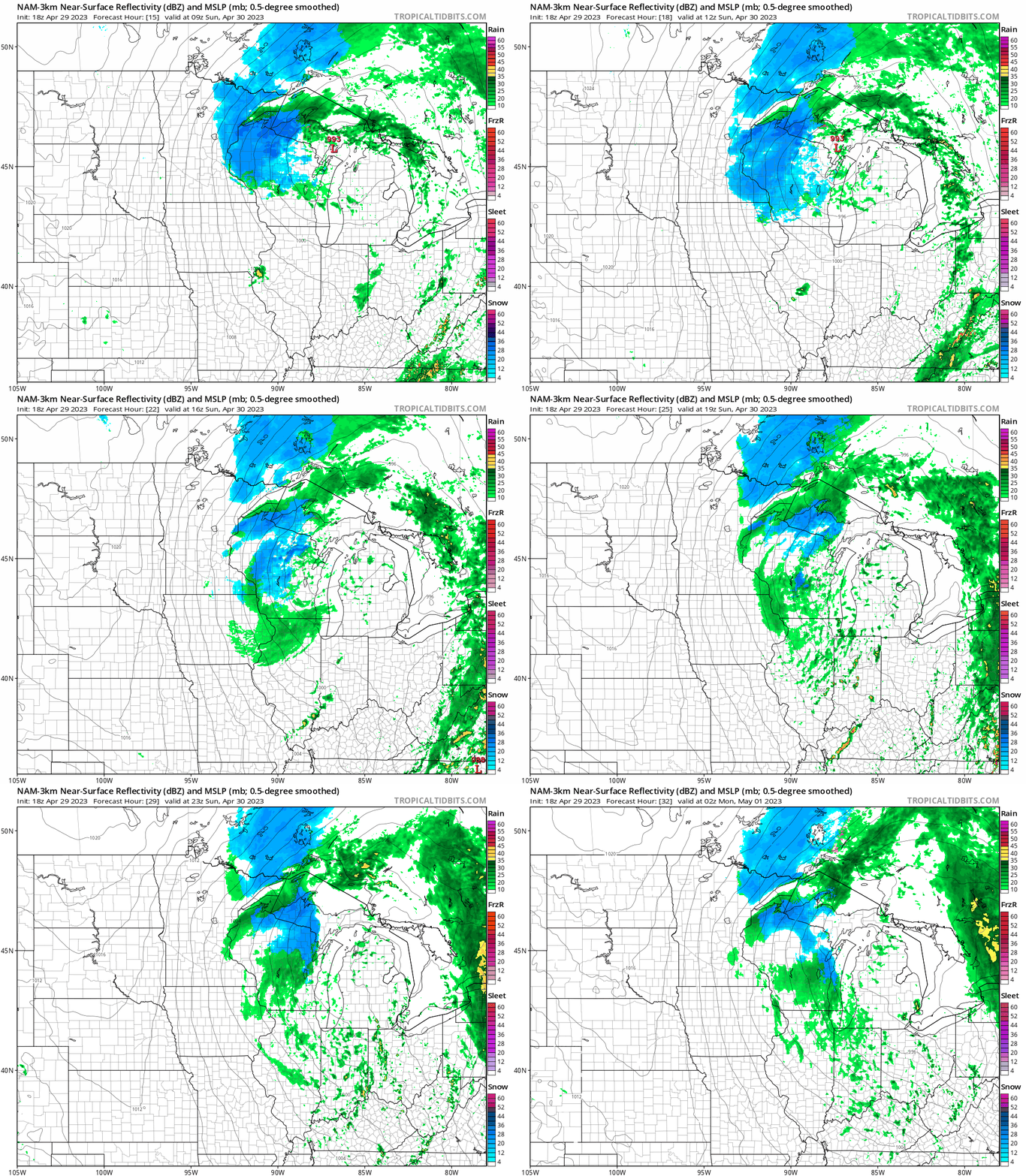
Scattered showers will continue in Minnesota and western Wisconsin into Saturday evening. Then a more substantial batch of moisture will spread over eastern Minnesota and Wisconsin overnight Saturday night and linger through Sunday.
Northeastern Minnesota and northern Wisconsin may see mainly snow overnight and Sunday morning, then the snow changes to a rain/snow mix in northeastern Minnesota while snow continues in northern Wisconsin.
The Twin Cities metro area, southeastern Minnesota and west-central Wisconsin could see a rain/snow mix late Saturday night and early Sunday, followed by periods of mainly rain Sunday afternoon.
The National Oceanic and Atmospheric Administration’s North American Mesoscale (NAM) forecast model shows the potential precipitation pattern from 4 a.m. Sunday to 9 p.m. Sunday:
Potential snow totals
Parts of the Twin Cities metro area and west-central Wisconsin could see light snow accumulations on grassy areas late Saturday night and early Sunday, but any light snow accumulations would tend to melt by afternoon.
Northeastern Minnesota could see some 1 to 3 inch snow totals Saturday night through Sunday morning, with higher snow amounts in northern Wisconsin:

The snow continues Sunday afternoon and into Monday in parts of northern Wisconsin:

Some spots in north-central Wisconsin will see more than one foot of snow over the next couple of days.
A winter storm warning covers Ashland and Iron counties of north-central Wisconsin from Saturday evening through Monday morning. A winter weather advisory covers Douglas and Bayfield counties of northwestern Wisconsin Saturday night through Sunday morning:

Here are advisory details:
URGENT - WINTER WEATHER MESSAGE National Weather Service Duluth MN 253 PM CDT Sat Apr 29 2023 WIZ001-002-009-300900- /O.NEW.KDLH.WW.Y.0035.230430T0300Z-230430T1800Z/ Douglas-Bayfield-Price- Including the cities of Superior, Washburn, Bayfield, and Phillips 253 PM CDT Sat Apr 29 2023 ...WINTER WEATHER ADVISORY IN EFFECT FROM 10 PM THIS EVENING TO 1 PM CDT SUNDAY... * WHAT...Wet snow expected. Localized total snow accumulations of 3 to 5 inches. Winds gusting as high as 35 mph. * WHERE...Douglas, Bayfield and Price Counties. This includes the Tribal Lands of the Red Cliff Band. * WHEN...From 10 PM this evening to 1 PM CDT Sunday. * IMPACTS...Plan on slippery road conditions. * ADDITIONAL DETAILS...The heaviest snow is not expected to impact the city of Superior in Douglas County. PRECAUTIONARY/PREPAREDNESS ACTIONS... Slow down and use caution while traveling. The latest road conditions can be obtained by calling 5 1 1. Road conditions can also be found at 511wi.gov for Wisconsin.
A wind advisory covers parts of northeastern Minnesota on Sunday and Monday.
You can find updated weather information for Minnesota and western Wisconsin on the MPR News network.
The NWS Duluth office and NWS Twin Cities office will have forecast updates overnight and on Sunday.
Programming note
You can hear my live weather updates on MPR News at 7:35 a.m., 9:35 a.m. and 4:39 p.m. each Saturday and Sunday.

