
Rain at times Saturday, t-storms in some areas; Flood watch much of southern Minn.
Driest far northern Minnesota
Go Deeper.
Create an account or log in to save stories.
Like this?
Thanks for liking this story! We have added it to a list of your favorite stories.


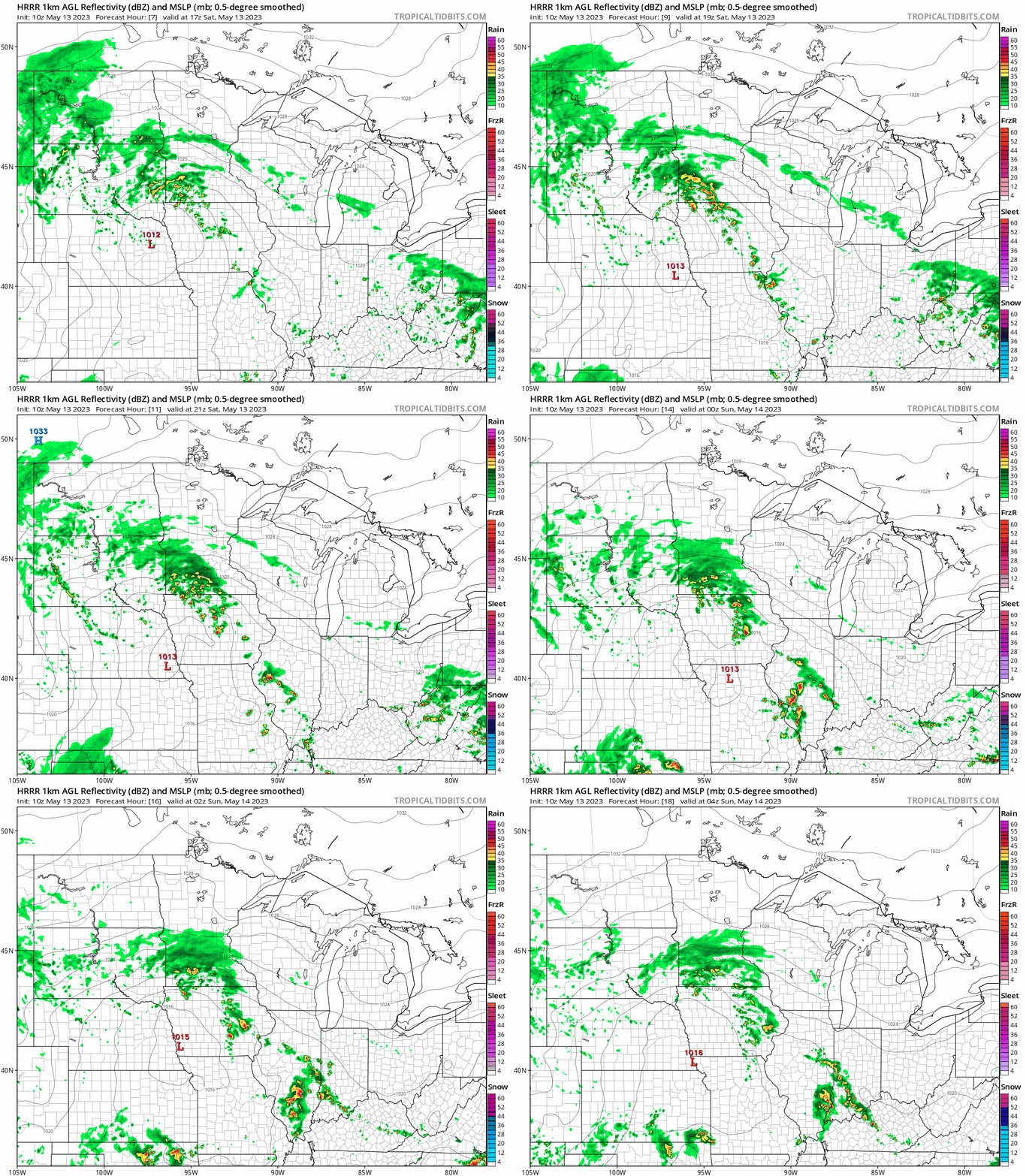
Much of west-central, southwestern and south-central Minnesota have rain this Saturday morning, with some embedded thunderstorms. Those same areas will see the steadiest and heaviest rain today and tonight.
Intermittent showers and a few embedded t-storms are possible elsewhere in the southern two-thirds of Minnesota plus western Wisconsin today and tonight.
The National Oceanic and Atmospheric Administration’s High-Resolution Rapid-Refresh model shows the potential rain pattern from noon Saturday to 11 p.m. Saturday:
The ground is already soggy in parts of southern Minnesota and additional significant rain could cause areas of flash flooding. A flood watch continues Saturday and through Saturday night for the counties that are shaded green:
Turn Up Your Support
MPR News helps you turn down the noise and build shared understanding. Turn up your support for this public resource and keep trusted journalism accessible to all.

Here are details of the flood watch:
Flood Watch National Weather Service Twin Cities/Chanhassen MN 301 AM CDT Sat May 13 2023 .Rounds of heavy rain are expected this morning and again later this afternoon and tonight across southern Minnesota. Widespread totals of 2 to 3 inches are expected with localized areas over 5 inches possible. This is the same region that received 2 to 4 inches Wednesday night into Thursday morning. The recent heavy rain, and the snow melt from a few weeks ago, have left soils saturated and susceptible to flooding with any additional heavy rainfall. MNZ064-073-074-082-132015- /O.EXT.KMPX.FA.A.0001.230513T0801Z-230514T1200Z/ /00000.0.ER.000000T0000Z.000000T0000Z.000000T0000Z.OO/ Yellow Medicine-Redwood-Brown-Watonwan- Including the cities of New Ulm, Redwood Falls, St James, and Granite Falls 301 AM CDT Sat May 13 2023 ...FLOOD WATCH NOW IN EFFECT THROUGH SUNDAY MORNING... * WHAT...Flash flooding caused by excessive rainfall continues to be possible. * WHERE...Portions of south central Minnesota, southwest Minnesota and west central Minnesota, including the following counties, in south central Minnesota, Brown and Watonwan. In southwest Minnesota, Redwood. In west central Minnesota, Yellow Medicine. * WHEN...Through Sunday morning. * IMPACTS...Excessive runoff may result in flooding of rivers, creeks, streams, and other low-lying and flood-prone locations. Creeks and streams may rise out of their banks. * ADDITIONAL DETAILS... - Rounds of heavy rainfall could produce totals of 2 to 3 inches, with isolated locations receiving in excess of 5 inches. This will lead to the possibility of flash flooding. PRECAUTIONARY/PREPAREDNESS ACTIONS... You should monitor later forecasts and be prepare
You can find updated weather information for Minnesota and western Wisconsin on the MPR News network. You can also check the following National Weather Service sites for updated weather info: Twin Cities, Duluth, La Crosse, Wis., Sioux Falls, S.D., Grand Forks, N.D.
Temperatures
The average Twin Cities high temperature is 68 degrees on May 13. Twin Cities metro area highs are forecast to be slightly above 70 on Saturday. Northern Minnesota will see a lot of 70s Saturday afternoon, with mainly 60s to the south and also in northwestern Wisconsin:

Portions of southeastern Minnesota and west-central Wisconsin will reach the lower 70s. There will be some 50s near Lake Superior.
It’ll be breezy today, with gusts of 25 to 30 mph possible. Higher gusts can be expected near any thunderstorms that develop.
Update
A new Updraft will be posted around 10:20 a.m. and will include a look at Sunday and the week ahead.
Programming note
You can hear my live weather updates on MPR News at 7:35 a.m., 9:35 a.m. and 4:39 p.m. each Saturday and Sunday.

