Mild night; showers west into Memorial Day
Most of Minnesota remains dry until Tuesday
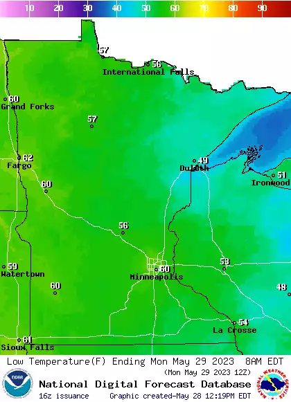
Temperatures will dip into the 50s to near 60 overnight with some 40s in northeast Minnesota. A few showers are possible late Sunday night in far northwest Minnesota. Memorial Day will bring spotty thunder chances again to west central and northwest Minnesota.
Dry, warm for most Memorial Day
It’ll be a mild overnight Sunday night, in the 50s to around 60 with pockets of upper 40s in northeast Minnesota and along the North Shore. We’ll see a few possible showers or a thunderstorm in far northwest Minnesota late Sunday night into early Monday.
The chance of some spotty thunder will again be possible in west central and northwest Minnesota Memorial Day afternoon and evening.
High temperatures Monday will be well into the 80s for most of Minnesota.
Create a More Connected Minnesota
MPR News is your trusted resource for the news you need. With your support, MPR News brings accessible, courageous journalism and authentic conversation to everyone - free of paywalls and barriers. Your gift makes a difference.
Air quality alert Sunday into Monday
We have an air quality alert in effect through 8 p.m. Monday.
The concern is for elevated ozone levels especially in the afternoon and evening hours Sunday and Monday. Check the latest air quality conditions and forecasts here:
Here are air quality forecasts for the next couple of days also:
Chance of some thunder midweek
The chance of at least some isolated and spotty thunderstorms spreads east Tuesday into Wednesday and even Thursday as our upper level ridge moves east ushering in an unsettled pattern.
It will also start to get fairly steamy as dew points increase into the 60s by Tuesday and Wednesday.
Temperatures will get close to 90 for portions of southern and western Minnesota Wednesday and Thursday as well.