
Weekend forecast: Thunderstorm chances on Saturday, shower chance on Sunday
Warmest temps on Saturday
Go Deeper.
Create an account or log in to save stories.
Like this?
Thanks for liking this story! We have added it to a list of your favorite stories.


We really need some rain, with 39% of Minnesota currently in drought (beige and orange- shaded areas) according to U.S. Drought Monitor:
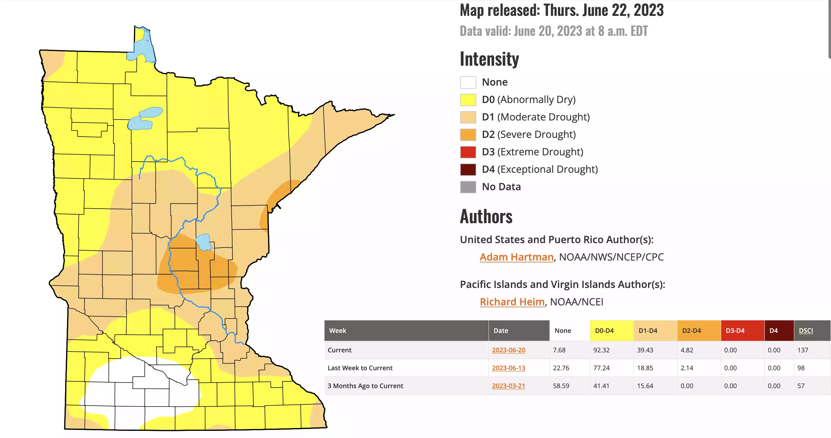
About 53% of Minnesota (yellow) is abnormally dry, but not yet in drought. Only 8% of Minnesota is not either abnormally dry or in drought.
The Twin Cities metro area is currently in moderate drought, according to U.S. Drought Monitor. Minneapolis-St. Paul International Airport has tallied just one-tenth of an inch of rain this June. That is about three inches below normal for this point in the month, and May rainfall was more than two inches below normal.
Parts of the east metro area did receive between one and two inches of rain on Saturday, June 10, but those locations are still more than one inch below normal for this point in June.
Turn Up Your Support
MPR News helps you turn down the noise and build shared understanding. Turn up your support for this public resource and keep trusted journalism accessible to all.
Weekend rain chances
An approaching cold front plus the heating of the day will combine to generate some showers and thunderstorms Saturday and Saturday evening. Some thunderstorms could linger overnight Saturday night. A few patchy showers will be possible on Sunday.
NOAA’s North American Mesoscale forecast model shows the potential rain pattern from 4 a.m. Saturday to 7 p.m. Saturday:
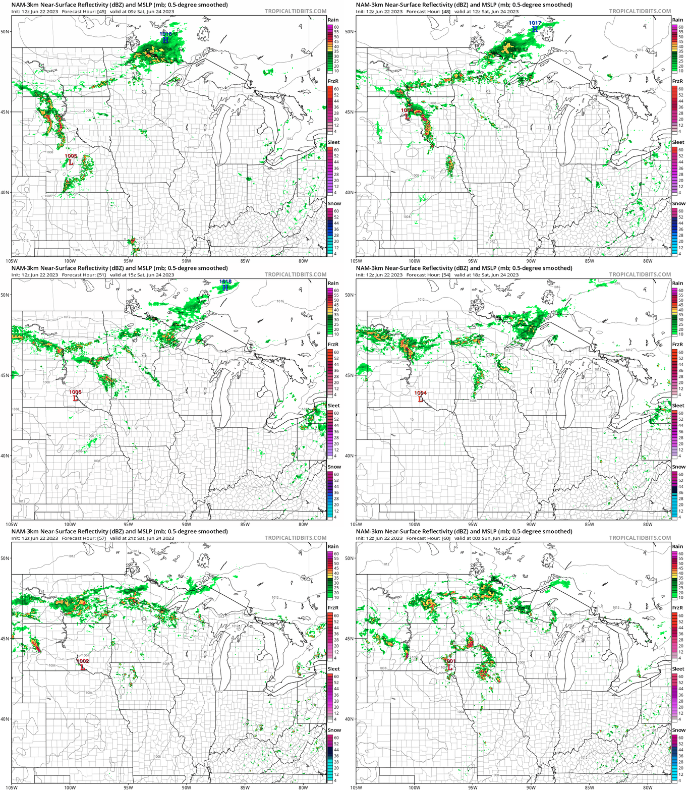
The actual rain coverage may be more substantial than what is depicted on the model, so check forecast updates.
You can find updated weather information for Minnesota and western Wisconsin on the MPR News network.
Saturday severe weather potential
The NWS Storm Prediction Center shows a slight risk (yellow) of severe weather in southwestern and south-central Minnesota Saturday and Saturday night, with a marginal risk (darker green) in other areas, including the Twin Cities:

Slight risk means that scattered severe thunderstorms are possible and marginal risk means that an isolated severe thunderstorm is possible:

The Storm Prediction Center will update the severe weather outlook over the next few days. Be weather-aware this weekend and make sure that you have a way to receive any weather warnings that are issued.
Weekend temps
The average Twin Cities high temperature is 81 degrees on June 24. Parts of the metro area will see Saturday highs in the mid 80s.
Most of central and southern Minnesota and western Wisconsin will have Saturday highs in the 80s, with 70s in much of northern Minnesota:

There will be some 60s near Lake Superior.
Saturday afternoon dew points will be in the sticky 60s in many areas:

Sunday highs will be mainly in the 70s, with 60s in northeastern Minnesota:

Programming note
You can hear my live weather updates on MPR News at 7:35 a.m., 9:35 a.m. and 4:39 p.m. each Saturday and Sunday.

