
Scattered thunderstorms possible Saturday night; Cooler Sunday, with scattered showers
Update on Saturday tornado reports
Go Deeper.
Create an account or log in to save stories.
Like this?
Thanks for liking this story! We have added it to a list of your favorite stories.


Parts of Minnesota and western Wisconsin saw some much-needed rain Saturday afternoon and evening.
There was also some spotty severe weather, including several tornado reports in northwestern Minnesota:

Times listed are in Universal Time, which is five hours ahead of Central Daylight Time. For instance, a time stamp of 2105 is 4:05 p.m. CDT.
There can be multiple reports of the same tornado. Here’s a pic of the Saturday afternoon tornado in Norman County of northwestern Minnesota:
Turn Up Your Support
MPR News helps you turn down the noise and build shared understanding. Turn up your support for this public resource and keep trusted journalism accessible to all.
The tornado watch in portions of northwestern Minnesota has been extended to 9 p.m. this Saturday evening.
Saturday night rain chances
Additional areas of showers and thunderstorms are expected Saturday night, and a few spots could see a strong or severe thunderstorm. Some spots in northwestern and north-central Minnesota could see locally heavy rainfall Saturday night.
You can hear updated weather information for Minnesota and western Wisconsin on the MPR News network. You can find the latest radar here.
You can also check these National Weather Service sites for updated weather info: Twin Cities, Duluth, La Crosse, Wis., Sioux Falls, S.D., Grand Forks, N.D.
Sunday rain chances
A low pressure system will shift eastward on Sunday, with the best thunderstorm chances shifting into Wisconsin. Some wrap-around showers and a few very spotty t-storms will still be possible in Minnesota on Sunday.
The National Oceanic and Atmospheric Administration’s North American Mesoscale forecast model shows the potential rain pattern from 6 a.m. Sunday to 10 p.m. Sunday:

NOAA’s High-Resolution Rapid Refresh (HRRR) model shows a similar rain pattern for Sunday:
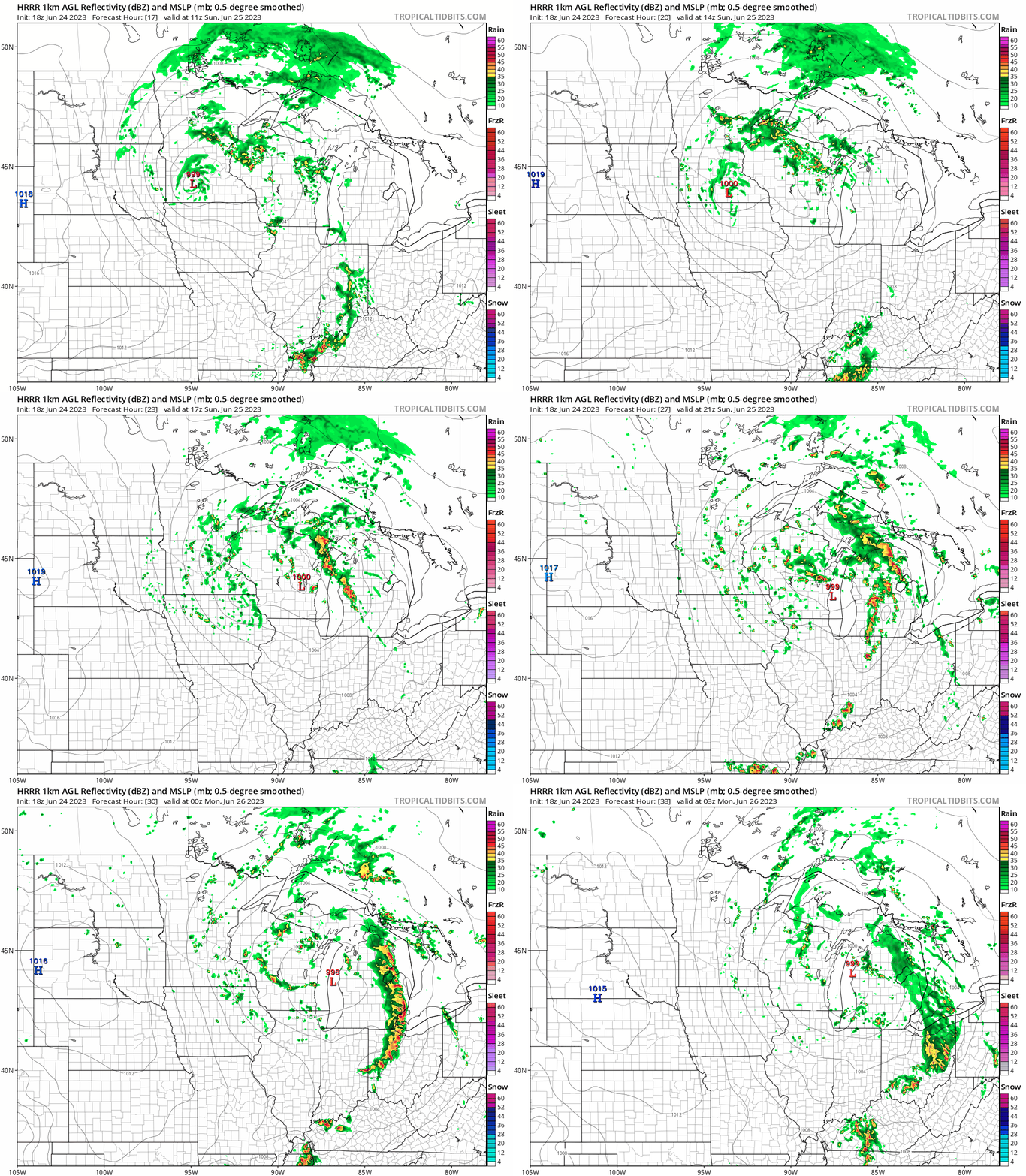
Check forecast updates.
A stray shower will be possible on Monday, but most locations won’t see any rain.
Air quality alert up north
The Minnesota Pollution Control Agency has issued an air quality alert for northern Minnesota that will continue until 9 a.m. Monday:

Here are details of the alert, from MPCA:
Air quality alert expanded due to wildfire smoke for northern Minn. through Monday, June 26 at 9 a.m.
Air quality is expected to reach orange in northern Minn., which is unhealthy for sensitive groups.
The Minnesota Pollution Control Agency (MPCA) has issued an air quality alert for northern Minn. for fine particulate, effective Saturday, June 24, through Monday, June 26, at 9 a.m. The affected area in northern Minn. includes Bemidji, East Grand Forks, International Falls, Two Harbors, Hibbing, Ely, Duluth, Roseau, and the tribal nations of Red Lake, Leech Lake, Grand Portage, and Fond du Lac.
Northerly winds are bringing smoke from wildfires north of the Canadian border in Ontario into northern Minn. This batch of smoke will be heavier and more persistent closer to the Canadian border, while the southern portion of the alert area may see occasional smoke. Smoke will continue over northern Minn. through early Monday. People should keep windows shut to prevent smoke from entering. Smoke will circulate around the northern periphery of a low-pressure area heading eastward through Minn. Some smoke may linger on Monday, but concentrations should fall below orange.
Fine particle levels are expected to be in the orange AQI category, a level that is considered unhealthy for sensitive groups. In the orange area, sensitive groups should avoid prolonged time outdoors.
Temperature trends
The Saturday high temperature at Minneapolis-St. Paul International Airport was 84 degrees. That’s three degrees warmer than the average June 24 Twin Cities high temperature.
Metro area highs are expected to be much cooler on Sunday, topping out in the lower 70s. Much of northern Minnesota will have Sunday highs in the 60s, with a few 70s in the far northwest:

Twin Cities metro area highs are projected to reach the upper 70s on Monday, followed by lower 80s Tuesday, Wednesday and Thursday then around 80 on Friday.
Programming note
You can hear my live weather updates on MPR News at 7:35 a.m., 9:35 a.m. and 4:39 p.m. each Saturday and Sunday.

