Coolest night since May Tuesday night; frost advisory northeast
Sunshine is back Wednesday and warmer temps Thursday
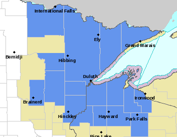
A few lingering showers and clouds will be with us Tuesday as chilly air continues to settle in. Overnight Tuesday night will be the coolest since May for many places.
Coolest night in nearly four months Tuesday night
We’ll have lingering showers Tuesday, especially in northeast Minnesota and western Wisconsin.

There have been decent pockets of rainfall over the past 24 hours — mainly on the Iron Range and a few lucky swaths of the west metro late Monday night. Notably the area between Hibbing, Virginia and Cotton saw 1 to 3 inches of rainfall.

The Duluth area saw a torrential downpour that dropped 3 to 6 inches of rain in just a 4-square-mile area causing flooding.
Grow the Future of Public Media
MPR News is supported by Members. Gifts from individuals power everything you find here. Make a gift of any amount today to become a Member!

Highs Tuesday will be in just the 50s north to 60s south. A few spots in southwest Minnesota will squeeze out a 70 degree high.

Skies will clear this evening, setting us up for a chilly night. In fact, it will be the coolest night since May for most.

There’s a frost advisory for much of northeast Minnesota and northwest Wisconsin for late Tuesday night into early Wednesday morning.

Summer temperatures return
Sunny skies are back for Wednesday and temperatures will be slightly warmer as a result, but still below normal.

Thursday will bring a return to summer warmth with above normal temperatures again. Many areas in southern Minnesota will be near 80 degrees.

The next upper level disturbance will increase cloud cover Friday and bring another chance of spotty showers. Unfortunately, once again, it will not be a widespread soaking but rather localized rainfall.