Fall heat wave continues; weekend storm system to bring rain
Air quality alert in NW Minnesota through 11 p.m. Thursday
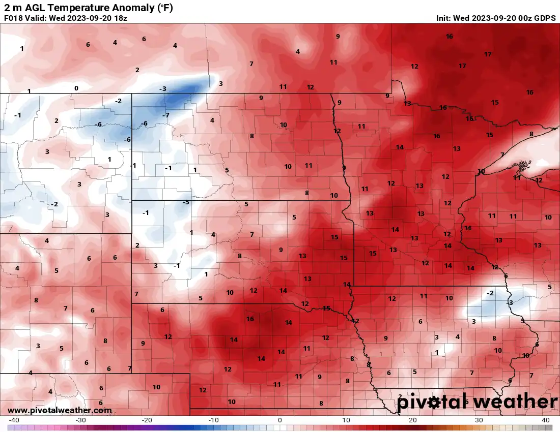
![T anom WED](https://img.apmcdn.org/6d2d2c3d91829c6f9ace8940117b9f660867f7cb/uncropped/c18ff8-20230920-t-anom-wed-1100.png)
Like this?
Log in to share your opinion with MPR News and add it to your profile.
Like this?
Thanks for liking this story! We have added it to a list of your favorite stories.
It’s going to be another July-like day Wednesday with highs well into the 80s across southern Minnesota. Rain and cooler temperatures are on the way for the weekend.
Fall heat wave continues Wednesday, Thursday
Several spots hit 90 degrees Tuesday afternoon in west-central Minnesota. Madison, Minn., reached a high of 95 degrees. While it was not a record for the date, it appears to be the latest 95-degree reading since 1984.
![highs YEST](https://img.apmcdn.org/33a7c1d257ddcfe8376aabc2dbcb7dc3b5e399b6/uncropped/b92710-20230920-highs-yest-1596.png)
Highs Wednesday will be well into the 80s again across southern Minnesota with 70s north.
![wed hi 9a](https://img.apmcdn.org/bd3e67e751b3956b10ac67fe087ab7c99c82d29d/uncropped/7ffc6b-20230920-wed-hi-9a-515.png)
An air quality alert remains in place through 11 p.m. Thursday for northwestern Minnesota where air quality is expected to reach the “orange” category: unhealthy for sensitive groups.
Support the News you Need
Gifts from individuals keep MPR News accessible to all - free of paywalls and barriers.
Check the latest air quality conditions, alerts and forecasts from the Minnesota Pollution Control Agency:
Thursday will likely pull off another 80 degree reading for most of southern Minnesota.
![thu hi 9a](https://img.apmcdn.org/180c7b6b2c0aa2df04a41fcdf91eda9e7fa6414f/uncropped/6c2527-20230920-thu-hi-9a-515.png)
There will be the chance of a stray shower or thunderstorm in the northern and western portions of Minnesota, well ahead of the main weekend storm system.
![thu precip](https://img.apmcdn.org/fe489ace9d8ed3ff4d64b6de1db5b87180b77e8b/uncropped/c081be-20230920-thu-precip-660.gif)
Weekend rains
A slowly moving upper-level low will bring a prolonged period of clouds and occasional rain showers starting early Saturday through Monday.
![weekend precip 9a](https://img.apmcdn.org/cba9497f42406c8a759f6d81ac8dacb59d6a8df5/uncropped/791cf5-20230920-weekend-precip-9a-660.gif)
As we’re getting closer to the weekend event and the storm is now in the western United States, we’re getting a better idea of where and how things will set up. There’s still a range of possibilities for rainfall but the heaviest rainfall looks to favor areas to the west with lighter amounts in northeastern Minnesota.
![WPC 168](https://img.apmcdn.org/28f407e8364949dd2269bca331142769f2e3f28a/uncropped/f2f3d2-20230920-wpc-168-1100.png)