
Windy with record warmth Sunday; cooler to start the week
No cold weather in sight
Go Deeper.
Create an account or log in to save stories.
Like this?
Thanks for liking this story! We have added it to a list of your favorite stories.


The earliest 70 degree reading in Twin Cities weather records is March 5, 2000. That record is expected to fall today.
Highs in the lower 70s are expected today in the Twin Cities metro area plus much of south-central and southeastern Minnesota and west-central Wisconsin. Highs in the 60s will stretch from southwestern Minnesota into central Minnesota, with 50s and 40s in most of northern Minnesota. Parts of far northwestern Minnesota will stay in the 30s.
Here are some March 3 record highs that are likely to be broken today:
Twin Cities: 65 (1905)
Turn Up Your Support
MPR News helps you turn down the noise and build shared understanding. Turn up your support for this public resource and keep trusted journalism accessible to all.
St. Cloud: 61 (1905)
Rochester: 56 (1946)
Eau Claire, Wisc.: 58 (1894)
The average Twin Cities high temperature is just 35 degrees this time of year.
Sunday wind gusts will be in the 30 mph to 40+ mph range in many areas.
You can hear updated weather information for Minnesota and western Wisconsin on the MPR News network.
Precipitation chances
The northern third of Minnesota plus portions of western Wisconsin will have the best chance to see some periods of rain Sunday afternoon and early Sunday evening. A few flakes are also possible in far northwestern Minnesota. An isolated thunderstorm is possible in Wisconsin late Sunday afternoon and Sunday evening.
Central and southern Minnesota could see a few scattered showers at times Sunday afternoon. The shower chance in the Twin Cities metro area will be mainly late Sunday afternoon.
Red flag warning and wind advisory Sunday afternoon
A red flag warning and a wind advisory cover portions of southern Minnesota Sunday afternoon:

Here are details of the red flag warning:
URGENT - FIRE WEATHER MESSAGE National Weather Service Twin Cities/Chanhassen MN 915 AM CST Sun Mar 3 2024 ...RED FLAG WARNING THIS AFTERNOON AND EVENING FOR SOUTHERN MINNESOTA... .Winds today will be out of the south at 25 to 30 mph with gusts to 45 mph. These winds combined with relative humidity values as low as 20 to 25 percent will result in critical fire weather conditions this afternoon. Any fires that form will have the potential to spread quickly. MNZ082>085-091>093-032315- /O.NEW.KMPX.FW.W.0001.240303T1800Z-240304T0000Z/ Watonwan-Blue Earth-Waseca-Steele-Martin-Faribault-Freeborn- 915 AM CST Sun Mar 3 2024 ...RED FLAG WARNING IN EFFECT UNTIL 6 PM CST THIS EVENING FOR GUSTY WINDS AND LOW RELATIVE HUMIDITY... The National Weather Service in Twin Cities/Chanhassen has issued a Red Flag Warning, which is in effect until 6 PM CST this evening. * WIND...South 25 to 30 mph with gusts to 45 mph. * HUMIDITY...20 to 25 percent, * IMPACTS...Any fires that develop will likely spread rapidly. Outdoor burning is not recommended. PRECAUTIONARY/PREPAREDNESS ACTIONS... A Red Flag Warning means that critical fire weather conditions are either occurring now, or will shortly. A combination of strong winds, low relative humidity, and warm temperatures can contribute to extreme fire behavior.
Here are details of the wind advisory in southern Minnesota:
URGENT - WEATHER MESSAGE National Weather Service Twin Cities/Chanhassen MN 835 AM CST Sun Mar 3 2024 MNZ082>085-091>093-040000- /O.NEW.KMPX.WI.Y.0003.240303T1800Z-240304T0000Z/ Watonwan-Blue Earth-Waseca-Steele-Martin-Faribault-Freeborn- Including the cities of Waseca, Blue Earth, Fairmont, Albert Lea, Owatonna, Mankato, and St James 835 AM CST Sun Mar 3 2024 ...WIND ADVISORY IN EFFECT FROM NOON TODAY TO 6 PM CST THIS EVENING... * WHAT...Southwest winds 20 to 30 mph with gusts up to 45 mph expected. * WHERE...Blue Earth, Faribault, Freeborn, Martin, Steele, Waseca, and Watonwan Counties. * WHEN...From noon today to 6 PM CST this evening. * IMPACTS...Gusty winds will blow around unsecured objects. Tree limbs could be blown down and a few power outages may result. * ADDITIONAL DETAILS...A cold front will move through this afternoon, and once it passes winds will begin to shift and weaken. PRECAUTIONARY/PREPAREDNESS ACTIONS... Winds this strong can make driving difficult, especially for high profile vehicles. Use extra caution.
A wind advisory is also posted for much of northwestern Minnesota from late Sunday afternoon through Sunday night.
Updated forecast information will be posted by the National Weather Service offices in the Twin Cities, Duluth, La Crosse, Wis., Sioux Falls, S.D. and Grand Forks, N.D.
Monday shower chance
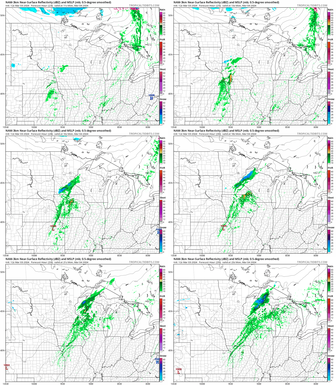
On Monday, the best chance of rain showers will be from southeastern Minnesota into Wisconsin. A passing shower is possible Monday morning in the Twin Cities metro area.
The National Oceanic and Atmospheric Administration’s North American Mesoscale Forecast System model shows the potential precipitation pattern from 5 a.m. Monday to 5 p.m. Monday:
Temperature trends
Monday highs will range from 20s in far northwestern Minnesota to lower 50s in the southeast:

A similar high temperature pattern is expected on Tuesday:

Twin Cities metro area highs retreat to the upper 40s for Wednesday and Thursday, followed by lower 40s on Friday. Next weekend is expected to feature metro area highs in the 40s.
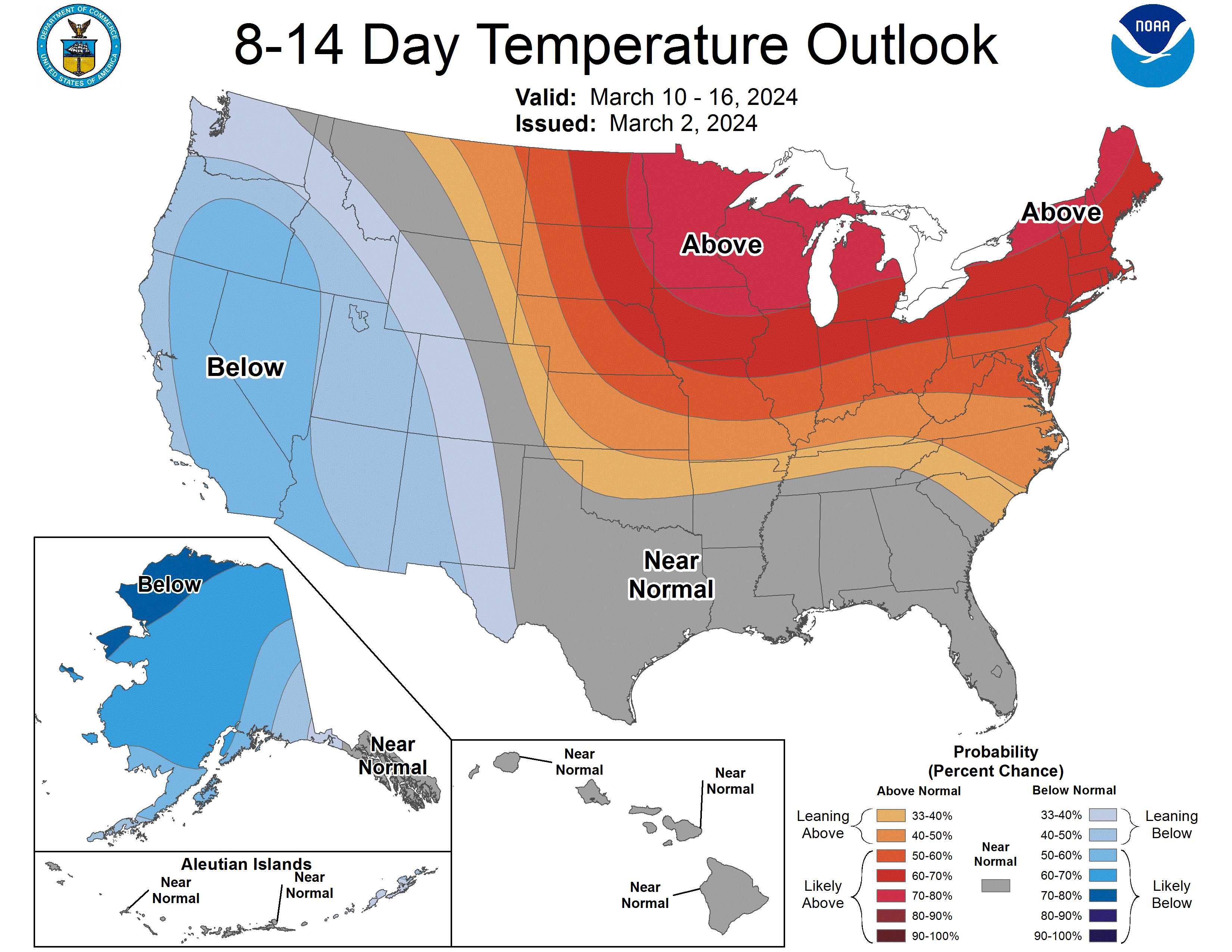
No big cold snaps are in sight. The March 10 to March 16 temperature outlook from the NWS Climate Prediction Center shows above-normal temperatures in Minnesota and Wisconsin:
Weather nugget
Twin Cities sunset is at 6:04 p.m. today. One week from today, we’ll be on daylight saving time, and the sun will set at 7:13 p.m. in the Twin Cities.
Programming note
You can hear my live weather updates on MPR News at 7:35 a.m., 9:35 a.m. and 4:39 p.m. each Saturday and Sunday.

