Storm system continues to impact Minnesota Tuesday

We’ll be chilly midweek before temperatures slowly warm up

haz 6a
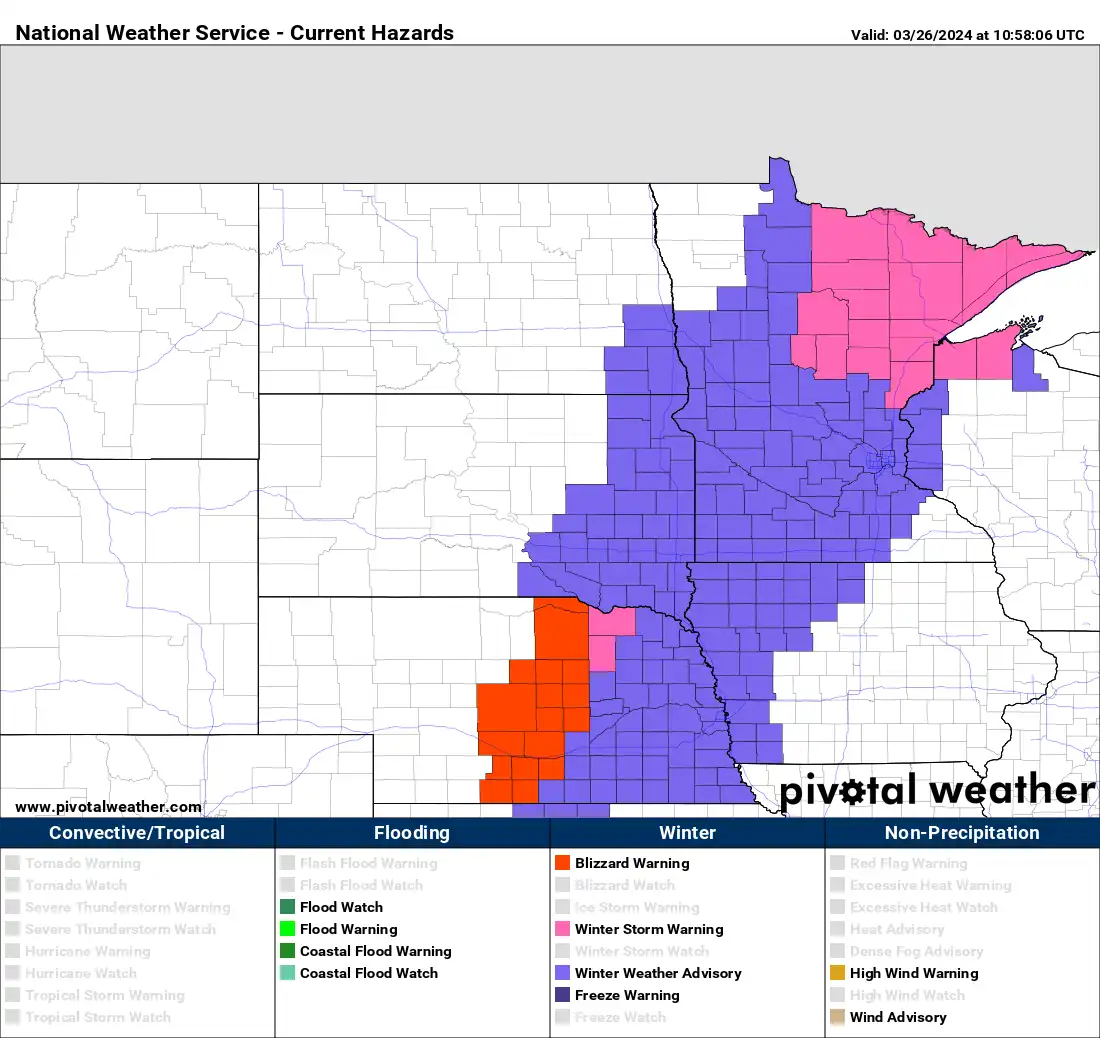
Winter weather advisories and winter storm warnings Tuesday
National Oceanic and Atmospheric Administration, via Pivotal Weather

Updated 11:25 a.m.

Colder air has dropped temperatures below freezing. We’ll see periods of snow much of the day Tuesday with temperatures that will continue to drop combined with gusty winds.

Temperatures drop with rain turning to snow Tuesday 

Colder air continues to sweep across Minnesota as our storm system starts to pull away. Temperatures will continue to drop throughout the day. 

temps TUE
Forecast temperatures 4 a.m. through 7 p.m. Tuesday
NOAA, via Pivotal Weather

Much of eastern Minnesota can expect additional snowfall accumulations. The most significant totals will be in northeast Minnesota.

addl snow 11a
Additional snowfall from 11 a.m. Tuesday through 2 a.m. Wednesday from NOAA's High Resolution Rapid Refresh model
NOAA via pivotal weather

Snow totals in Duluth and the North Shore are now over 16-21 inches in spots, so final totals could be more than 2 feet in some places from Duluth to Two Harbors and Silver Bay.

Create a More Connected Minnesota

MPR News is your trusted resource for the news you need. With your support, MPR News brings accessible, courageous journalism and authentic conversation to everyone - free of paywalls and barriers. Your gift makes a difference.

Gusty winds will continue Tuesday from the northwest at 15-30 mph with higher gusts in western Minnesota and along the North Shore.

tu-we winds
Forecast wind gusts 7 a.m. Tuesday through 12 p.m. Wednesday
College of DuPage Weather

Look for a cold night Tuesday night with most places falling into the teens. There will be a few single-digit lows in northeast Minnesota.  

tue nt lo 9a
Forecast lows Tuesday night
National Weather Service

Wind chill values will be subzero across northern and western Minnesota early Wednesday.

wed 7a chill
Forecast wind chills 7 a.m. Wednesday
National Weather Service

Temperatures will remain chilly Wednesday and Thursday. Highs Wednesday will stay subfreezing for most of the state.

wed hi 7a
Forecast highs Wednesday
National Weather Service

Temperatures will gradually warm up heading into the weekend, but we’ll have a couple days at least to enjoy the snow that has been otherwise lacking this winter. Highs should return to the 40s in southern Minnesota and 30s for the north by Friday. We also have a couple chances for rain and snow showers Friday and Sunday.  

Much needed moisture and its impact

This moisture, while sloppy, has been nothing short of an early spring miracle. Liquid equivalent precipitation values are closing in on 1-2 inches from Duluth through the Twin Cities and Rochester.

precip 48 hr
72 hour precipitation analysis (liquid equivalent)
NOAA, via Pivotal Weather

Prior to the snow and rain of the past several days, we were running 1-2 inches behind for precipitation year-to-date for many areas. Pictured below are 60-day precipitation anomalies (departure from normal) through March 21:

60 day precip deficits
60-day precipitation anomalies (departure from normal) before the snowfall and rainfalls of the last few days
WeatherBELL Analytics

It will be interesting to see Thursday morning’s drought monitor report as it will include most of the precipitation of the last several days through 7 a.m. Tuesday.