Much cooler and wetter Wednesday before sun returns Thursday
Next chance of showers develops late Friday
Go Deeper.
Create an account or log in to save stories.
Like this?
Thanks for liking this story! We have added it to a list of your favorite stories.
Wednesday will be much cooler with clouds and on and off scattered rain showers. Sunshine returns Thursday but temperatures will still be below normal. Late Friday brings the next chance of rain.
Much cooler Wednesday with scattered showers; sun is back Thursday
It’s been a wet 12 to 24 hours for much of eastern Minnesota and northwestern Wisconsin. The heaviest pockets of rainfall included the south Twin Cities metro area, where 1 to 4 inches of rain fell, and a stretch from Carlton County and the Duluth area into northwestern Wisconsin.
Parts of northwestern Wisconsin north of Gordon and Cable have seen 5 or more inches of rainfall.

We’ll continue to see steady rain across much of eastern Minnesota Wednesday through early afternoon along with lots of cloud cover as our slow moving frontal boundary continues to move south, combined with an upper-level disturbance.
Turn Up Your Support
MPR News helps you turn down the noise and build shared understanding. Turn up your support for this public resource and keep trusted journalism accessible to all.
Rain should taper off early to midafternoon.

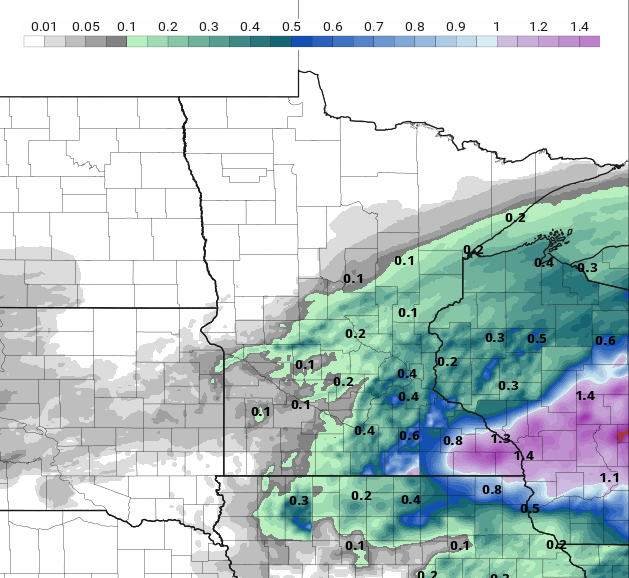
Additional rainfall Wednesday will generally be lighter than what most saw Tuesday and Tuesday night. An additional one-fifth of an inch to as much as 1 to 1.5 inches in southeastern Minnesota could fall.

It will be much cooler Wednesday with highs mostly in the 60s to low 70s across the state. Some places near Lake Superior will remain in the 50s.

Temperatures will be nearly 20 to 30 degrees cooler than 24 hours ago for a good chunk of Minnesota. These readings are unusually cool for mid-July, typically our hottest time of the year!

Dew points will drop by late Wednesday into the 50s and even 40s for northern Minnesota by Thursday afternoon.

That dry air will help to clear out the clouds and bring back sunshine Thursday. Highs Thursday will still be below normal but pleasant, in the 70s mostly.

The next chance of showers develops late Friday into Friday night. Most activity should move out for most of the state Saturday.

The weekend is shaping up be decent with sun by Saturday afternoon and Sunday and highs back close to 80 degrees.
Dear reader,
Your voice matters. And we want to hear it.
Will you help shape the future of Minnesota Public Radio by taking our short Listener Survey?
It only takes a few minutes, and your input helps us serve you better—whether it’s news, culture, or the conversations that matter most to Minnesotans.