Updraft® - Minnesota Weather News

Record lows tied as cool stretch continues

Summer heat returns next week
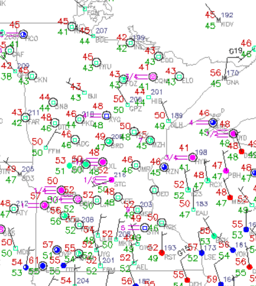
Chilly morning temperatures-July 17
Chilly morning temperatures Thursday
National Oceanic and Atmospheric Administration, via National Center for Atmospheric Research

If the latest weather has you craving pumpkin spice lattes and oversized sweaters, I hate to break it to you but it’s still mid-July. Enjoy the brief stretch of cooler days while they last. Summerlike warmth and humidity return next week.

Taste of early fall

We’re halfway through meteorological summer and there are still more chances for those sticky 90s in the forecast. But before the heat returns, we’re getting a brief taste of fall despite what the calendar says.

Early morning temperatures tied a record low of 52 degrees from 1976 in the Twin Cities. Up north, International Falls also matched its record low of 42 degrees originally set in 1918.

Chilly morning temperatures-July 17
NOAA, via National Center for Atmospheric Research

The average for July 17 is a high of 84 and a low of 66, so our recent temperatures have been running well below normal during the day and overnight.

Daily almanac for Minneapolis-St. Paul for July 17
Thursday's daily almanac for Minneapolis-St. Paul
NOAA Regional Climate Centers

The first couple weeks of July have taken us on a roller coaster of temperatures.

We kicked off the month with an early stretch of 90s, dipped into the 80s and upper 70s then climbed back into another round of 90-degree days. The latest drop into the 70s, paired with lows in the 50s, has brought a definite chill to the air.

14-day temperature recall
NOAA, via MesoWest-University of Utah

Our below average temperatures will continue through the upcoming weekend with highs expected in the 70s, near 80 degrees.

3-day forecast
3-day forecast
National Weather Service

Our next disturbance, moving down from the Canadian provinces, will push through the northern Plains and bring a chance for showers and storms mainly Friday afternoon and evening.

Forecast precipitation Friday 7 a.m. to Saturday 3 a.m.
NOAA, via Pivotal Weather

The National Oceanic and Atmospheric Administration’s Storm Prediction Center has issued a marginal risk for southern Minnesota with storms possible Friday afternoon into the evening. The main threats include heavy rain and strong winds.

Severe threat on Friday
NOAA Storm Prediction Center
Volume Button
Volume
Now Listening To Livestream
MPR News logo
On Air
All Things Considered with Mary Louise Kelly