Updraft® - Minnesota Weather News

September-like Thursday with more showers possible late Friday

Most of Saturday and Sunday should be dry, warm
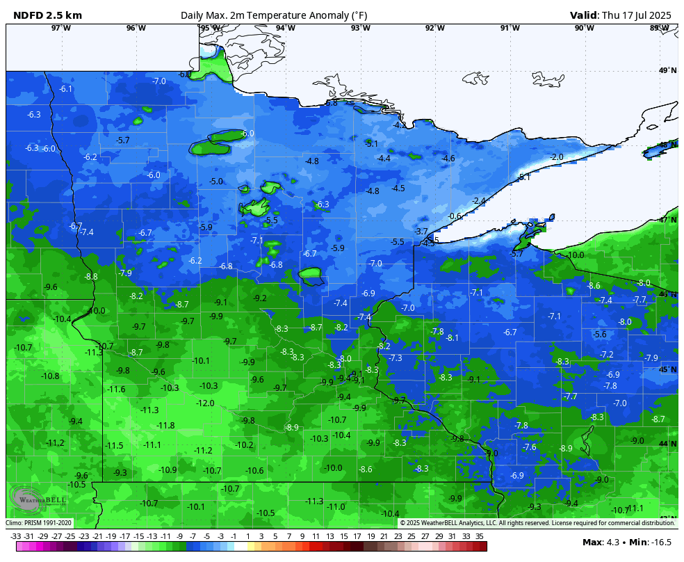
thu t anom
Forecast temperature anomalies (departure from normal) Thursday
WeatherBELL Analytics

We’ll have sunshine with below-normal temperatures and dew points Thursday. Showers are possible late Friday and Friday night before largely clearing out for Saturday and Sunday. 

September-like Thursday, then summer warmth returning 

It was downright cool for mid-July with early morning temperatures in the 40s and 50s before sunrise Thursday morning. The Twin Cities tied a record low of 52-degrees set back in 1976 and so did International Falls (42 set in 1918). This is only the third time since the year 2000 that the Twin Cities has been this cool or cooler in the month of July. In the 1990s alone we did so 16 times. It’s a staggering example of just how much summer nights have warmed in a generation.

MN LOWS
Temperatures at 5 a.m. early Thursday morning
SynopticData.com

We’ll have sunshine and afternoon highs in the low to mid-70s across the state. Those readings are 5 to 15 degrees cooler than normal for what should be hottest time of year.

thu 324
Forecast highs Thursday
National Weather Service

Clouds increase Friday and temperatures will again be in the 70s. The next disturbance will bring showers to northern Minnesota during the day with showers and storms developing for central and southern Minnesota in the midday, afternoon and evening hours into Friday night.

prec933
Forecast simulated radar 12 a.m. Friday through 7 a.m. Saturday
College of DuPage Weather

There’s even a marginal risk (level 1 of 5) of an isolated severe storm or two Friday across portions of southern Minnesota.

SPC FRI
Severe weather outlook Friday into Friday night
NOAA, via Iowa Environmental Mesonet of Iowa State University

The weekend is looking pretty nice with near-normal temperatures and sunshine Saturday afternoon and Sunday with mainly dry weather. 

wknd
Forecast highs Saturday (left) and Sunday (right)
National Weather Service

Things could be heating back up next week as Minnesota finds itself on the northern edge of a developing heat dome. Highs should be in the upper 80s to perhaps near 90 degrees again by midweek for at least central and southern Minnesota. 

500pattern
Forecast upper level pattern Sunday through Thursday
European Centre for Medium range Weather Forecasting via pivotal weather

Dear reader,

Your voice matters. And we want to hear it.

Will you help shape the future of Minnesota Public Radio by taking our short Listener Survey?

It only takes a few minutes, and your input helps us serve you better—whether it’s news, culture, or the conversations that matter most to Minnesotans.

Volume Button
Volume
Now Listening To Livestream
Headshot of 1A host Jenn White
On Air
1A with Jenn White