Updraft® - Minnesota Weather News

Rain and thunder chances return Friday ahead of a decent weekend

Next week heats up again

wx FRI
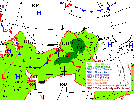
Forecast surface weather conditions late Friday
National Weather Service

Our next chance of rain and thunder develops Friday into Friday night. Clouds decrease Saturday with highs both Saturday and Sunday closer to 80 degrees again. 

Showers, thunder possible Friday into Friday night with decreasing clouds Saturday 

Temperatures will be below normal again Friday, mostly in the 70s, but just in the 60s for northern Minnesota where they’ll see more cloud cover and showers.

fri 946
Forecast highs Friday
National Weather Service

Our next disturbance is already developing showers and thunderstorms Friday morning in northern and western Minnesota. That chance increases statewide by later in the day Friday into Friday night.

Some storms in southwestern Minnesota could be strong to severe Friday afternoon and evening.

fri precip 943
Forecast simulated radar 9 a.m. Friday through 11 a.m. Saturday
National Oceanic and Atmospheric Administration, via Pivotal Weather

There’s a slight risk (level 2 of 5) for isolated severe storms in southwestern Minnesota. A marginal risk (level 1 of 5) is forecast elsewhere across central and southern Minnesota Friday into Friday night.

SPC Fri 946
Severe weather outlook Friday into Friday night
NOAA, via Iowa Environmental Mesonet of Iowa State University

Clouds should decrease Saturday with lots of sunshine Sunday. Highs will be closer to 80 degrees again for southern Minnesota, which is just a few degrees shy of normal. 

wknd 550
Forecast highs Saturday (left) and Sunday (right)
National Weather Service

Next week heats back up along with a return of humid air. We’ll be on the northern edge of a heat dome, which means we won’t see the real hot stuff. But highs in the upper 80s to near 90 degrees at time are very possible midweek.

tue hi Fo
Forecast highs Tuesday
NOAA, via Pivotal Weather

We’ll also see at least few chances at thunderstorms once again, especially in the overnight hours as we’ll be in a “ring of fire” pattern. Several fast-moving upper-level disturbances will touch off some thunder chances on that northern edge of the heat.

sun-thu EUR PREC
Forecast precipitation 7 p.m. Sunday through 7 p.m. Thursday
European Centre for Medium-Range Weather Forecasts, via Pivotal Weather

Dear reader,

Your voice matters. And we want to hear it.

Will you help shape the future of Minnesota Public Radio by taking our short Listener Survey?

It only takes a few minutes, and your input helps us serve you better—whether it’s news, culture, or the conversations that matter most to Minnesotans.

Volume Button
Volume
Now Listening To Livestream
MPR News logo
On Air
BBC World Service