Sunshine to wrap up the weekend with comfortable high temperatures
Air quality alert continues for northern Minnesota
Go Deeper.
Create an account or log in to save stories.
Like this?
Thanks for liking this story! We have added it to a list of your favorite stories.
The weekend wraps up on a bright note Sunday, with plenty of sunshine and comfortable highs in the upper 70s to near 80 degrees. However, an air quality alert remains in effect for northern Minnesota, where fine particle levels are reaching the very unhealthy category.
Smoky skies for northern Minnesota
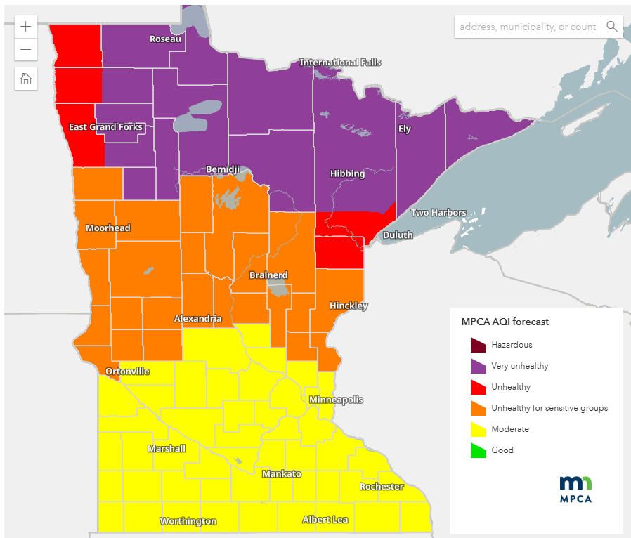
An air quality alert remains in effect until 9 a.m. Monday for the northern third of the state.

Fine particle levels are forecasted to reach the purple category, which is considered very unhealthy for everyone. Other areas are expected to reach the red and orange categories, indicating unhealthy conditions and unhealthy conditions for sensitive groups, respectively.
Turn Up Your Support
MPR News helps you turn down the noise and build shared understanding. Turn up your support for this public resource and keep trusted journalism accessible to all.

Check the latest air quality conditions, alerts and forecast here:
MPCA website Current air quality conditions
MPCA website: Air quality forecasts
Sunday will bring plenty of sunshine, with temperatures climbing into the upper 70s to around 80 degrees. Dew points will stay comfortable for now, but a surge of moisture is expected to return early in the week.

Monday brings a rinse-and-repeat forecast from Sunday, with similar temperatures in the upper 70s to near 80. The main difference will be rising dew points, gradually increasing from the south.

A heat dome will settle over the Central Plains this week, bringing hot and humid conditions to the state. While the most intense heat will remain to our south, many areas will still experience heat index values in the low 90s through much of the week.
There is a marginal risk for severe weather on Tuesday with storms expected in the afternoon and evening hours.

Tuesday’s rainfall amounts look impressive, with a slight risk of excessive rainfall in some areas of north central Minnesota.

Expect a classic “dog days of summer” pattern this week, featuring heat, humidity and nearly daily chances of thunderstorms.
Dear reader,
Your voice matters. And we want to hear it.
Will you help shape the future of Minnesota Public Radio by taking our short Listener Survey?
It only takes a few minutes, and your input helps us serve you better—whether it’s news, culture, or the conversations that matter most to Minnesotans.