Updraft® - Minnesota Weather News

A steamy and unsettled week with several thunder chances

Humid air arrives Tuesday for most

wx MON
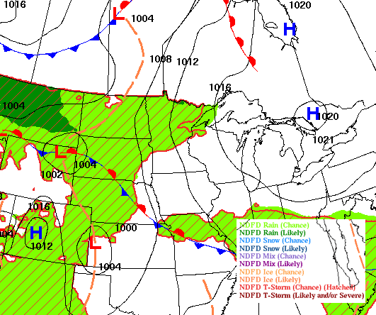
Forecast surface weather conditions late Monday
National Weather Service

Monday will start comfortable but most of the week will be very warm and humid. We’ll have several chances at thunderstorms with an unsettled pattern.

A very warm, humid and unsettled week 

Ongoing showers and storms will push across southern Minnesota Monday morning. These are leftover storms from South Dakota that were severe earlier. These storms could produce some isolated severe wind gusts over 60 mph. Most activity should not be severe Monday morning. We’ll then see decreasing clouds midday into the afternoon with an isolated or spotty thunderstorm or two possible.

precMON
Forecast simulated radar 6 a.m. through 9 p.m. Monday
NOAA via pivotal weather

Monday will be the last cooler day before steamy conditions move into the state for Tuesday and the rest of the week. Afternoon highs will be in the 70s to low 80s for most. 

mon
Forecast highs Monday
National Weather Service

More storms will be possible overnight in northwest and northern Minnesota into Tuesday morning. More widespread storms develop again late Tuesday into Tuesday night and late Wednesday into Wednesday night as a slow-moving cool front slides across Minnesota.

tue-thu
Forecast precipitation 4 a.m. Tuesday through 7 a.m. Thursday
European Centre for Medium range Weather Forecasting via pivotal weather

There’s a marginal risk of severe storms (level 1 of 5) for central and southern Minnesota Monday.

mon spc
Severe weather outlook Monday into Monday night
NOAA, via Iowa Environmental Mesonet of Iowa State University

There’s a slight risk (level 2 of 5) for severe storms in central and southern Minnesota Tuesday. 

spc TUE
Severe weather outlook Tuesday into Tuesday night
NOAA, via Iowa Environmental Mesonet of Iowa State University

Highs Tuesday and Wednesday will be in the upper 80s to near 90 degrees across southern Minnesota along with dew points that will increase from the 50s and 60s Monday into the more tropical 70s. 

dews
Forecast dew points 7 a.m. Monday through 7 p.m. Tuesday
College of DuPage Weather

Those dew points and temperatures near 90-degrees, combined, will create heat indices of 90 to 100-degrees across southern Minnesota both Tuesday and Wednesday.

tue index
Forecast heat index values Tuesday afternoon
National Weather Service

Temperatures will be slightly cooler briefly on Thursday before steamy air moves back in for the last weekend of July. 

Volume Button
Volume
Now Listening To Livestream
MPR News logo
On Air
Radiolab with Lulu Miller