
November storms in the Great Lakes: From the Edmund Fitzgerald to the latest
Unpredictable winds, temperature shifts define Great Lakes storms
Go Deeper.
Create an account or log in to save stories.
Like this?
Thanks for liking this story! We have added it to a list of your favorite stories.


Early to mid-November has a history of producing some of the most brutal storms in the Upper Midwest. During this time, lingering warmth clashes with incoming arctic air, creating volatile weather patterns that can shift from calm to catastrophic in a matter of hours.
From the deadly Armistice Day Blizzard of 1940 to modern-day storms in 1998 and 2022, Midwesterners have witnessed firsthand how quickly the season can turn.
The sinking of the Edmund Fitzgerald on Nov. 10, 1975 stands as a stark reminder that this volatility is not limited to the land, the Great Lakes can be just as deadly.
Extreme November storms
Early November is a month of transition. Lakes are still relatively warm, the land is cooling and arctic air is advancing.
Turn Up Your Support
MPR News helps you turn down the noise and build shared understanding. Turn up your support for this public resource and keep trusted journalism accessible to all.
When these air masses meet, the atmosphere can spin up powerful low-pressure systems that pack heavy snow, rain, ice and strong winds — sometimes all at once.
It’s no wonder this time of year has produced some of the most memorable storms in Minnesota and Great Lakes history.
Nov. 8–12, 2022 Great Lakes storm
Between Nov. 8 and Nov. 12, 2022, a powerful storm system swept across Minnesota and the western Great Lakes, bringing a remarkable mix of weather.
The storm produced rain, thunderstorms, strong winds, record humidity and unseasonably warm air followed by a rapid temperature crash. By the time it ended, parts of the state had seen ice, heavy snow and even blizzard conditions.
In southern Minnesota, temperatures surged from 37 degrees on Nov. 7 to 68 degrees on Nov. 10, with record-high dew points of 60 and 61 degrees, the latest such readings ever recorded. Then temperatures plunged more than 40 degrees in 12 hours, dropping into the 20s by the evening of Nov. 12.
While the south saw rain and warmth, northwestern Minnesota faced the season’s first blizzard. Warroad recorded 9.1 inches of snow, with 7 to 9 inches in nearby towns. By the storm’s end, much of northern Minnesota was blanketed in several inches of snow.
From Nov. 8–12, Community Collaborative Rain, Hail and Snow Network observers around Duluth and between Big Lake and Princeton measured 3 inches or more of precipitation, roughly double the normal monthly total.
The highest official total was 3.05 inches in Floodwood, in St. Louis County, with other notable amounts including 2.69 inches in Duluth and 1.64 in St. Cloud.

Nov. 10–11, 1998: The Veterans Day Storm
Just a few decades earlier, another powerful November system took aim at Minnesota and the Great Lakes region. Between Nov. 10-11, 1998, a deep low-pressure system unleashed a combination of record rainfall, fierce winds and blizzard conditions across the state.
In Duluth, the storm delivered 2.26 inches of rain, setting a new daily rainfall record. Meanwhile, in the Twin Cities, the barometer dropped to 28.55 inches — or 966 mb — the lowest atmospheric pressure ever recorded there.
As the system intensified, west winds tore across Minnesota, gusting to 64 mph in St. Cloud, 62 mph in Mankato, and 61 mph in Madison and New Ulm.
Farther west, the rain quickly changed to heavy snow as cold air wrapped around the deepening low. Canby reported 13.5 inches. Madison received 10 inches. Staples and Montevideo measured 8 inches.
The heavy snow and strong winds produced whiteout conditions that shut down travel across much of western Minnesota.

Nov. 11–12, 1940: The Armistice Day Blizzard
The most infamous early November storm in Minnesota history struck on Nov. 11–12, 1940, a devastating event now remembered as the Armistice Day Blizzard.
What began as a mild, almost springlike day quickly turned deadly as an intense low-pressure system exploded over the Upper Midwest.
Temperatures that started in the 50s plummeted more than 40 degrees in just a few hours as howling winds swept in blinding snow and ice. Rain turned to sleet and then to heavy snow, paralyzing travel and trapping hunters, travelers and residents across the region.
The storm claimed 154 lives across the Midwest, including hunters caught off guard by the sudden shift in weather. Snowfall totals were staggering, 16.2 inches at the Twin Cities airport and a remarkable 26.6 inches at Collegeville. Winds gusted over 60 mph, creating massive drifts and near-zero visibility.
The Armistice Day Blizzard remains one of the deadliest and most dramatic weather events in Minnesota history.

Nov. 9–11, 1975: The Edmund Fitzgerald storm
One of the most powerful and haunting storms in Great Lakes history struck between Nov. 9-11, 1975, when a deep and fast-moving low-pressure system swept across the region.
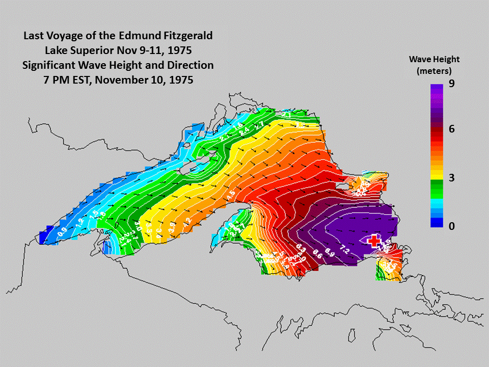
Known today as the Edmund Fitzgerald storm, it unleashed hurricane-force winds, towering waves, freezing rain, and intense snow squalls, conditions that led to the tragic sinking of the Edmund Fitzgerald on Lake Superior.
The storm began as a developing low-pressure system over the southern plains on Nov. 9. As it raced northeast toward the Great Lakes, it deepened explosively, with its central pressure dropping below 982 mb by Nov. 10.
This rapid intensification produced sustained winds of 50-60 mph and gusts up to 86 mph, equivalent to a category 2 hurricane.
By the evening of Nov. 10, the Edmund Fitzgerald was battling giant waves averaging 25 feet, with some estimates of rogue waves exceeding 35 feet. Minutes later, the Fitzgerald vanished from radar near Whitefish Bay, taking all 29 crew members with her. The storm continued into Nov. 11, bringing snow, intense winds and widespread damage across the Great Lakes.
The Edmund Fitzgerald storm remains one of the most powerful and tragic weather events in Great Lakes history. Its legacy spurred significant advancements in marine forecasting.
Advances in Great Lakes forecasting
Over the past 50 years, forecasting on the Great Lakes has advanced dramatically. Modern meteorologists now rely on a network of satellites, radars, and automated buoys to track wind, waves, and weather in real time.
High-resolution computer models and data analysis allow forecasters to predict storms with far greater accuracy and lead time than was possible in the 1970s.
In 1975, the Open Lake Forecast, which is a specialized weather forecast issued for the open waters of the Great Lakes, covered just 24 hours, with a single daily synopsis for both Lake Superior and Lake Michigan.
Today, each lake has its own detailed forecast for multiple zones, including custom weather, wind, and wave predictions up to five days in advance.

Remembering the past, respecting the weather
The Armistice Day Blizzard, the loss of the Edmund Fitzgerald, and the storms of 1998 and 2022 all highlight a single truth: November weather across the Upper Midwest is as unpredictable as it is powerful.
By remembering these events, we ensure that the knowledge gained from the past continues to guide us through future storms.

