
Blizzard warnings upgraded as major snowstorm targets the Twin Cities
45 to 55 mph wind gusts could create near-blizzard travel conditions

Go Deeper.
Create an account or log in to save stories.
Like this?
Thanks for liking this story! We have added it to a list of your favorite stories.


A powerful winter storm is set to slam the Twin Cities this weekend, prompting blizzard warnings for parts of central and southern Minnesota as heavy snow and wind gusts over 50 mph threaten dangerous travel.
Blizzard warning issued as powerful winter storm targets Minnesota and Wisconsin
A historic and powerful winter storm expected to bring heavy snow and strong winds this weekend has been upgraded to a blizzard warning, bringing the potential for extremely dangerous travel conditions.
Here’s the latest from the National Weather Service on this potent storm system:
URGENT - WINTER WEATHER MESSAGE National Weather Service Twin Cities/Chanhassen MN 108 PM CDT Sat Mar 14 2026 ...HISTORIC MARCH WINTER STORM ON TRACK TO BRING EXTREME SNOW ACCUMULATIONS AND STRONG WINDS... ...A WINTRY MIX OF RAIN, FREEZING RAIN, AND SLEET LATE TONIGHT ACROSS SOUTH CENTRAL MINNESOTA... ...TRAVEL MAY BECOME IMPOSSIBLE LATE TONIGHT AND SUNDAY... .A historic March winter storm will move across the Upper Midwest starting this evening and lasting into Sunday night. Heavy snow with a broad area of 12 to 18 inches expected across central Minnesota and western Wisconsin. A narrow swath within the broader area may approach 2 feet in parts of far east central Minnesota and west central Wisconsin. Rates of 2 to 2.5 inches per hour are likely late tonight into Sunday morning. A wintry mix of rain, freezing rain, and sleet is expected to work north into I-90 corridor of southern Minnesota tonight. A half inch of sleet and a tenth of an inch of ice are expected along the I-90 corridor. The wintry mix will turn to all snow Sunday morning. Winds will increase on Sunday. Even though the snow will be tapering off gradually throughout Sunday, northwest winds will increase to 35 to 45 mph. Some gusts of 50 to 55 mph are possible across the Minnesota River Valley. The combination of falling snow, blowing snow, and gusty winds will reduce visibility and create blizzard conditions late tonight through Sunday evening across central and southern Minnesota and western Wisconsin. Travel is expected to become very difficult or impossible late tonight through Sunday evening. In addition, the amount of water in the snowpack will make it very heavy, leading to the potential for infrastructure damage and a health hazard for those shoveling.
The latest projected snowfall totals continue to show a heavy swath of snow from central and eastern Minnesota into western Wisconsin. Many areas could receive around a foot of new snow, with localized pockets potentially nearing two feet.
Turn Up Your Support
MPR News helps you turn down the noise and build shared understanding. Turn up your support for this public resource and keep trusted journalism accessible to all.

As the storm strengthens overnight Saturday, snowfall rates are expected to intensify across parts of the region. Bands of heavy snow could produce two to three inches per hour late Saturday night into early Sunday, with the heaviest snow bands expected after 10 p.m. and continuing into the early morning hours Sunday.
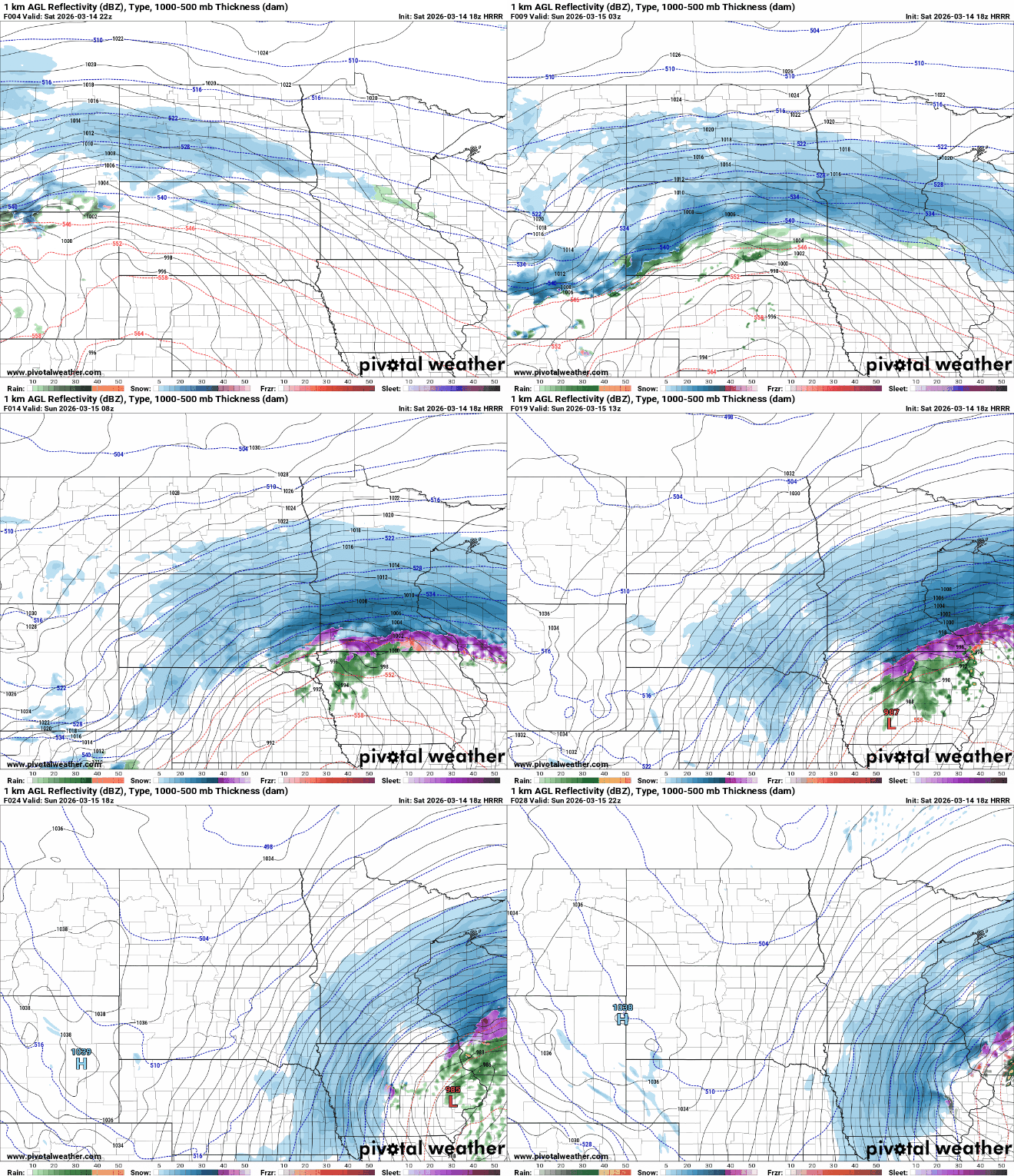
These intense bursts of snow will likely lead to rapidly deteriorating road conditions and sharply reduced visibility, especially as strong winds begin to develop. In some locations, thunder and lightning may accompany the heaviest snow bands. Forecast models indicate wind gusts could exceed 50 mph across southern Minnesota.
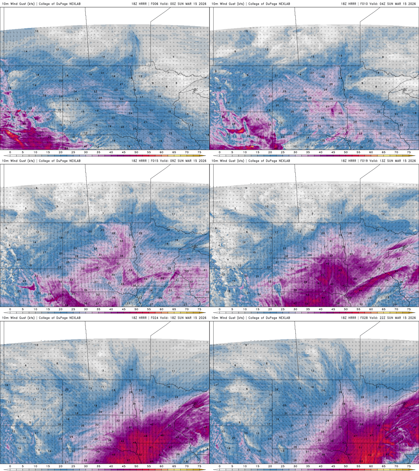
The National Weather Service is warning about the dangers of traveling during the storm and the health risks associated with shoveling heavy snow:
Travel is expected to become very difficult or impossible late tonight through Sunday evening. In addition, the amount of water in the snowpack will make it very heavy, leading to the potential for infrastructure damage and a health hazard for those shoveling.
Snowfall is expected to continue through Sunday before tapering from west to east, lingering in western Wisconsin into early Monday.

