
Major March storm brings blizzard conditions and dangerous travel
Heavy snow with 50-60 mph winds expected Sunday

Go Deeper.
Create an account or log in to save stories.
Like this?
Thanks for liking this story! We have added it to a list of your favorite stories.


Blizzard conditions continue to develop across central and southern Minnesota as a powerful late-season storm produces intense snowfall rates and powerful wind gusts approaching 60 mph, creating dangerous travel conditions.
Blizzard conditions develop amid heavy snow and hazardous travel
Our powerful late-season snowstorm continues to hammer the southern half of Minnesota this morning. Early snowfall reports are already showing just how intense these snow bands have been. Rochester has reported 11 inches of snow, while Mankato and Owatonna have picked up around 9 inches. Closer to the Twin Cities, the southern metro has already seen totals near 10 inches, with more snow still falling.
The center of the storm system early Sunday morning is located over central Kansas and is tracking northeast toward eastern Iowa. As the system strengthens and tilts, the northwestern side of the storm, which is typically the heaviest snow region, will sit directly over southern Minnesota and western Wisconsin.
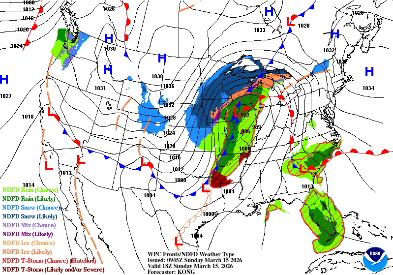
As the system moves east, it will continue to intensify and bring very gusty winds of 50-60 mph, creating blizzard conditions across southern Minnesota. These increasing winds will lead to widespread blowing and drifting snow, significantly reducing visibility and making travel extremely dangerous. Blizzard warnings remain in effect for the southern half of the state through Monday morning.
Turn Up Your Support
MPR News helps you turn down the noise and build shared understanding. Turn up your support for this public resource and keep trusted journalism accessible to all.

Snow will continue to fall through the day, bringing another 4-8 inches to the Twin Cities and communities along Interstate 90. Meanwhile, southeastern Minnesota and western Wisconsin are positioned under the storm’s most intense snow band, where an additional 10-12 inches or more is possible.
The heaviest snow will ease up Sunday afternoon, but strong winds will continue to blow snow around into Monday, leading to a messy and slow Monday morning commute.

Arctic air follows the storm
Temperatures on Sunday will stay in the 20s and 30s before a brief burst of Arctic air moves in at the start of the workweek.

Lows Sunday night are expected to drop into the single digits, both above and below zero.

With winds still gusting around 30–40 mph, wind chills Monday morning could make it feel like the teens and 20s below zero.

A smaller system is expected to move in Tuesday evening into early Wednesday, bringing the potential for a few additional inches of snow. Once that system passes, temperatures will warm up significantly, with highs climbing back above freezing.

