
Sunday storm threat; severe weather potential Sunday and Monday
Cooler temperatures expected midweek

Go Deeper.
Create an account or log in to save stories.
Like this?
Thanks for liking this story! We have added it to a list of your favorite stories.


After a warm and quiet stretch, the weather pattern is turning much more active across Minnesota today with multiple rounds of showers and thunderstorms expected through Monday.
Some of tonight’s storms could become severe, especially across southern Minnesota, while much of the region is also set to receive its first widespread soaking rainfall of the month.
Severe weather returns Sunday night
Cloud cover will blanket the region on Sunday as more humid air returns, with dew points rising into the upper 50s to low 60s across southern Minnesota. Temperatures will stay mild in the southern half of the state, reaching the 70s to low 80s, while northern Minnesota remains cooler in the 50s and 60s.

Moisture streaming in from the Gulf will help fuel rounds of thunderstorms, bringing periods of beneficial rainfall from Sunday into Monday.
Turn Up Your Support
MPR News helps you turn down the noise and build shared understanding. Turn up your support for this public resource and keep trusted journalism accessible to all.
Storms are expected to erupt late Sunday afternoon across the eastern Dakotas near a strengthening surface low tracking toward Minnesota and Wisconsin.
Southwestern and southern Minnesota will be most favorable for severe weather development, prompting the Storm Prediction Center to place southwestern Minnesota under an enhanced risk (level 3 of 5) for severe storms, with a slight risk covering much of southern Minnesota.
Thunderstorms are expected to rapidly develop across Nebraska and the eastern Dakotas late this afternoon before advancing eastward into Minnesota during the evening. Current timing brings storms into western Minnesota between 6 and 8 p.m.; central Minnesota and the Twin Cities between 9 and 11 p.m.; and western Wisconsin during the overnight hours.
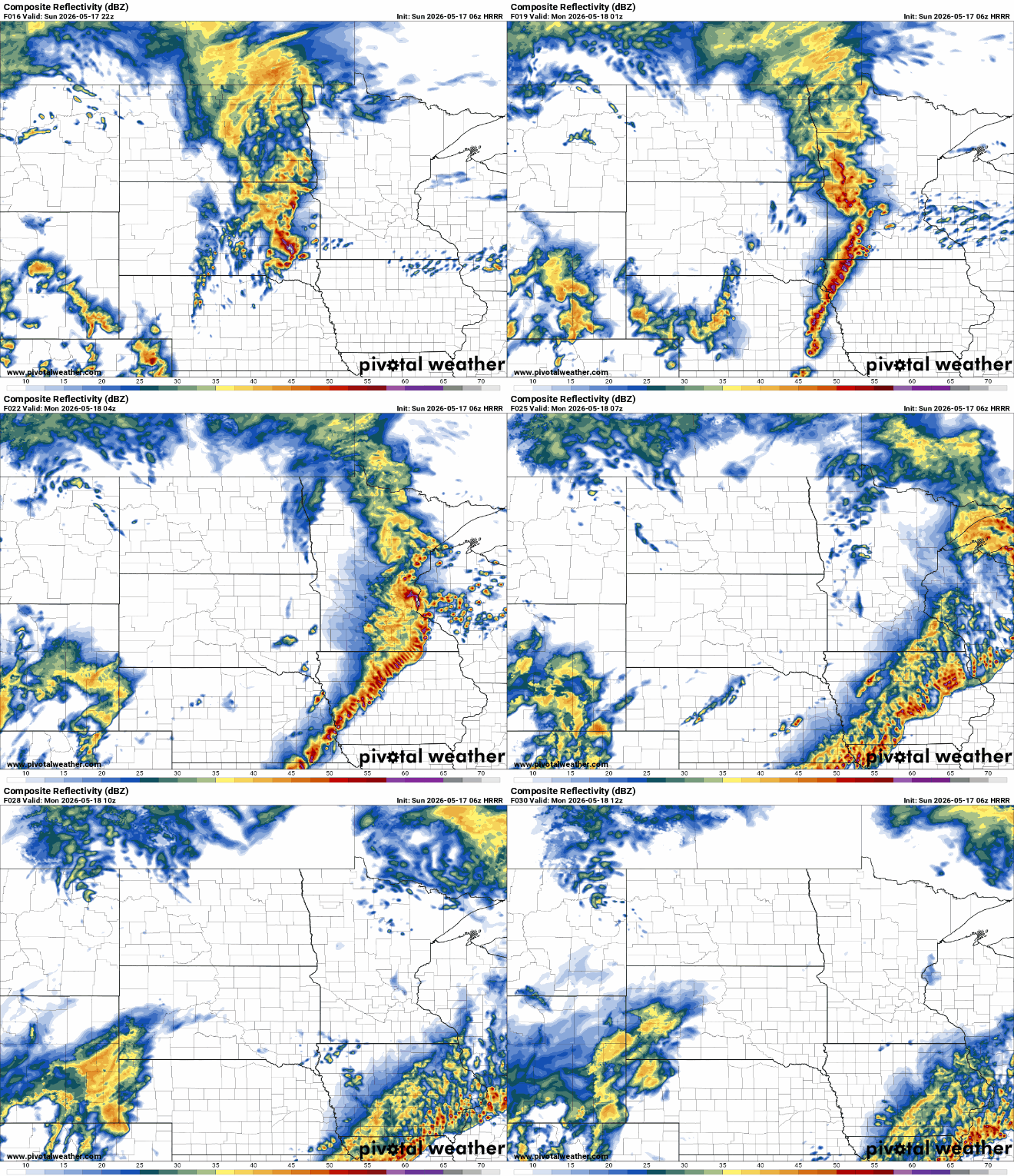
Early storms may become discrete rotating supercells capable of producing all modes of severe weather, including very large hail up to 2-3 inches in diameter, damaging wind gusts and a few tornadoes.

As storms push farther east Sunday night, they are expected to consolidate into one or more lines of thunderstorms. Once that occurs, damaging straight-line winds will likely become the main threat, though isolated tornadoes may still develop within the line of storms.
Monday itself may stay mostly dry for much of the day, but another round of showers and thunderstorms is expected to develop by late afternoon and continue into the evening hours. At this time, the greater severe weather threat on Monday appears to be shifting farther south and east, primarily impacting Iowa and Wisconsin.

In addition to the severe weather potential, this stretch of active weather will bring the first widespread soaking rainfall many areas have seen in weeks. Combined rainfall totals from Sunday night through Monday night are expected to reach 1-2 inches across much of the region, with localized amounts of 3 to perhaps 4 inches possible where thunderstorms repeatedly move over the same areas.

Highs on Monday will vary widely across Minnesota, ranging from the low 50s in the northwest to the low 80s in the southwest.

By Tuesday, cooler and drier weather settles back across the Upper Midwest. Additional chances for showers and thunderstorms arrive again by Friday and could continue into portions of the Memorial Day weekend.

