
NE Minnesota posts worst U.S. air quality; more heat coming
Little chance of significant rain
Go Deeper.
Create an account or log in to save stories.
Like this?
Thanks for liking this story! We have added it to a list of your favorite stories.


Following the worst day of heat in Boundary Waters history, the air quality from wildfire smoke is worsening. A minimum of nine thermometers spread throughout the broader Boundary Waters area reached 100 degrees, which is simply unheard of.
An update on smoke and wildfires
Fires underwent explosive growth on Monday, too. Take the Camp Fire. It was deemed so well taken care of a couple of days ago that it was deleted from some registries.
The fire came back and went from 40 acres in size Monday to 1,500 acres in just a matter of hours. Now, it is approaching 2,200 acres and evacuations have been ordered.

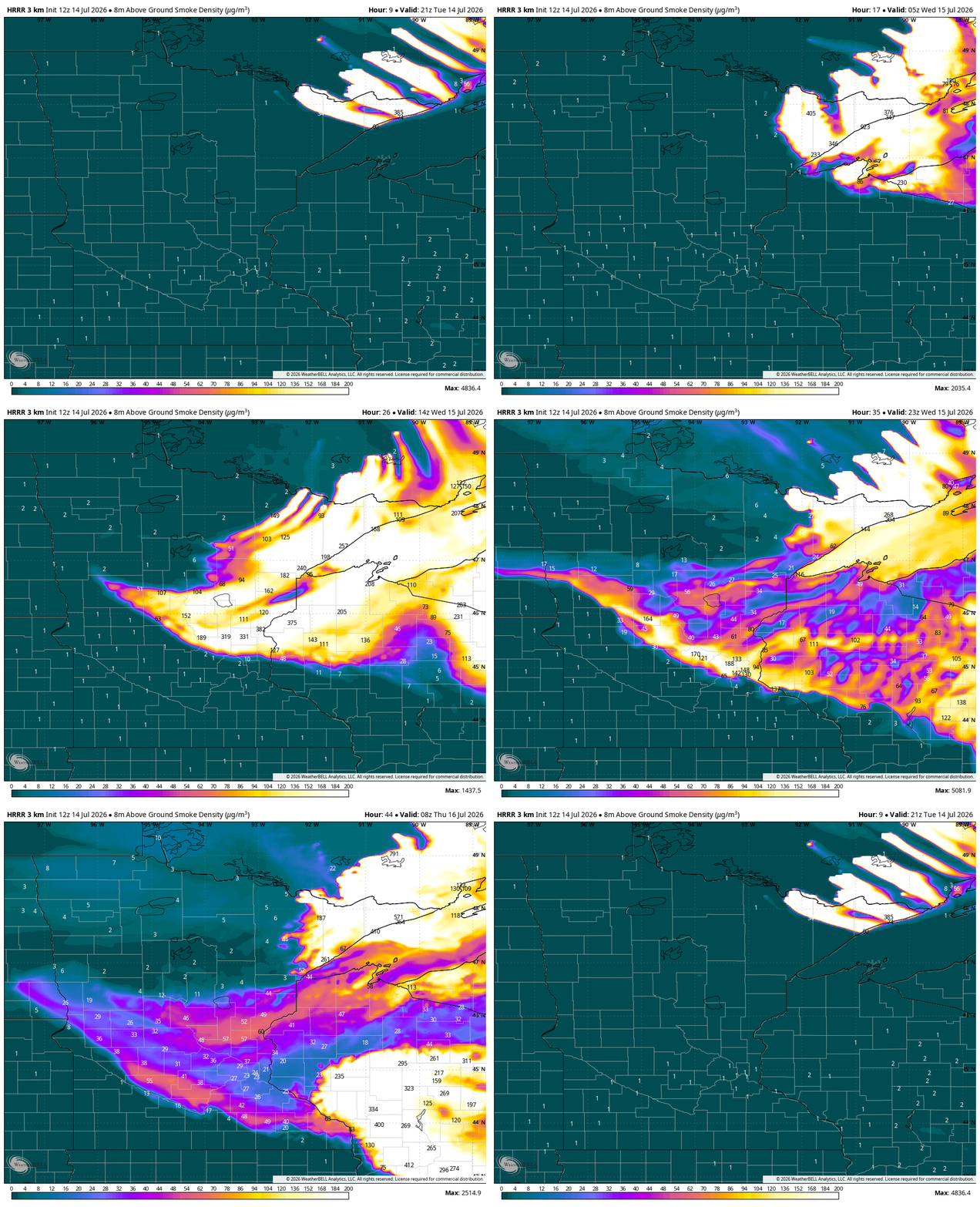
Tuesday may not be quite as hot in the Boundary Waters. However, smoke is building up around the North Shore. As of 11 a.m. Tuesday, Grand Portage has the worst air quality in all of the U.S.
Turn Up Your Support
MPR News helps you turn down the noise and build shared understanding. Turn up your support for this public resource and keep trusted journalism accessible to all.
Things are likely going to decline in other parts of the Arrowhead by Tuesday evening, especially around Ely and Duluth.
Fires are also likely to grow. A Canadian firefighting index, along with the FWI (Fire Weather Index) are both degrading through the day Tuesday as temperatures jump and dew points remain low.
Sunday and Monday saw notable spikes in smoke activity as fire grew by thousands of acres cumulatively. That, to some extent, is likely to continue in the next few days if wildland fire crews cannot get containment.


From Tuesday into Wednesday, wildfire smoke at the surface will curl around and should be noticeable in the Interstate 35 corridors, even in the Twin Cities. It is hard to say at this point if things will be as bad as 2025’s smoke, caused by Canadian wildfires.
What to expect with heat
As of late morning, many spots are racing for the 90s. The heat, coupled with ultra-low humidity in the Boundary Waters, is making firefighting challenging for several reasons: drier fuels, exhausted firefighters, water drops, etc.
All across the state, we expect highs in the 90s through at a minimum, Thursday and continuing in most places through the weekend. With some rain ahead this weekend, the northern third of Minnesota may end up in the lower 80s for a time.
Do not expect a relief to the heat anytime immediately soon. Lows overnight will also be in the low to mid-70s.
Rain stays away, mostly
For most of Minnesota, rain chances are exceptionally fleeting. That said, a tiny boundary has stayed hidden until noon on Tuesday.
Normally this would just be a very brief mention. But, because there is limited lightning over the remote Boundary Waters, there is concern among weather folks that this could spark a new wildfire in the backcountry.
Because the low-level air under these storms is so bone dry, there’s also a risk of accelerating downdraft winds that could fan the existing flames into fast-spreading fire behavior.
There could be a few showers Wednesday evening but only for the Canadian border country, running parallel to Minnesota’s border.
There could be a bit more helpful rain rolling in Friday to Saturday, again only for the northern districts. The signs pointing to weekend rain for the rest of the state, including Minneapolis and St. Paul, look more remote now.
Looking farther ahead, the next best chance for central Minnesota is probably next Monday. The next shot farther south may not be until next Thursday or Friday.


