
Record smoke levels north, high heat south across Minnesota
Widespread rain not on the way until at least Saturday
Go Deeper.
Create an account or log in to save stories.
Like this?
Thanks for liking this story! We have added it to a list of your favorite stories.


Wildfire smoke, wind and heat are dominating Minnesota’s weather right now. Here’s an update on the status of those conditions, along with the possibility of rain.
Smoke
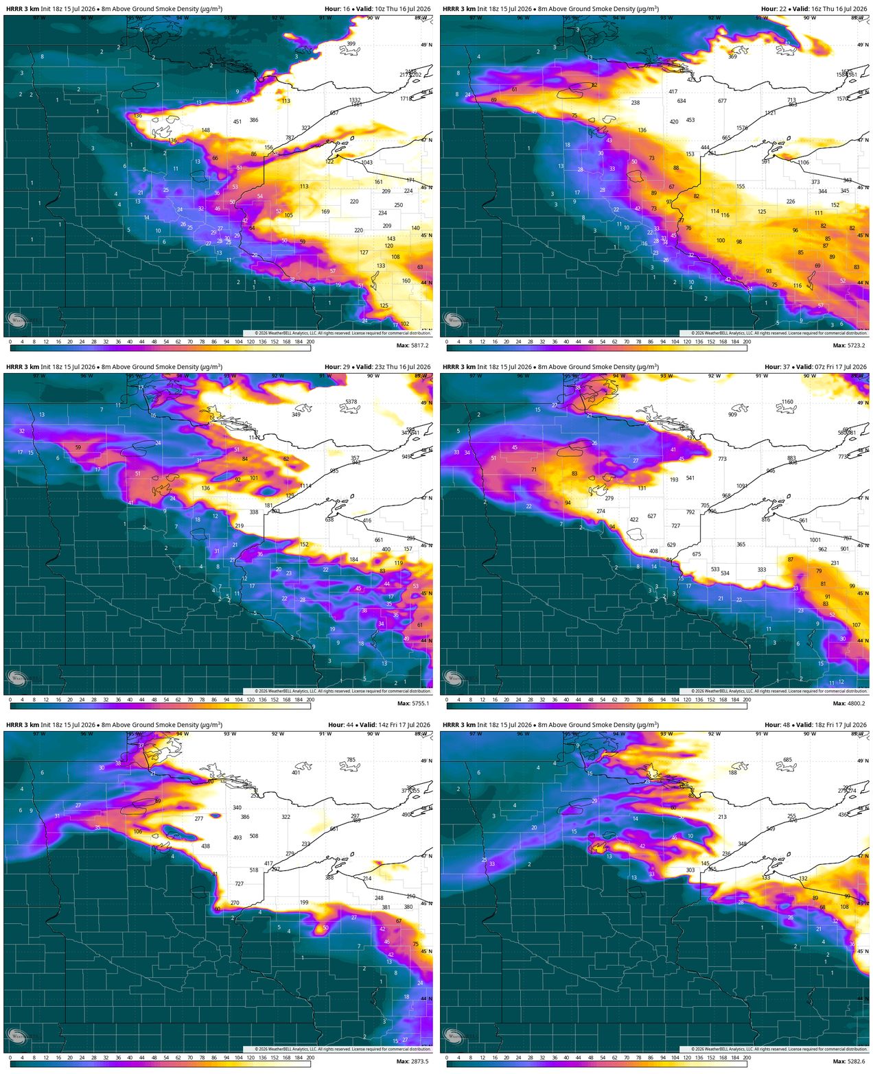
The current smoke levels are extremely dangerous for human health and will continue to be an issue. Minnesota repeatedly broke its record for worst air quality on Wednesday.
The Minnesota Pollution Control Agency’s air quality monitor in West Duluth went to nearly 1,000 for its hourly reading, which blasts past the “hazardous” category into new territory for the state.
The smoke is nearly stagnant because of the heat dome pattern, so it’s just sitting over the North Shore of Lake Superior. Slightly different fires in Canada are driving the smoke toward Ohio and Massachusetts, where you’ll hear more about it on the national news.
Turn Up Your Support
MPR News helps you turn down the noise and build shared understanding. Turn up your support for this public resource and keep trusted journalism accessible to all.

Up next, the smoke slowly moves south toward the Interstate 35 corridor, inching closer to the northern suburbs of the Twin Cities. This could then turn back to the northwest late Wednesday, pushing the smoke plume into central Minnesota and back over the Boundary Waters.
The Minnesota Pollution Control Agency updated its air quality alert through Friday, widening the range of hazardous air in central and northeastern Minnesota and putting the Twin Cities into the “very unhealthy” category.
Here are the latest updates to the air quality alert, with some expansions and upgrades, still valid through 11am Friday. See https://t.co/oEvwCgEJvz for more details. #mnwx #aqi pic.twitter.com/RWWquFa4a4
— MN Air Quality Index (@mpca_aqi) July 15, 2026
Rain
We do have a little rain in the far north of Minnesota late Wednesday morning but not enough to douse the smoke or shift the winds. Little of this will reach the ground and it certainly will not kill any fires. But the added humidity may slow the spread of fire for a brief time.
There is a tiny window for rain in the Twin Cities on Wednesday between 4 p.m. and 6 p.m.

There will be a few rain showers Thursday and Friday in the far north, along the Minnesota-Canada border.
The storm track could start to change on Saturday. The best chance of rain Saturday ranges from Duluth south along the 35 corridor and then parallel to the Mississippi River. The western half of the state has very little chance of rain.
We then wait for Monday’s front to pass south, which theoretically could bring the best widespread chance of rain in a week-and-a-half. If we don’t get rain then, we may need to wait until next Friday for a widespread round of rain.
Heat
Some spots in the north will be cooler. With all the smoke, the solar insolation isn’t as strong, and that will hold down temperatures.
The air temperature in the Boundary Waters stands at around 70 degrees Wednesday afternoon, even though the Twin Cities are in the 90s already. Some of this is from smoke, some from clouds and a more humid air mass up north.
Places like Duluth could briefly get into the lower 80s the next few days but only if the smoke clears somewhat. If not, they’ll top out in the 70s along the Lake Superior shore.
The heat is strongest in the southern half of Minnesota. We should easily reach the 90s, probably even mid-90s, through Friday. From there on to Monday, we will be close to 90.

Winds
There’s a boundary over the BWCA on Wednesday that is stifling gusts. That’s better news because the winds that drive fires forward are weaker now, compared to earlier in the week.
The lack of wind is also causing the smoke to sit still, effectively clogging Minnesota’s north with hazardous smoke levels. The winds will be light, out of the east, moving west, through at least early Friday.
On Friday, a weaker low-pressure system moves into northern Minnesota and then onto western Wisconsin.
By later Saturday and into next week, we get some stronger steering winds from northwestern Canada up in the clouds level.
Our hope is that the smoke will really blow out of our local region by later Saturday. That sets up a recurring northwest flow pattern into next week. That could bring rain, which could also help with smoke.

