
Dangerous wildfire smoke, record poor air quality choke Minnesota
Air quality alert continues through Friday

Go Deeper.
Create an account or log in to save stories.
Like this?
Thanks for liking this story! We have added it to a list of your favorite stories.


Wildfire smoke has once again become the dominant weather story across Minnesota, with air quality rapidly deteriorating to dangerous levels across much of the state.
Smoke from large wildfires in northeastern Minnesota and southern Canada has settled in, sending fine particle concentrations soaring and pushing many locations into the highest categories on the air quality index.
Air quality alert continues
The sky may look hazy but the bigger concern is what you can't see.
A thick plume of wildfire smoke has pushed air quality across much of Minnesota into unhealthy and hazardous territory, with some monitoring sites recording some of the worst conditions seen in recent years.
Turn Up Your Support
MPR News helps you turn down the noise and build shared understanding. Turn up your support for this public resource and keep trusted journalism accessible to all.
An air quality alert remains in effect through 11 a.m. Friday for nearly the entire state, with the most dangerous conditions expected across central, northern and northeastern Minnesota.
Areas farther west and northwest are expected to see very unhealthy (purple) conditions, while portions of western and southeastern Minnesota remain in the unhealthy (red) category.
Air quality has deteriorated rapidly
Just as a reminder, the air quality index is a scale used by the Environmental Protection Agency to describe how clean or polluted the air is and what health effects people can expect.
Air quality alerts continue for much of Minnesota Thursday and Friday due to wildfire smoke.
Check the latest air quality conditions, alerts and forecasts here:
Under normal summer conditions in Minnesota, air quality index values typically range between 20 and 50, which falls in the good air category.
During this smoke event, many communities have seen readings climb well above 300, with some monitoring sites briefly approaching or even exceeding 1,000.

Several monitoring sites have already reached hazardous (maroon) levels, the worst category and one where the air poses health risks to everyone, not just sensitive groups.

The graphic below shows just how quickly conditions deteriorated at the Hibbing monitoring site on Minnesota’s Iron Range.
Fine particulate matter concentrations (PM 2.5) shot above 800 µg/m³ (micrograms per cubic meter of air). Readings above 225.5 µg/m³ are considered hazardous, highlighting the extreme level of smoke impacting the region.

What was relatively clean air just a few days ago has rapidly climbed into the hazardous category as dense smoke settled over the region.
The Twin Cities have experienced an equally dramatic increase. Air quality readings climbed rapidly Wednesday evening and overnight, reaching levels rarely observed in Minnesota.
At times, fine particulate matter concentrations have exceeded previous records, making this one of the most significant smoke events. Ely set a new record with a PM2.5 concentration of 797 µg/m³, while Blaine in the Twin Cities recorded a new record of 342.8 µg/m³.

How long will the wildfire smoke last
The good news is that relief is on the way. The bad news? Exactly when the smoke clears is incredibly difficult to predict.
According to Matt Taraldsen, supervisory meteorologist with the Minnesota Pollution Control Agency, forecasting wildfire smoke is especially challenging because it's a combination of weather and atmospheric chemistry.
Weather models have their own uncertainties, and smoke models rely on those forecasts while also trying to account for how much smoke is being produced and where it will travel. As Taraldsen explained, much of the data used to forecast wildfire smoke takes time to become available. Satellites detect the heat from active fires and estimate smoke production from those observations, but that process can take several hours.
When a wildfire grows rapidly, the smoke models may still be using an outdated fire footprint. As a result, forecasts can underestimate both the amount of smoke being produced and where the thickest smoke will ultimately travel.
A cold front will move across Minnesota Friday, bringing in northwest winds that will help push out some of the smoke and bring cleaner air into the state.
Air quality should gradually improve from northwest to southeast through the day, although areas closest to the ongoing wildfires, especially northeastern Minnesota, could continue to see lingering smoke.
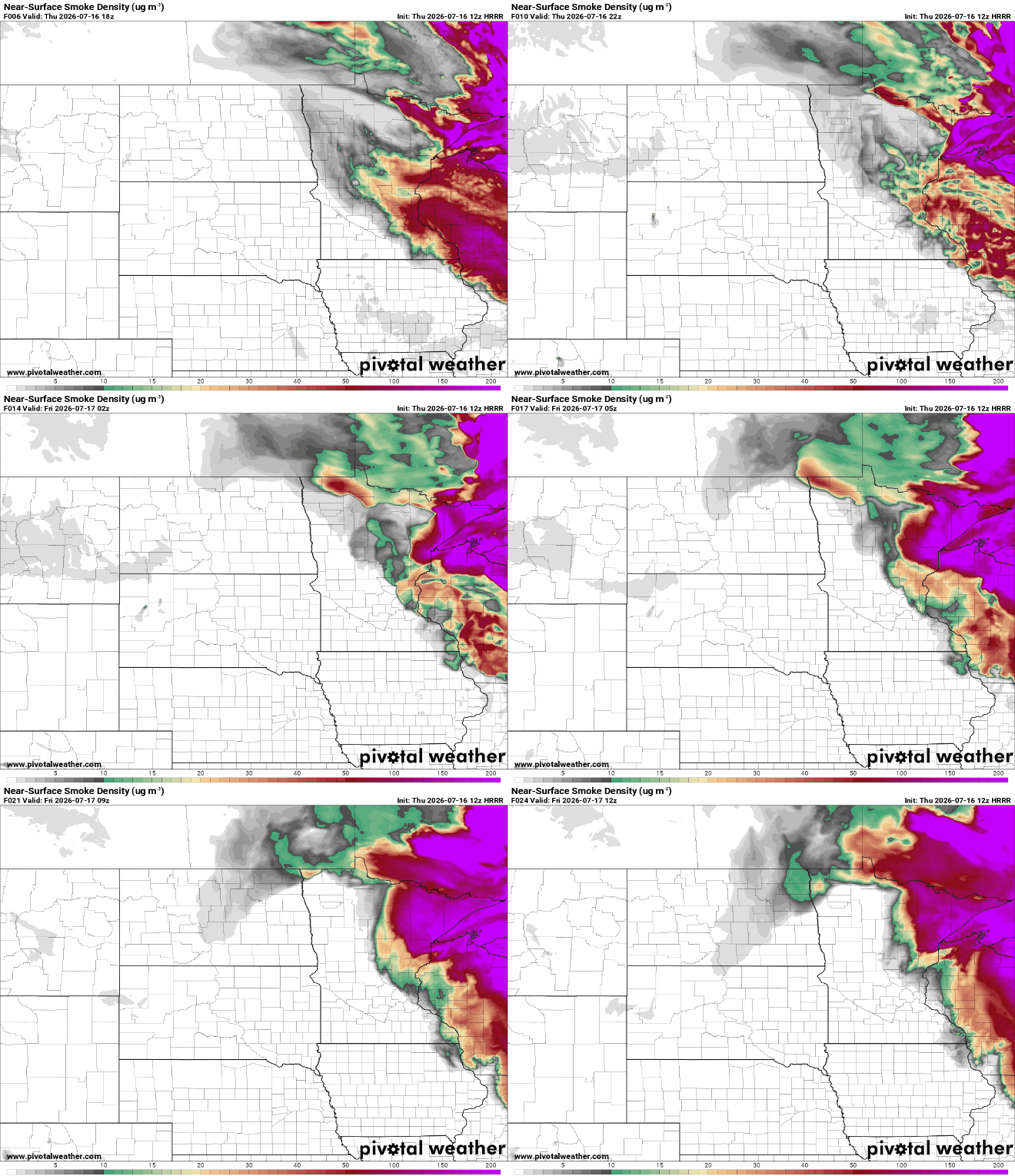
Until then continue to limit time outdoors, avoid strenuous activity and keep an eye on updated air quality forecasts.
This has been an exceptional smoke event, with some of the highest particulate readings ever observed in parts of Minnesota.

