
Cooler week ahead. Another wall of rain by Friday
Temperatures are bringing a brief taste of early autumn for now

Go Deeper.
Create an account or log in to save stories.
Like this?
Thanks for liking this story! We have added it to a list of your favorite stories.


Almost every Minnesotan got — or will get — rain on Monday. We have another slate of cool mornings and then another solid wave of rain by Friday. Some fall colors should begin to pop up in Northern Minnesota soon, as well.
Monday’s sleepy rain
Is there such a thing as perfect napping weather? We think so, and it looks a lot like Monday. Overcast skies, a gentle rain, a very limited severe weather threat, cooler temperatures — plus it’s coming after a lovely weekend. The rains will be off and on through the rest of Monday afternoon into the early evening. That said, most will not go to bed with rain hitting the roof Monday night; the primary baroclinic wave pushes out late Monday evening.
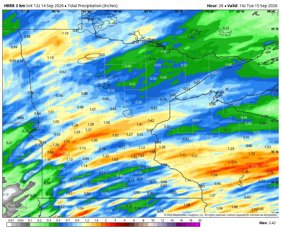
So far, we haven’t seen enough rain to make this above map too accurate, but there is hope for a drought-helper through the end of Monday. There is also a brief southern streamer of rain for far southern Minnesota early Tuesday morning. If you are out and about on the roads of northern Minnesota, anywhere on the North Shore and the Iron Range, we are expecting dense fog later Monday night. The weather computers bust the fog out of here by midmorning, but we shall see on how fast the fog gets out of Minnesota.
Turn Up Your Support
MPR News helps you turn down the noise and build shared understanding. Turn up your support for this public resource and keep trusted journalism accessible to all.


Tuesday is also going to be quite a cool day, even with drier conditions. Behind the cold front, temperatures are well below average. Only a few Minnesotans will be lucky enough to reach 70 degrees. Even though we are dry, the clouds are going to hang steady, primarily in southeastern Minnesota along with the northern half of the state. The upper low has so much cold air coupled with it a couple of miles up, it will produce off-and-on clouds, so just be ready!
Wednesday should have a few showers, though the exact placement of the weak boundary is going back and forth on our computers. If we put our bets down now, we’d say the light rain is pretty far north and mostly late Wednesday night. It only appears to be isolated now.
Late week rain chances
Clouds steamroll in on Thursday afternoon ahead of a steady rain starting early Friday. This should also (like Monday) be a solid rainmakers for most of Minnesota, lasting throughout the day Friday and into at least Saturday morning. Some weather maps scour the clouds out quickly on Saturday, leaving us with a milder day.
From there, a big high-pressure corridor builds across the entire Upper Midwest. That should leave us with bluebird skies from Sunday through possibly next Wednesday. That being said, we could be a little colder in the mornings as a result of the clear skies.
Colder mornings plus shorter days (OK, the daylight is shorter, not the actual day) means that leaves will begin to turn this week in northwestern Minnesota. The high resolution and true-color satellites do not show much fall color yet, but the state’s Department of Natural Resources fall color map does show that changes are likely in rural northwestern Minnesota later this week. That’s pretty normal timing for the first pops of color. The DNR has the peak of fall colors around the Twin Cities slated for Oct. 19 as of now.

