
Drought gets big help in western Minnesota
Several rounds of rain should partially knock out drought, primarily in the NW part of the state
Go Deeper.
Create an account or log in to save stories.
Like this?
Thanks for liking this story! We have added it to a list of your favorite stories.


After the sunshine finally burst through the cloud deck and marine layer fog, we had closer-to-average temperatures. A brilliant sunset should be looming, with some mid-level clouds adding a pop of color.
Have you been hearing about the storm off the Atlantic Coast? I would venture to guess yes, because the storm has been everywhere on national news. For us, there is sinking air on the back of this storm. That’s making an “accordion” with weather in this part of the U.S., compressing storms over our region.
That impact will be most pronounced on Saturday. It will be very much a repeat of late Wednesday into Thursday. In simple terms, we’ll have lots of clouds, heavier rain in western Minnesota, and just a few paltry rain amounts around southeast Minnesota and the I-35 corridor.

There are a couple of subtle differences, like even heavier rain in Iowa. If you enjoyed Thursday around the Twin Cities, you’re in luck! Saturday is pretty identical. Plus this will help the drought in other parts of the state.
Turn Up Your Support
MPR News helps you turn down the noise and build shared understanding. Turn up your support for this public resource and keep trusted journalism accessible to all.
We have heard from many of you who want sunny and warm weather for one of the final “mild” weekends of the year (at least historically it’s one of the final mild weekends, El Niño could change things a bit).
If you’re wanting more sunshine, however, Sunday into Monday is probably more your speed. Both days should be in the lower 70s for southern Minnesota — including the Twin Cities — and middle 60s farther north into the North Star State.
The main event next week
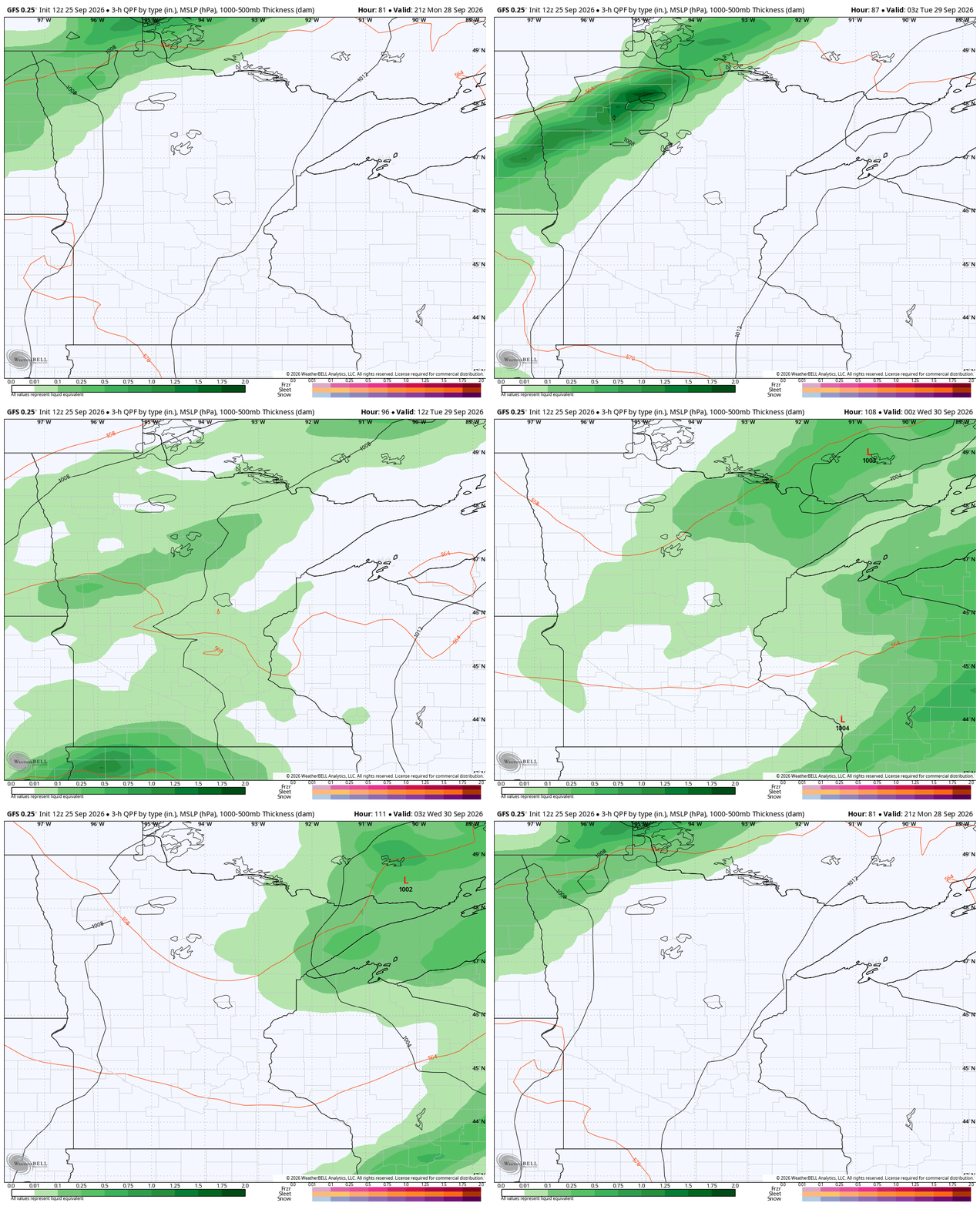
After just two days of largely-sunny skies, the clouds are heralding more rain. This actually starts in northwestern Minnesota later Monday afternoon. For most of the state, however, the rain gets here early on Tuesday. We are still looking for over an inch of rain in many locations.
We could also get a Great Plains low skirting our Iowa-Minnesota border later next week on Thursday. That would serve up some more healthy rains along the Minnesota and Iowa border. Though much of this region is no longer in drought, it would not hurt to bank more rains ahead of 2027.
Apart from that potential complex (and often these end up diving just south of Minnesota altogether) the rest of the work week is pretty quiet as active weather goes. We will talk more about this system in Saturday’s Updraft!

Beginning next Friday, most longer range tools do start shaving a few degrees off of the lows and highs each successive day. By the week after next, several bar charts have highs in the Twin Cities down into the 50s. As you might imagine, accuracy falls off a ton after a week. So this is all pretty subjective, but there are signs of a cooldown looming.

What comes after, El Niño impact or not? Those cold signals the week after next probably won’t last too long. After that, the seasonal tools pop in warmer weather. Above is a blended map of the Lower 48 states, showing us with warmer temperatures.
This is all averaged out from now through the first bit of November, a pretty clear warm signal.

