
I just saw Halley's Comet + nearing record warmth
We have near-record highs and record-warm lows coming this week ahead of some frigid rains
Go Deeper.
Create an account or log in to save stories.
Like this?
Thanks for liking this story! We have added it to a list of your favorite stories.


Enjoy the sunshine for the next several days. As a bonus, we have tons of warmth. You might miss both sides of the weather by next week when it’s drizzly and much colder!
BBQ alert time
We are already into the 70s on Wednesday afternoon. The normal highs have fallen off very fast as of late. The normal for Minneapolis on Oct. 21 is actually only 55 degrees. As I type this from downtown St. Paul, we are 71 degrees and sunny. About three-quarters of Minnesota will top out in the 70s for the rest of Wednesday.
Orionids peaking
Please tell me you caught the Shinedown reference to kick off this Updraft? Anyone?
Wednesday night is the peak of the Orionid meteor shower, when Earth travels through a plume of dust leftover from Halley’s Comet. Basically, you’re going to want to look at Orion late Wednesday night, away from city lights. The big (Halley) show is not until 2061! Here is what NASA says:
Turn Up Your Support
MPR News helps you turn down the noise and build shared understanding. Turn up your support for this public resource and keep trusted journalism accessible to all.
“The Orionid meteor shower peaks on Oct. 21, and viewers may see about 3-6 meteors per hour in suburban areas with some ambient light, while those in darker areas may see a few more. These meteors come from debris shed long ago by Halley’s Comet, igniting in our atmosphere as Earth passes through the comet’s trail. The shower is named after its radiant, near the constellation Orion, the hunter. Orion also contains the red supergiant star Betelgeuse, whose scarlet glow is easy to spot in the autumn sky (but don’t say that name three times in a row!).

This year, the moon will be in a waxing gibbous phase, which may wash out some of the fainter streaks. But once it sets around 3 a.m. local time and the radiant climbs higher in the sky, a prime viewing window opens, giving sky watchers an excellent chance to catch the show before dawn.”
Back to warmth, then cold rain
Thursday is really quiet, effectively a carbon copy of Wednesday. Readings might be about a degree or so warmer but that’s about the only change.


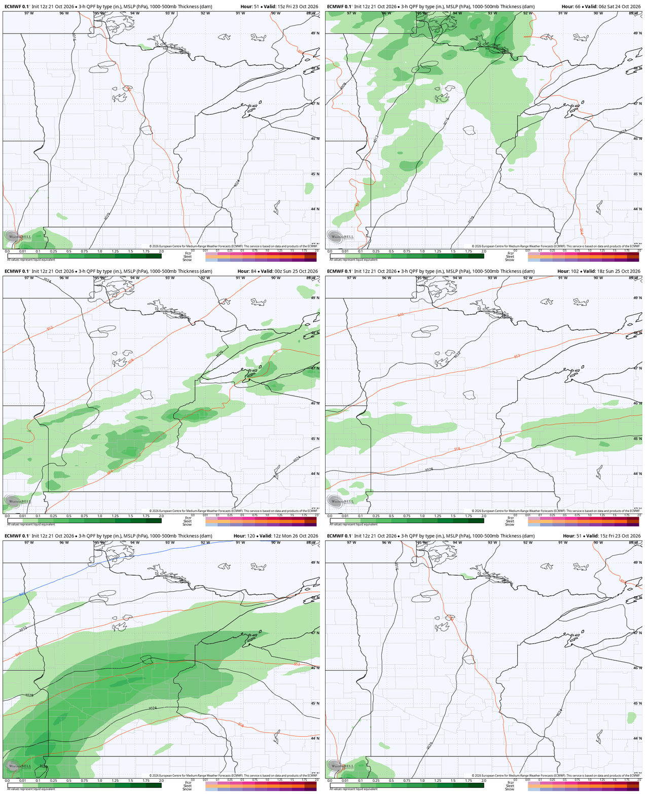
Friday does bring a few showers, seen in the first image of this Updraft. Rain starts in the Upper Minnesota River Valley Friday afternoon, before moving northeast while spreading out a little more. Saturday is not as rainy looking, with isolated light showers northeast and southwest in Minnesota. Rain is more likely Saturday night. A secondary low tracks in from Nebraska on Monday into Tuesday.
Not only does that set up a possible fourth and fifth day in a row for some Minnesota rains, but it also enhances the cold air streaming in from Canada. Highs between next Tuesday through Thursday could easily not make it to 50 degrees. We could also be close to freezing with a few snowflakes north.
Spooky season, mild weather

Yes, we are rolling the clock forward as you make some later decisions on costumes. We want to give you as much heads up as possible, friends! Halloween briefly trended colder based off of Tuesday’s data. Now things are more moderate. We’d have Twin Cities temperatures beginning in the upper 30s, topping out in the middle to upper 50s. Technically that’s actually above average. With all the sugar in your system, you’ll be bouncing off the walks and breaking a sweat!

