
Thunder and warmth, then a mild trick-or-treat
Snow to thunderstorms and all within 36 hours of each other. Plus we're looking ahead at the Halloween forecast
Go Deeper.
Create an account or log in to save stories.
Like this?
Thanks for liking this story! We have added it to a list of your favorite stories.


From thunderstorms to Halloween trick-or-treating weather, we’ve got a lot to talk about.
Snow no more, warmth returns
As expected, the snow flying was merely a novelty for winter lovers. You’d really have to be a night owl, or a third-shift worker, to see much fly. A hint of snow stuck in parts of North Dakota and South Dakota, but we have not witnessed any reports of snow sticking in the North Star State.
Rain is pulling out of Minnesota by early Tuesday afternoon, with the Mississippi and St. Croix Rivers being the final stop. Fog is definitely an issue (and always will be in this muggy autumn weather setup, which traps moisture over and over) in central and northern Minnesota.
Tuesday night should be a little milder and a lot drier. That said, a few isolated rain showers are possible along the Interstate 90 corridor in southern Minnesota. There is a pretty steep difference in temperatures overnight; from the mid-30s north, 40s on the North Shore, mid-40s through much of Minnesota, and a warm nose of temperatures in far southeastern Minnesota.
Turn Up Your Support
MPR News helps you turn down the noise and build shared understanding. Turn up your support for this public resource and keep trusted journalism accessible to all.

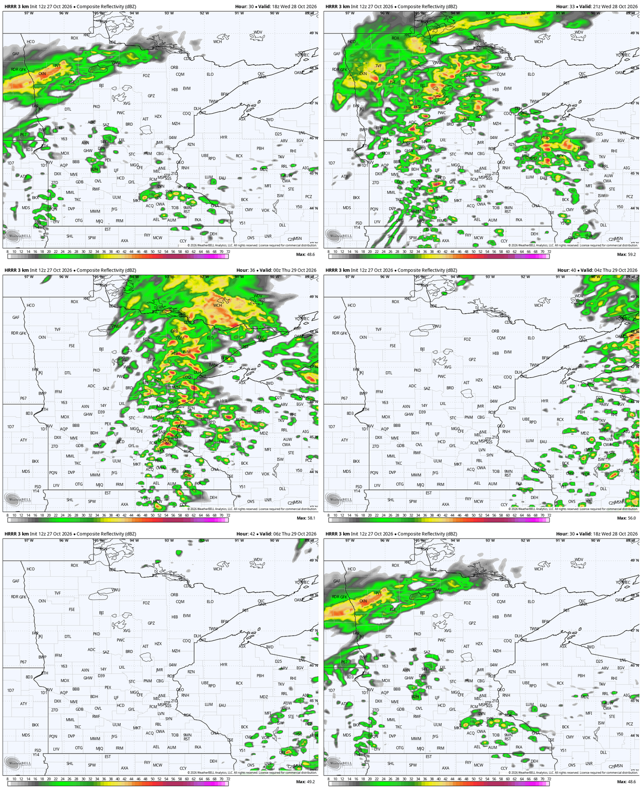
Thunderstorms kick off in the early afternoon Wednesday for western Minnesota, spreading east and developing further through dinnertime Wednesday. While the below image of high temperatures seems pretty mild, we think this will be very brief. There’s a quick surge of moisture north that corresponds with a fast warm-up, but this will only last a couple of hours.

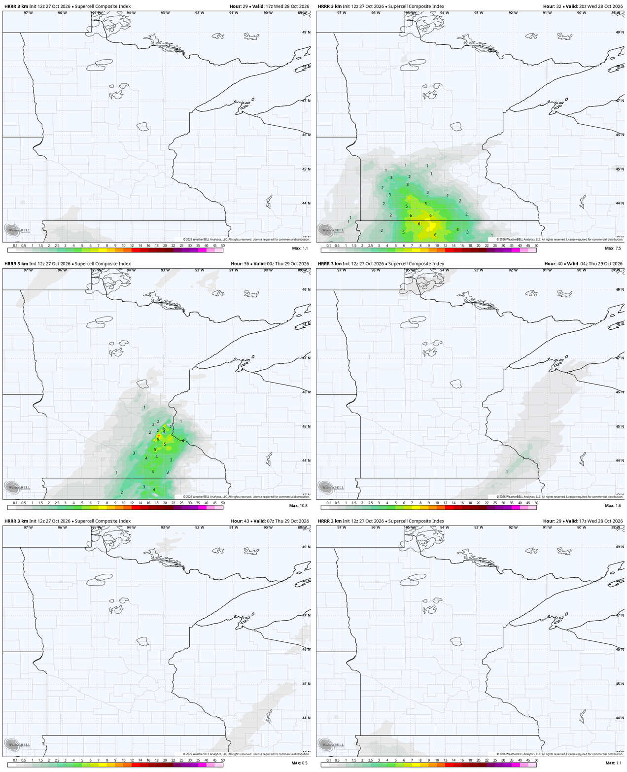
While widespread severe storms do not appear likely at all on Wednesday, a few could be strong. The graphic below highlights this rush from the northwestern Iowa corn belt and lake resorts, up towards St. Peter, Mankato and Rochester. Lightning is more likely than anything else, so just be mindful for any outdoor plans later Wednesday.
The Little Dipper
In the lower lefthand corner of my work computer, the automated weather blurb has been yelling at me about temperatures falling later this week! Yes, even meteorologists have that Windows weather alert that comes stock on many modern machines. Sure, it will get cooler, but we’ll still end up well above average. There will also likely be a few novelty snowflakes flying around Thursday night into Friday morning. This goes from Roseau to the International Falls area, then onto Voyageurs and the Boundary Waters.

Lingering warmth past Halloween
The big question for me is what any rain could look like on Halloween. New modeling from the Europeans has us mostly dry on Saturday, which is a change. The Canadian mapping has a little afternoon rain near the Twin Cities, while an American map called the GFS is really rainy through the afternoon. The inconsistency is obviously not our favorite! We like to see a real trend and, honestly, there is no reliable trend on Halloween precipitation at the moment.
We do think the windshield wiper back and forth for Halloween will resolve itself soon, however. What we can say is that Halloween is likely to be a fairly mild day of temperatures. Upper 50s may not sound very warm, but they’re nearly 10 degrees above normal. Plus, I’m sure you’ve heard about a certain Blizzard in 1991 around here… so it can be much colder and active.

By Monday next week, it’s the Weatherman’s Woe: Beware the Cutoff Low. A jumbo U.S. storm comes out of the Rockies and just pelts us with rain chances through much of the next workweek. While we do have lots of time to fine-tune the forecast, Election Day looks like it could be really soggy with rain.

