Minnesota weather: Records for everyone to share
Go Deeper.
Create an account or log in to save stories.
Like this?
Thanks for liking this story! We have added it to a list of your favorite stories.


How about records for the warmest overnight temperatures in parts of Minnesota? Records for the latest measurable snows in places? Or records for daily high temperatures? All of this warm weather lasts just a few days longer, before a larger drop in temps. We are on the rebound in time for Thanksgiving travel and then looking at a possibly-busy start to December.
Unbelievable November stretch rolls on
You might be tempted to think that this warmth through November is normal at this point. I certainly have that thought; after all, we have only had a few hard freezes. Outside of those, it’s been incredibly warm all across the state! Certainly this is not the norm, and part of it is likely a function of the powerful El Niño. Minnesota has seen abundant warming in the cool seasons.
The mix of clearer skies and clouds continues through southern Minnesota on Thursday. For northern Minnesota, starting this Wednesday evening, there may be a very uneventful sprinkle near Warroad, Roseau, and Thief River Falls. These continue through the morning of Thursday, but are nothing to broadly change plans over.

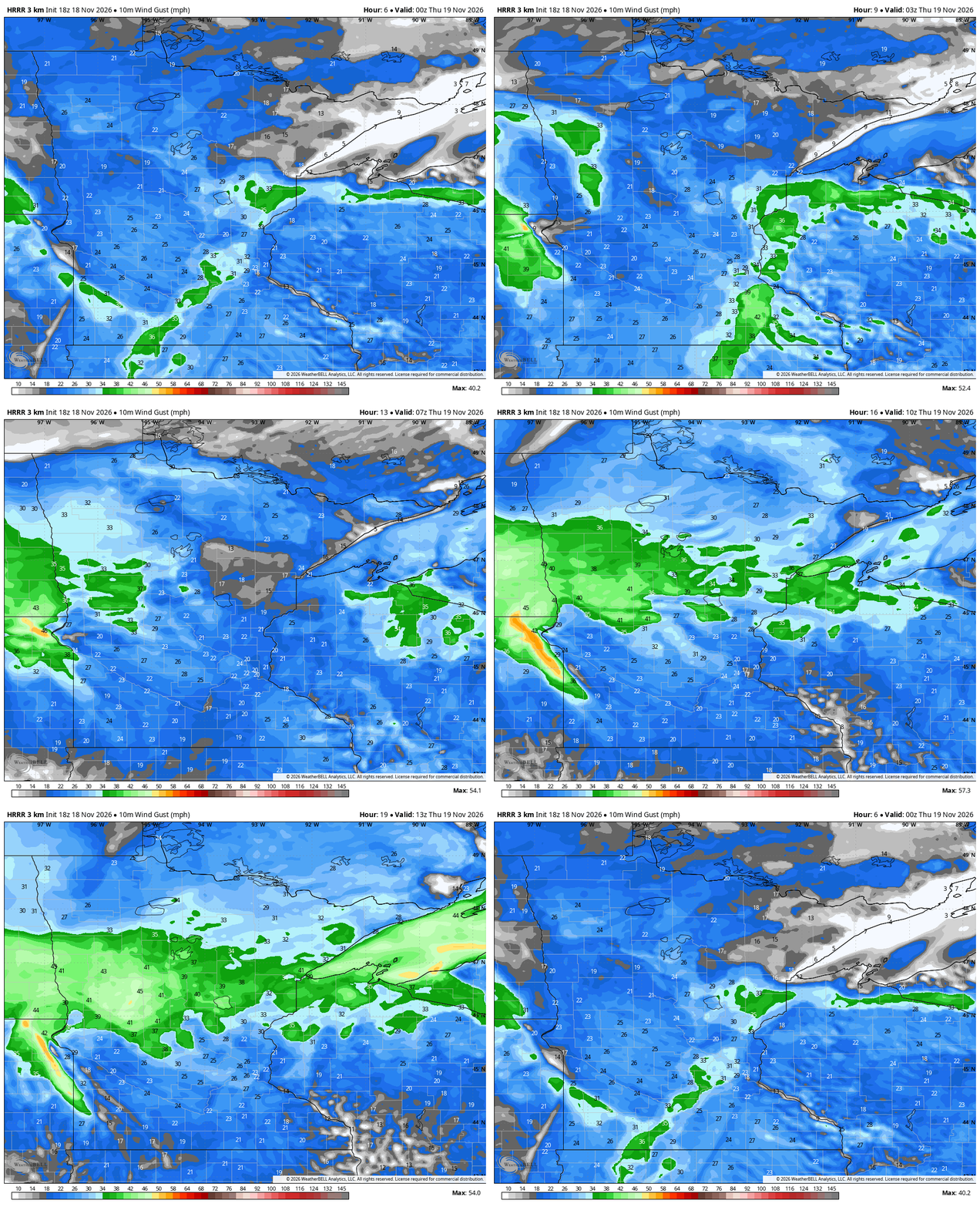
The winds will really ramp up later Wednesday night into Thursday. Buffalo Ridge in Pipestone, Rock, and Murray Counties will probably be howling overnight - with gusts easily over 40 mph expected. There is also a Gale Warning posted for most of Lake Superior from the same general storm complex, though this is mostly something for the big lake’s mariners to contend with heading into Thursday (and they are very highly attuned to the weather).
Turn Up Your Support
MPR News helps you turn down the noise and build shared understanding. Turn up your support for this public resource and keep trusted journalism accessible to all.
Once again, high temperatures will be well above the normals heading into Thursday. We’re forecasting some 40s north, middle 50s in the Interstate 94 corridor (including the Cities) and some isolated 60s farther to the south, in places like Winona, La Crosse, and Decorah.

For Friday, there are limited showers in northwestern Minnesota - those stay as all rain and we’re still quite warm. For southern Minnesota on Friday, we are still all dry, though I would expect some more off-and-on cloud cover. We could easily burst into the 60s through much of the daytime Friday afternoon. Not only is this a full two weeks after our typical last 60 degree high of the year, but it could also break a bunch of record highs across the Upper Midwest region.
Weekend storm update
The Friday-Sunday storm just keeps growing larger and larger across the USA and Canada. What does that mean for us? Well, surprisingly, it could actually mean that more of Minnesota stays drier on Saturday, because of a bigger ‘dry slot.’ That is a dry segment of a larger storm that snuffs out rain (or whatever the precip time happens to be; this is also something we’ll see happen with winter snow storms).

The winds on Saturday will begin to shift from the south to the west-northwest around noon. That will kick up a raw feel, and any rain that falls could come down sideways - and with a cold bite. While Saturday will technically be a warm day once the record books are finished, most should find it to be colder and windy. Plus there is some rain, concentrated in the northwest along with the Interstate 35 corridor. We are still expecting rain from Rochester to the Cities, clipping Duluth, as well.
Much colder Thanksgiving week
What goes up must come down and all that, right? Well, we’ve known that Sunday through next Tuesday would end up pretty cold. After all, we’re pulling down a tremendous amount of crisper Canadian air all the way into Minnesota for a few straight days. It’d be like us opening up the castle drawbridge and then just leaving it open for cold air to flow in for days. We’ll keep working on the analogy!
The newest data from the longer range maps (Global Forecast System, European Center for Medium-Range Weather Forecasting, the Canadian mappers) all has Wednesday and Thursday being much colder than it previously appeared! For now, models are suggesting high temperatures all the way down to the Twin Cities in the upper 30s for much of next week, now including Thanksgiving Day itself.