More records, El Niño spiking, and a big drop-off
From record warmth to coat weather within just a few days!

Go Deeper.
Create an account or log in to save stories.
Like this?
Thanks for liking this story! We have added it to a list of your favorite stories.


We have a new winter outlook for 2026-2027 based largely off of El Niño. We also have more records for warmth Friday afternoon and again on Saturday morning. Then a powerful front drops our temperatures off a cliff’s edge.
While it’s still a little early on, we’re also seeing a hint of snow next week and a much colder Thanksgiving forecast.
El Niño update!
We often have a much warmer wrap to winter under a powerful El Niño regime, and it can be tough on snow conditions as well. Our incredibly mild end to October and start of November might be a little puzzling; in the past, we had seen cold spells around these times.
For this winter, however, it’s looking fairly grim for snow lovers. However, one rogue storm track could completely shift a winter’s fortunes. Plus, El Niño is only a starting point to help guide us meteorologists.
Turn Up Your Support
MPR News helps you turn down the noise and build shared understanding. Turn up your support for this public resource and keep trusted journalism accessible to all.
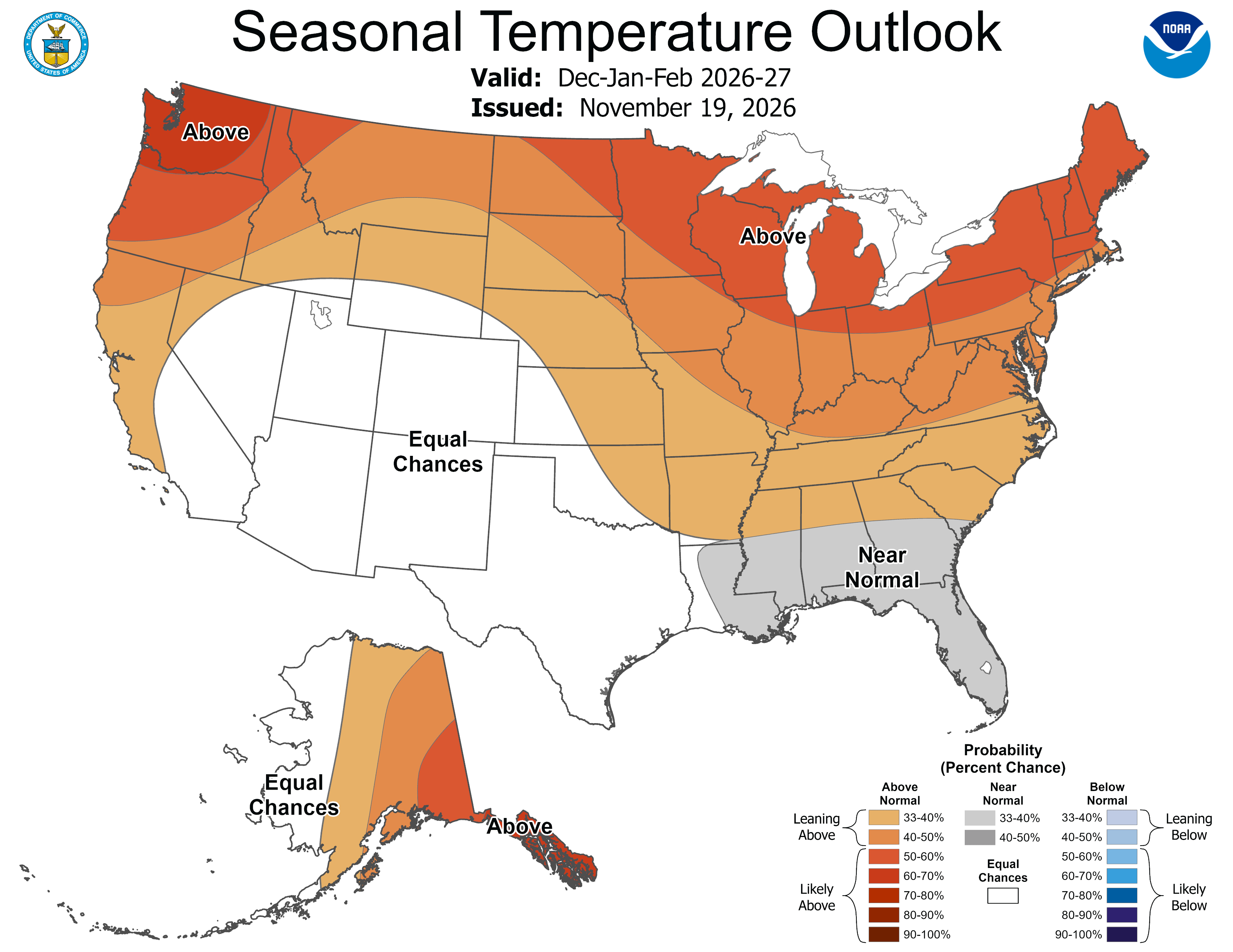
When it comes to temperatures, we’re likely to have an above-average winter. That comes on top of an already-warming winter, which is Minnesota’s fastest-warming season under climate change.
“Above-normal temperature probabilities exceed 50 percent for much of the Northeast, Great Lakes, Upper Mississippi Valley, Pacific Northwest, and southeastern Alaska,” according to the Climate Prediction Center.
What’s uncertain is how impactful a weak Arctic Oscillation will compete with El Niño.
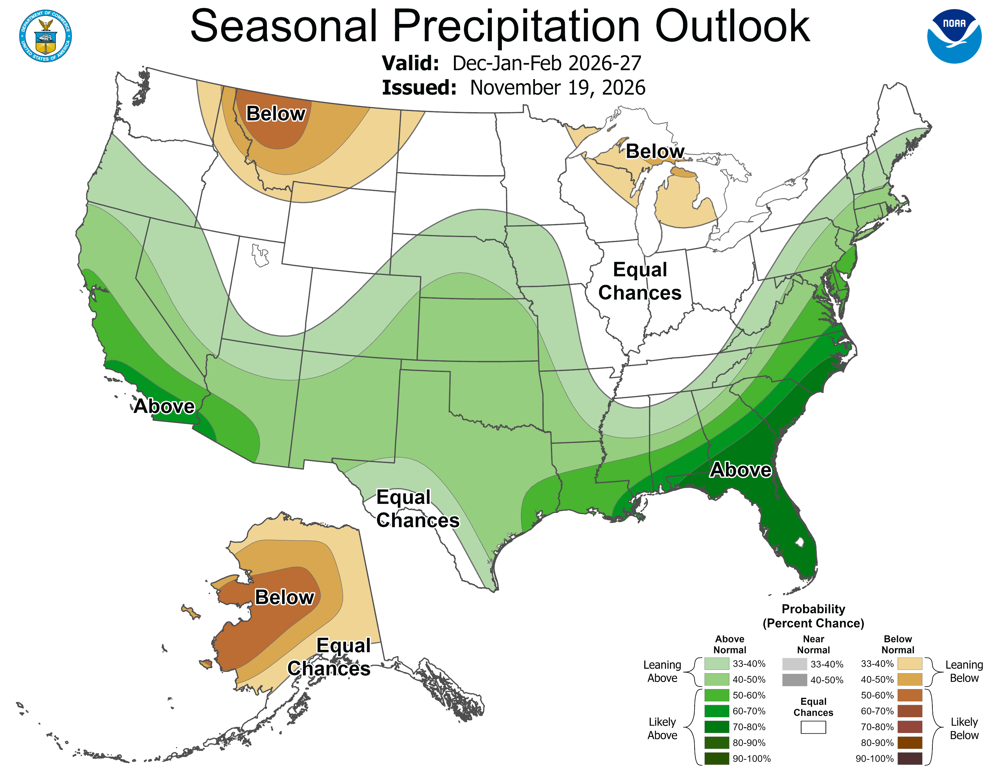
As far as precipitation, Minnesota and our nearby neighbors are one of the only zones that stay reliably drier in a super El Niño setup.
From the CPC: “Consistent with the El Nino response and its southward shift in the storm track, elevated below-normal precipitation probabilities are forecast for parts of the Great
Lakes and Northern Great Plains.”
A higher potential, but for less rain and snow. That’s the forecast!
Back to the records
We just crushed a bunch of records on Wednesday, from Hibbing to Duluth to International Falls. Additional notches in the 2026 record books could come Friday afternoon, with high temperatures across the state, nearly 20 degrees above average for the last third of November.
Saturday morning could spell more records breaking for the warmest overnight temperatures. These are actually becoming more commonplace in our warming climate, which often sees much warmer overnight temperatures as a signal.

A few rain showers will start to develop Friday morning in the far northwest, near Lake of the Woods and the Northwest Angle. They’ll steadily move southwards toward Red Lake and then on towards Brainerd and Bemidji.
We don’t expect much rain for southern Minnesota on Friday, but it will still be warm all over! There could be a passing sprinkle around dawn Friday.

Saturday is the better statewide chance of rain. But the best chances are actually in far southeastern Minnesota, over to Decorah and La Crosse. Up to half-an-inch could drop.
A ton of Minnesota stays dry Saturday. Still, the winds will whip up Saturday afternoon and help drop temperatures.
Thanksgiving week (turkey) swan dive
OK, we know turkeys can fly, at least a little bit! But this turkey is plummeting downwards for Thanksgiving Week, along with the low and high temperatures. Sunday into Monday will be proof of that huge dip. This is common for late November — these numbers early next week are closer to our average highs than we have been (on the warm side) lately.

There could still be a weak Alberta Clipper rolling in early next week, but for now, high pressure keeps most of Minnesota quiet. It will just be cold and sunny. Thanksgiving Day is likely to be in the 30s north and the 40s south. That’s totally normal!
Could we get some more active weather after the holiday? Well, maps sure ping the end of the month for some smaller snow chances. But as the data below showcases, the closer we’ve gotten to these ‘phantom events’ lately, they’ve started disappearing from our weather maps. That means we can’t trust our weather maps much past a week right now.
So, some maps do have snow starting around Small Business Saturday and Cyber Monday, but it’s not riding a particular trend.

Still, we are starting to risk records for the latest snows on record all across Minnesota. That will be something we watch as we get closer to Thanksgiving and December.