Drought deepens in Minnesota
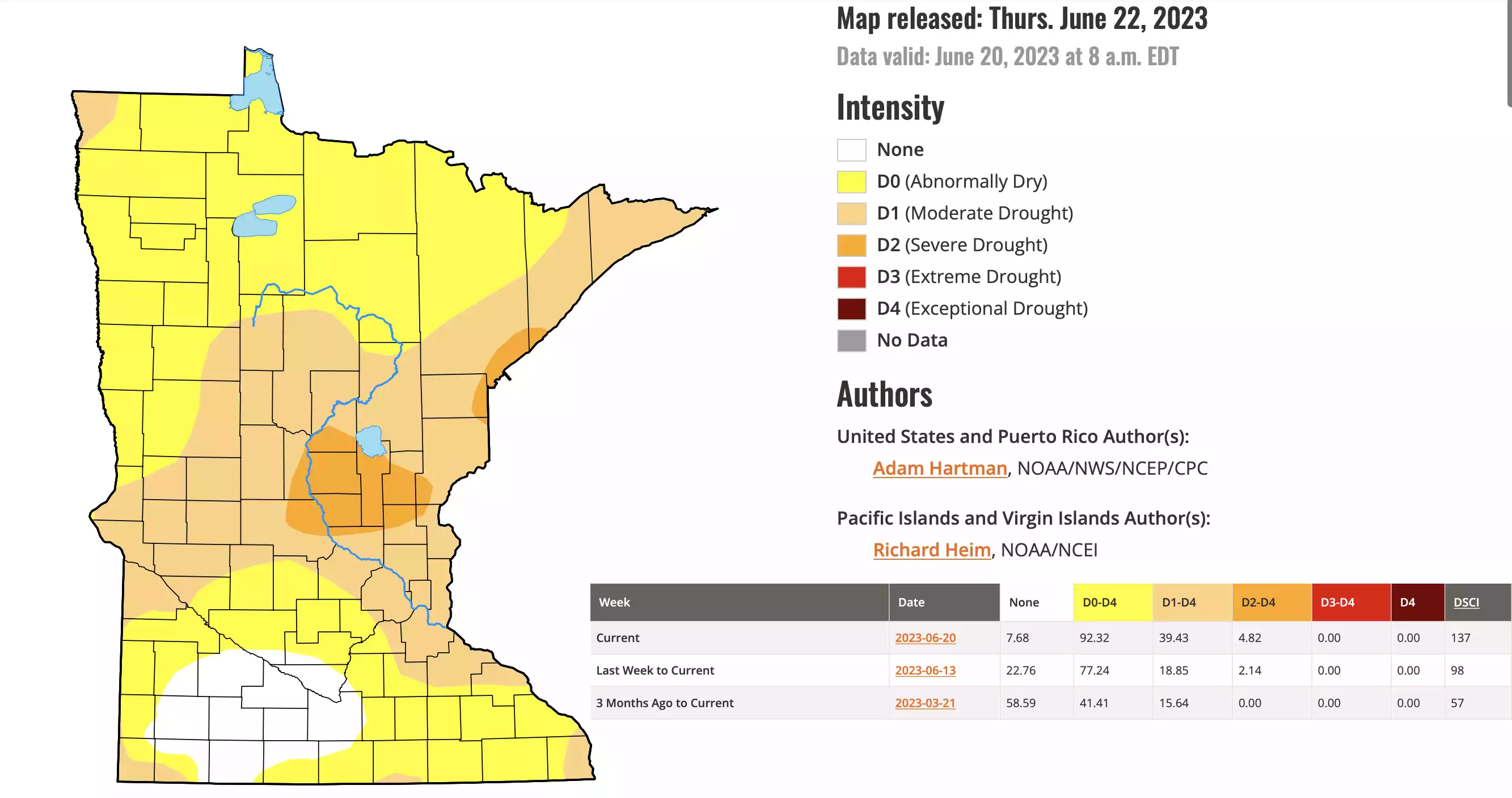
More than 90 percent of the state now is considered to be abnormally dry or in formal drought status.
National Drought Mitigation Center
Go Deeper.
Create an account or log in to save stories.
Like this?
Thanks for liking this story! We have added it to a list of your favorite stories.
Audio transcript
[MUSIC PLAYING] CATHY WURZER: Our top story deals with the weather. Here's a sound you probably haven't heard in a while.
[THUNDERSTORM]
Yeah, rain. Can you remember the last time you heard the sound of rain? For most of us in Minnesota, it's been quite a while. According to the latest Drought Monitor Report released this morning, drought conditions continue to expand across the state with more than 90% of Minnesota now considered to be abnormally dry or in formal drought status. Pete Boulay is the Assistant State Climatologist. He's on the line right now. Hey, Pete. Welcome back.
PETE BOULAY: Hi, Cathy.
CATHY WURZER: Today's report wasn't great. It shows a bigger chunk of Minnesota experiencing abnormally dry conditions. I guess that wasn't a big surprise to you. It's doubled since last week. Run down what you're seeing in that report.
PETE BOULAY: Yeah, pretty much, what happened over the past week is the area of moderate drought basically, doubled and also the area of severe drought, too. The moderate drought is mainly from the Twin Cities on north up the North Shore, a little bit in Northwest Minnesota. And the severe drought is in Central Minnesota just South of Mille Lacs and also around the Duluth area, too. So those are the areas that are seeing the biggest deficit in rainfall. About 4 to 6 inches short in the last 60 days.
CATHY WURZER: The Twin Cities hasn't had a lot of rain obviously recently, but some of the Southeast suburbs have had some pretty decent heavy rains. How complicated is it to assess the drought when there have been these locally heavy rains even though most areas are pretty darn dry?
PETE BOULAY: Absolutely. There's the haves and the have nots, and that's been kind of the pattern of the thunderstorms. I love the beginning with that sound of thunder you played, Cathy. I miss that sound. I haven't heard it in a while. And I'm in the North Metro and we've just been missing out. But the Southern Metro got some good storms in a few places.
You know what, Minnesota's a big state. There is actually places north of Robert Falls. I was there this weekend. That had water standing in the field. So some places got a lot of rain last week, but very spotty. More have nots than haves, unfortunately. So it gets to be tricky when trying to assess the drought because literally, your neighbor could have got more rain than you did.
CATHY WURZER: So let me ask you this because we saw this last year, too, kind of a flash drought situation. A, explain what that is. And B, are we heading into that?
PETE BOULAY: Well, we're definitely into a flash drought situation. And what's going on is two things is obviously, it's not raining. And also, it's been very, very warm. We've already had eight 90 degree days and today will be number 90 in the Twin Cities-- number nine 90 in the Twin Cities and that makes things worse.
I run an evaporation pan out here at our weather station on the Saint Paul campus of the University, and we lost 0.4, 4/10, of an inch of water for each day. In the last two days so nearly almost an inch in just a couple of days. So we're losing a lot of water off the landscape, too. So that's what makes the drought intensify even more. If you look back one year ago, today there was no real drought in the state. It was just a little bit abnormally dry conditions. So we're ahead of where we were last year for the drought.
CATHY WURZER: That's not good news. Is it tough to come out of a drought? I ask that because, I mean, once you have dry conditions, does doesn't it kind of almost kind of build on itself, in a sense?
PETE BOULAY: A little bit to the South, the drought is worse. Into Iowa, Missouri especially, they've been falling into drought quicker. So it can start to interfere, that moisture plume coming up from the South. But it's interesting. We're still living off our 90 inch snow season. The lakes around the Twin Cities had a great bump up in levels from over the winter. So we're falling in the lakes, but not quite as far behind as we were last fall. So we still have a little bit of water in the bank there.
But there's different stages. Your lawn would be very happy to get a half an inch of rain. I'm hoping for more than that. Because in order to keep up with-- keep pace with climatology, we should be getting about an inch of water a week in the Twin Cities. We're about 5 and 1/2 inches short of normal going back to May 1. So we wouldn't have to make up all that deficit. But in order to at least maintain, we'd like to see a return to normal rainfall.
CATHY WURZER: Is summer drought becoming the new norm because of climate change?
PETE BOULAY: Oh, good question. You know what, it's interesting that the 2010s was the wettest decade we've seen on record in the Twin Cities-- in the entire state of Minnesota. And then all of a sudden in 2020, it's like a complete shift. And now we're 2020, 2021, 2022, 2023. Fourth year in a row of dry conditions. I wouldn't necessarily pin this on a climate change signal. Drought's part of Minnesota's climate. We've had all kinds of droughts in the past. Some much worse than we're seeing now.
One year that comes to mind for how this year is starting is, like, 1976. It's very intense, very quick, and we fell behind fast. But the weather pattern looks a little optimistic for this weekend. I'll say that. The Weather Service is starting to talk about maybe we'll get 3/4 to an inch of rain on Saturday night. I hope that comes true, and I hope it's widespread.
CATHY WURZER: OK, that would be good to get that. But of course, we need more, right? So as you look into your crystal ball there, beyond this weekend, which as you say could be pretty positive, what's the long-term outlook from the Climate Prediction Center?
PETE BOULAY: Well, looking out over the next week or two, we have a little bit of a shift in the weather pattern. We have this high pressure over us and that looks like it'll finally move away. A cold front will come through this weekend. Knock back our temperatures. Hopefully give us a rain.
And then we remain rather unsettled. We have another shot of rain in the middle of next week with more of a West-East pattern coming. And, you know what, it does seem to be a tendency for still above normal temperatures so we'll probably stay above normal. I mean, obviously, this month, in June, we'll finish probably in the top 10 warmest in the Twin Cities because we're running about 5 degrees above normal already. So a return to normal temperatures, a high of about 80, might be a change of pace. I'll take it.
CATHY WURZER: And before you go, there's really no way to predict how long a drought will go on, right?
PETE BOULAY: It's very difficult. It's a changeable thing. It ebbs and flows. And this one could be a huge drought by the middle of July. My biggest concern is the crops. The corn crop needs the rain the most between July 15 and into August. Right now, driving around Southern Minnesota, the crops didn't look too bad. I saw some that were stressed a little bit, but they're not quite at the phenology where they need the rain the most. Middle of July is the key. So if we can turn this drought around by the middle of the summer, that'll do a lot. But you know what, this is the time of year we should be getting a lot of rainfall in the warm season. So we'll have to wait and see, and we'll just keep track of the weather.
CATHY WURZER: Oh, boy. All right, Pete Boulay, I appreciate your time as always. Thank you so much.
PETE BOULAY: Think rain.
CATHY WURZER: Yeah. We will, Pete. Thank you. You too.
PETE BOULAY: Thanks, Cathy.
CATHY WURZER: That's Minnesota Assistant State Climatologist Pete Boulay.
Download transcript (PDF)
Transcription services provided by 3Play Media.
