
Welcome rain soaks southeast Minnesota
Go Deeper.
Create an account or log in to save stories.
Like this?
Thanks for liking this story! We have added it to a list of your favorite stories.


[image]
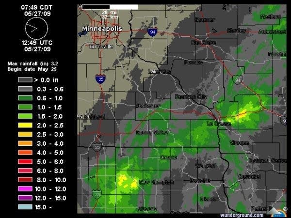
La Crosse radar storm total precipitation shows 1"+ rainfall for parts of Iowa, southeast Minnesota into Wisconsin.
So close, and yet so far.
A slow moving low pressure system in eastern Iowa this morning is bringing a good soaking rain south of the metro. Surface reports through 8 am confirm over an inch of rain at La Crosse (1.42") and around an inch at Rochester and Austin and Albert Lea. Doppler radar estimates over 2" in a band from north of Fort Dodge, Iowa to east of Mason City to a few miles east of La Crosse.
Turn Up Your Support
MPR News helps you turn down the noise and build shared understanding. Turn up your support for this public resource and keep trusted journalism accessible to all.
The rain comes as areas of the Upper Midwest are facing deepening drought conditions. Unfortunately for the metro, the southerly track of this system will keep the meaningful rains south of the area. Both the latest crop report and the U.S. Drought Monitor indicate the Twin Cities is at the epicenter of a growing drought.
Look for a cool, cloudy and breezy day today as the system exits the region. Sunshine and warmer temperatures will return tomorrow and last into the weekend. Temperatures will reach the upper 70's for the rest of the week.
It's great weather if you're a golfer or outdoor enthusiast. If you're a lawn, farm field or a tree, not so much. We need rain desperately in the Twin Cities.
The forecast models for the next two weeks keep the Upper Midwest in a northwest flow aloft. This is generally a dry flow for the region, with little in the way of widespread heavy rainfall. We'll be keeping an eye out for a pattern change to a southwest flow aloft which would bring deeper moisture from the Gulf of Mexico into the region. So far, it's not in sight.
PH

