
Severe storm threat today
Go Deeper.
Create an account or log in to save stories.
Like this?
Thanks for liking this story! We have added it to a list of your favorite stories.


[image]
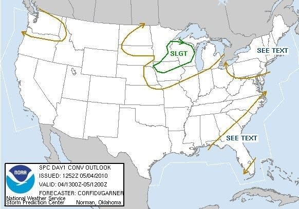
Storm Prediction Center (SPC) convective outlook today puts part of Minnesota in a slight risk for severe storms.
After the latest start to severe weather season on record, the risk for severe storms is on the increase today in southern Minnesota. Early morning thunderstorms have already gone severe south of Redwood Falls. There is the potential that storms may develop and move into eastern Minnesota later this morning.
The atmosphere is unstable enough to support a few severe storms through Thursday. The primary threat from these storms will be damaging winds and large hail, but an isolated tornado or two is possible. It appears the highest threat for severe storms is south of Minnesota into parts of Iowa and Nebraska today. Tornadoes were sighted yesterday in the Dakotas.
Turn Up Your Support
MPR News helps you turn down the noise and build shared understanding. Turn up your support for this public resource and keep trusted journalism accessible to all.
The pattern shift this week has brought much needed rainfall to the area. Twin Cities Airport picked up .66" of rain yesterday. Eden Prairie received .78" of nice slow soaking rain. Much drought stricken southern Minnesota saw between half and inch to over an inch of rain.
Here are some resources to track storms today.
Twin Cities radar storm total rainfall
Keep an eye to the sky later today!
PH

