
It’s flooding in Fargo-Moorhead again…
Go Deeper.
Create an account or log in to save stories.
Like this?
Thanks for liking this story! We have added it to a list of your favorite stories.


[image]
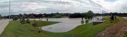
A spate of spring storms left the Red River Valley with swollen creeks and streams over the past week. Eventually, all that water must pour into the Red River and head north to Canada. The photo above was taken yesterday on the north end of the Island Park Levee in Fargo. Instead of a lake, you should see a parking lot and running trails in the foreground.
From approximately the same vantage point (and height of the river), the Red River looked like this back on March 24th:
[image]
The rapid rise in the river underscores the basic problem residents in the area will always have with flooding: the flat landscape. The [flood gauge](http://www.crh.noaa.gov/ahps2/hydrograph.php?wfo=fgf&gage=fgon8&view=1,1,1,1,1,1,1,1) in Hickson, just upstream from Fargo-Moorhead, illustrates this point. It takes a lot longer for water to flow out of the Valley than to accumulate in it.
[image]
Turn Up Your Support
MPR News helps you turn down the noise and build shared understanding. Turn up your support for this public resource and keep trusted journalism accessible to all.

