
Rain chances increasing tonight
Go Deeper.
Create an account or log in to save stories.
Like this?
Thanks for liking this story! We have added it to a list of your favorite stories.


[image]
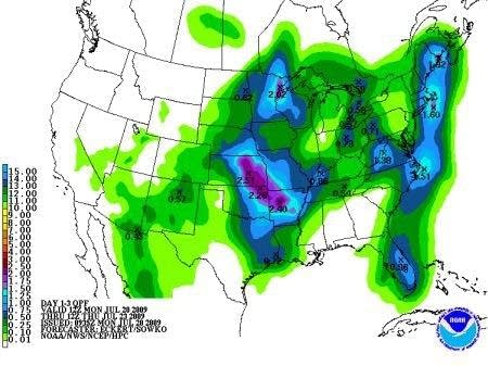
NOAA rainfall forecast hints at meaningful rain for parts of Minnesota.
We've seen this movie before. Let's hope this time the ending turns out differently.
Another summer cool front is bringing a chance of rain to much of drought stricken Minnesota and the Twin Cities. There are hopeful signs the rainfall will be heavy enough to be meaningful. There are also signs the rain could split into two areas and avoid the Twin Cities and much of east central Minnesota.
Turn Up Your Support
MPR News helps you turn down the noise and build shared understanding. Turn up your support for this public resource and keep trusted journalism accessible to all.
A band of showers and thunderstorms is moving through western Minnesota and the eastern Dakotas today. As the rain moves east it should spread into eastern Minnesota and Wisconsin overnight.
The forecast models are cranking out around .75" for the metro in the next 24 hours. That would be a nice soaker if we can get it. The line to the west looks pretty solid, but there are indications that a northern and southern flank could develop, and skirt the metro again. Let's hope not, much of central Minnesota desperately needs to get in on the rain this time.
There is a slight risk of severe weather with the storms today. Keep an eye out for potential warnings later today and tonight. Keep your fingers crossed for some good downpours too.
PH


