
Forecast: Scattered storms
Go Deeper.
Create an account or log in to save stories.
Like this?
Thanks for liking this story! We have added it to a list of your favorite stories.


[image]
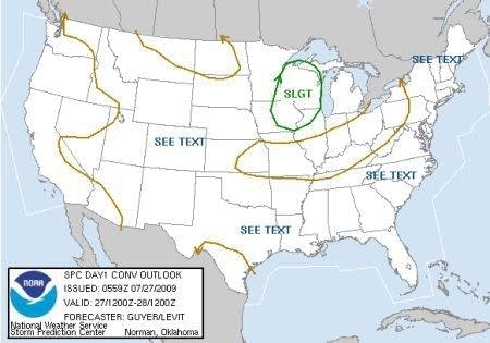
Storm Prediction Center indicates a slight risk for severe storms today.
Call it a watched weather pot.
Ingredients are coming together today around eastern Minnesota and Wisconsin for a few scattered severe thunderstorms. Here are some of the weather parameters that are lining up today.
Turn Up Your Support
MPR News helps you turn down the noise and build shared understanding. Turn up your support for this public resource and keep trusted journalism accessible to all.
-A cool front drapes from International Falls to near Sioux Falls this morning. The front will be near a Duluth to Twin Cities line by this afternoon.
-Moisture ahead of the front will support storms. Dew points are in the 60s ahead of the front.
-The heat of the day should push temperatures well into the 80s.
-A weak upper wave will slide over the area later today. This will help trigger storms.
Put it all together and you have an unstable atmosphere this afternoon. Storms that do form will move southeast today. Storms may contain hail and high winds. An isolated tornado can't be ruled out.
The good news is some of these storms will feature heavy downpours. Some areas could pick up some much needed rainfall. I'm hoping the weather lab garden is one of those areas.
Keep an eye to the west and northwest later today.
PH
Here are some tools to track storms today:
-Twin Cities NWS for watches and warnings

