
Forecast: Soaking rain?
Go Deeper.
Create an account or log in to save stories.
Like this?
Thanks for liking this story! We have added it to a list of your favorite stories.


[image]
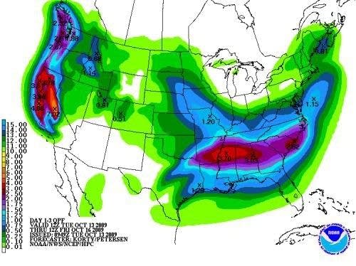
NOAA rainfall forecast indicates potential for a decent shot of rain by Thursday morning.
This might fall into the "I'll believe it when I see it" category. Or perhaps I'm from Missouri on this one. "Show me."
The most promising looking rain system in weeks appears headed for much of drought stricken southern Minnesota Wednesday night and Thursday. If the forecast models are right on this one, many areas could see a good soaking rainfall by lunchtime Thursday.
Turn Up Your Support
MPR News helps you turn down the noise and build shared understanding. Turn up your support for this public resource and keep trusted journalism accessible to all.
A slow moving wave will spin around our cool low pressure trough late Wednesday into Thursday. The system appears to have enough upper level support and moisture to spread rain into western Minnesota Wednesday afternoon and into the Twin Cities and eastern Minnesota by Wednesday night.
This system looks different from typical summertime convective systems. There may be a larger area of stratiform rain, which could produce a more widespread beneficial soaking rain for the southern half of Minnesota and much of Wisconsin.
If things go as the forecast models predict today, there could be widespread half inch to one inch rainfall amounts in southern Minnesota and western Wisconsin by noon Thursday.
There's an old saying in weather; "Don't forecast rain in a drought." There's another old saying, "it takes a flood to end a drought." Let's hope reality is somewhere in between this week.
PH


