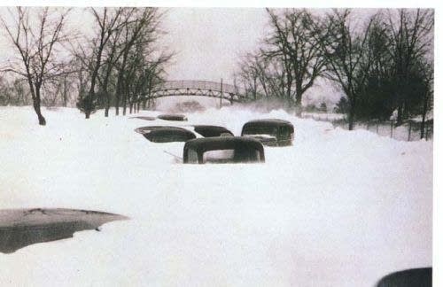
Armistice Day Blizzard: Could it happen today?

[image]

Abandoned cars buried on Excelsior Boulevard west of Minneapolis after the Armistice Day Blizzard. (Photo courtesy Minnesota Historical Society)

This is a bad weather week historically for Minnesota. Two of our fiercest and deadliest storms have occurred this week in November history. I blogged about The Edmund Fitzgerald Storm this morning which peaked on November 10th, 1975. The Armistice Day Storm of November 11, 1940 was one of the deadliest storms in Minnesota history.

The Armistice Day Storm is ranked #2 in the top 5 weather events of the 20th Century according to the Minnesota climate community. There are many unique aspects to the storm. One of the most commented on is the fact that the weather preceding the storm was unusually mild. Temperatures were in the 60s prior to the storm, luring duck hunters in shirt sleeves down to the Mississippi River that day.

Create a More Connected Minnesota

MPR News is your trusted resource for the news you need. With your support, MPR News brings accessible, courageous journalism and authentic conversation to everyone - free of paywalls and barriers. Your gift makes a difference.

Another facet of the storm was the rapid onset and temperature crash. Temperatures plunged 40 degrees on about 24 hours. About half of the 49 storm related deaths in Minnesota were duck hunters who drowned in or froze to death near the Mississippi River.

By the time the blizzard tapered off on the 12th, the Twin Cities had received 16.7 inches of snow, Collegeville 26.6 inches, and 20-foot drifts were reported near Willmar.

[image]

The powerful Armistice Day surface low winds up near Des Moines.

(Credit: NOAA)

The Armistice Day blizzard was not well forecast. In fact, the U.S. Weather Bureau office in Chicago that had forecast responsibility was unstaffed overnight during the storm. There were no updates on the storms increasing severity as it strengthened that night. That prompted local officials to pressure the Weather Bureau to add forecasters to the Twin Cities weather office. It was The Armistice Day Storm that was the likely catalyst to creating what is now the Twin Cities NWS office.

Another interesting part of the storm is what occurred over the Tacoma Narrows Bridge in Puget Sound as the storm passed. High winds caused the famous "Galloping Gertie" bridge collapse.

There is a good meteorological reason why some of our most intense storms occur in November. Temperature differences are among the greatest between Canada and the central U.S. in November. Single digit arctic air can pool to the north, and crash into relatively milder air that lingers in the 60s and 70s in the central U.S. Minnesota lies in the battle zone in between these two air masses.

The Armistice Day Storm would surely have been much better forecast today than in 1940. The Halloween Mega-Storm is a good example of a a forecast success story in modern times. Though eventual snow amounts were under forecast, the public was prepared for the storm well in advance. That saved lives during the biggest snowstorm in Twin Cities' history.

PH