
Rainy Friday arrives
Go Deeper.
Create an account or log in to save stories.
Like this?
Thanks for liking this story! We have added it to a list of your favorite stories.


An active warm front and low pressure center has finally pushed areas of rain into southern Minnesota. Some of the rain is locally heavy, with rainfall already in excess of 2" in some areas.
As the main body of the system finally moves through Friday, expcect areas of locally heavy rainfall.
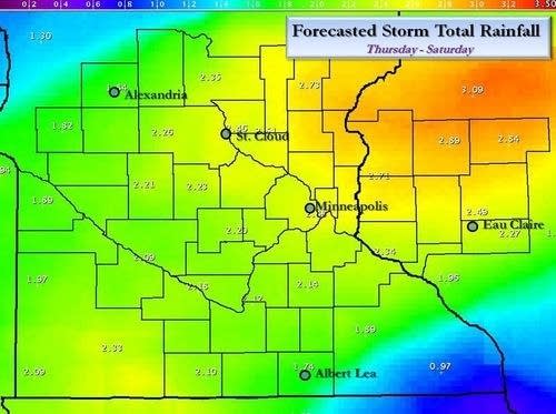
It's not often you see a swath of rainfall forecast at 2" over much of central and southern Minnesota. Check out the graphic from NWS below.
Turn Up Your Support
MPR News helps you turn down the noise and build shared understanding. Turn up your support for this public resource and keep trusted journalism accessible to all.
NWS forecasts for ranfall through Saturday
(click for bigger image)
As storms "train" or move over the same areas dumping heavy rainfall, it appears local areas will receive enough rain to meet or exceed flash flood guidance.
Here are some links to keep track of the rain.
-Twin Cities storm total rainfall loop
-Radar loop with lightning strikes
-NWS latest watches and warnings
PH

