
Thundery Thursday
Go Deeper.
Create an account or log in to save stories.
Like this?
Thanks for liking this story! We have added it to a list of your favorite stories.


August may rumble again for much of Minnesota through tonight into Friday.
Synopsis:
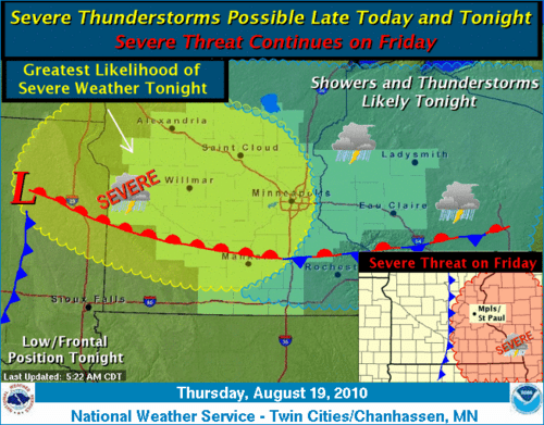
A warm front is draped from eastern South Dakota through southern Minnesota today. As a low pressure wave surges toward Minnesota later today, showers and T-Storms will increase near the front. Action may be going in much of southwest Minnesota today, and gradually spread east into the metro by late afternoon and tonight.
Turn Up Your Support
MPR News helps you turn down the noise and build shared understanding. Turn up your support for this public resource and keep trusted journalism accessible to all.
Severe Threat:
The atmosphere is unstable enough that some of the storms may reach severe potential later today and tonight. It appears the highest chances for severe weather will be in southwest Minnesota today, then transition toward the metro and eastern Minnesota this evening and overnight.
The primary threats will be large hail and damaging winds, but a few isolated tornadoes cannot be ruled out...especially in southwest Minnesota. It is possible that Minnesota will add to our already nation leading torando tally again today into Friday.
Heavy rainfall potential:
Some of the storms may dump locally heavy rainfall as they move slowly northeast. Forecast models are cranking out an average of about 1.25" of rainfall for southern into central Minnesota. Keep in mind that summertime convective rains are not usually evenly distributed, and amounts will vary greatly depending on location.
(click to enlarge image)
Bottom line:
Chances for storms will increase from west to east across southern Minnesota today and tonight. Keep an eye and ear out for possible warnings as the day (and night) wears on.
-Latest Twin Cities radar loop
PH

