
Major winter storm: 6″ to 12″ possible!
Go Deeper.
Create an account or log in to save stories.
Like this?
Thanks for liking this story! We have added it to a list of your favorite stories.


Here we go again!
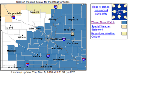
Winter storm watches have been posted for Friday night and Saturday as a major winter storm winds up and makes another run at Minnesota.
Here's my latest thinking on what looks like yet another Saturday snow event for Minnesota. I'll be looking at two more model runs (tonight & Friday AM) to look for any changes, but for now it looks like we are a "go" for heavy snow in the metro Friday night and Saturday.
Turn Up Your Support
MPR News helps you turn down the noise and build shared understanding. Turn up your support for this public resource and keep trusted journalism accessible to all.
-Snow begins sometime Friday evening, but really picks up intensity late Friday night after midnight.
-The peak of the storm should be Saturday...with the highest snow rates and increasing winds and blowing snow.
-At this point, I still think 6" to 12" by late Saturday is a good starting range for the metro accumulations...and much of central & southern Minnesota. This storm looks very similar to a week ago...which cranked out similar snow totals.
Two of our most reliable models are cranking out heavy snow totals. The latest NAM run says 14.1" The GFS cranks out 7.5"
Models cranking ot a wide range in snowfall totals.
It looks like another dry powdery type snowfall with high snow:water ratios. Both the NAM and GFS put the ratio between 15:1 & 20:1.
NAM snow water ratio at a powdery 15:1 to 20:1
NAM model paints a 14" snow "bull's eye" right over the metro.
Bitterly cold arctic air will pour in behind the storm. Temperatures may not climb above zero Sunday in the Twin Cities and southern Minnesota. Temperatures may reach -30 in the north by Monday morning, with -15 to -20 possible in and near the Twin Cities. Wind chills could reach the dangerous -25 to -35 range Saturday night & Sunday morning.
Bottom line: This looks like a major winter storm for the metro and most of central & southern Minnesota and Wisconsin...and could feature similar snow totals to last weekend...but with more wind and falling temperatures that could produce borderline blizzard conditions outside the metro Saturday.
Prepare for another shot of heavy snow, along with wind and bitter cold this weekend.
PH

