
Weekend: September preview; FL/Gulf hurricane potential next week?
Go Deeper.
Create an account or log in to save stories.
Like this?
Thanks for liking this story! We have added it to a list of your favorite stories.


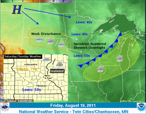
You may notice a slight hint of fall in the air this weekend. Don't fret, summer's not over and heat and humidity will return next week.
Call it "September lite." Friday's fresh northwest breeze sent dew points plummeting from near 70 into the 40s in Minnesota. The fresh transfusion of a Canadian air mass will be reinforced by Sunday, as a secondary front gushes south. Weak upper air disturbances will bring a few scattered (mostly light) showers or sprinkles this weekend.
Saturday: Mixed clouds & sun. Spotty showers. Highs in the 70s, lows in the 50s. Wind WNW 5-15 mph.
Turn Up Your Support
MPR News helps you turn down the noise and build shared understanding. Turn up your support for this public resource and keep trusted journalism accessible to all.
Sunday: Cool start with 40s north and low to mid 50s south! Highs in the 70s. Wind NW 10-20 diminishing later PM.
Hurricane Irene Next Week?
Wary eyes in Florida and the eastern Gulf Coast are on vigorous tropical wave 97L that could become Hurricane Irene next week.
"97L" has an impressive amount of spin in NOAA satellite loops, but does not yet have a well defined low level circulation. That may change in the next 24-48 hours as the wave becomes better organized at the surface.
Some forecast models (most notably the GFS & European model) have been consistent in developing the tropical wave into Tropical Storm Irene in the next 72 hours or so.
Wind intensity forecast for potential "Irene." 60 knots is the threshold for hurricane force. (74 mph)
The suite of forecast models is remarkably consistent and "tightly grouped" with Irene's potential track to near Florida or the eastern Gulf, and that has raised particular concern far in advance of any potential landfall.
(Click images to enlarge)
Stay tuned as we watch the potential for Irene as we head into next week!
PH

