
Wet start Tuesday; Tracking Saturday soaker
Go Deeper.
Create an account or log in to save stories.
Like this?
Thanks for liking this story! We have added it to a list of your favorite stories.


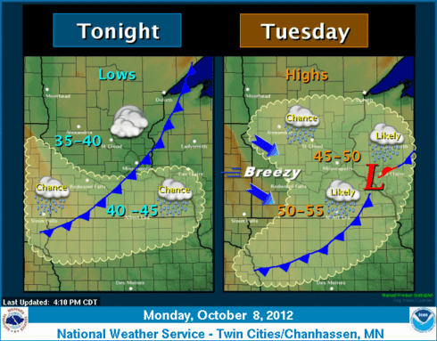
Upper wave brings showers early Tuesday
Wet AM drive in the metro Tuesday
.36" NAM Model precip output Tuesday
50s return cool week ahead
Turn Up Your Support
MPR News helps you turn down the noise and build shared understanding. Turn up your support for this public resource and keep trusted journalism accessible to all.
Saturday rain tracking 1st strong low pressure system in months this weekend
MAX/MIN TEMPERATURE AND PRECIPITATION TABLE FOR MINNESOTA
NATIONAL WEATHER SERVICE TWIN CITIES/CHANHASSEN MN
734 PM CDT MON OCT 8 2012
MAX MIN SNOW SNOW
LOCATION TEMP TEMP PCPN FALL DEPTH
DLH : DULUTH MN : 47 / 36 / 0.10/ 0.0/ 0
INL : INTERNATIONAL FALLS MN : 42 / 34 / 0.19/ 0.0/ 0
MSP : MINNEAPOLIS MN : 64 / 39 / T / 0.0/ 0
RST : ROCHESTER MN : 68 / 38 / T / 0.0/ 0
STC : ST CLOUD MN : 61 / 28 / T / 0.0/ 0
AXN : ALEXANDRIA MN : 59 / 39 / T
GNA : GRAND MARAIS MN : 48 / 35 / 0.18
HIB : HIBBING MN : 45 / 25 / 0.18
RWF : REDWOOD FALLS MN : 68 / 37 / T
Source: Twin Cities NWS
MSP Quick look forecast:
Two rain chances?
This is something new. Not one, but two potential shots of rain in the next few days?
Source: ISU
The NAM is printing out temps mariginally cold enough for at least a chance of snow early Tuesday morning. Some wet snow flakes can't be ruled out.
Saturday's system looks impressive, and has at least the chance to produce a widespread, meaningful, soaking rain for much of Minnesota.
Source" NOAA GFS via College of DuPage
PH

