

Severe hurricanes become more common as the climate changes
Go Deeper.
Create an account or log in to save stories.
Like this?
Thanks for liking this story! We have added it to a list of your favorite stories.

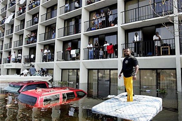
Six months after Hurricane Sandy, the areas hit by the storm are still recovering and hundreds remain homeless. Kerry Emmanuel, professor of atmospheric science at MIT, joined Kerri Miller to discuss how these types of severe hurricanes are becoming more common as the climate changes. Here is an edited transcript of their conversation:
Kerri Miller: You were one of the guests at Yale's Climate and Energy Institute Conference last week, and the focus was on water and the changing climate. Is the change to water patterns one of these things that's overlooked when we look at the consequences of the changing climate?
Kerry Emmanuel: It is indeed. When we talk about global warming, the term itself denotes changes in temperature, and that indeed does happen, but that is probably not the most serious consequence of climate change. One very robust prediction that you don't need supercomputer models to do — just a few lines of physics on a piece of paper is enough to tell you that hydrological extremes get more extreme as the temperature of the planet goes up. Although the annual global average rainfall doesn't change very much, the rain that does happen gets concentrated in fewer but more intense rainstorms. Ironically, you get more floods and more drought when you get global warming.
Miller: Break that down. We're talking about frequency and intensity? Or not frequency but increased intensity?
Turn Up Your Support
MPR News helps you turn down the noise and build shared understanding. Turn up your support for this public resource and keep trusted journalism accessible to all.
Emmanuel: We're really talking about a reduction in the frequency of rainstorms but an increase in their intensity. It's not quite that simple. If you look at predictions of the global distribution of precipitation, the main story is that the rich get richer and the poor get poorer. By which I mean, places that are already fairly wet are expected to get wetter, and places that are dry are expected to get even drier. People living in Minnesota or New England that have moderate climates can see their precipitation get concentrated into less frequent events, but when you do get rain or snow on the whole it's heavier.
Miller: I noticed that after Sandy you were talking about that hurricane as a hybrid storm. You said that forecasters don't know about much about hybrids. Why? Why are they somewhat mysterious?
Emmanuel: Forecasters that are forecasting the weather day to day actually know a lot about hybrid storms, it turns out, and have for about a couple of decades. But we climate people don't know that much about hybrid storms. We haven't done our homework on trying to understand how that kind of event might change as the climate changes.
Miller: You're saying as temperatures rise and we move further into this changing climate, these hybrids — you need to figure out what drives them?
Emmanuel: We need to figure out how they respond to climate change. It's a complicated problem because to get a hybrid you need conditions in the tropics that are favorable for hurricanes. Often hybrids start off as hurricanes, not always, but often they do. You also need to know how weather patterns might change that favor the transformation of a storm like that into the kind of storm Sandy was — a hybrid event. That's where we are a little weak. Frankly, we haven't done our homework.
Miller: Is there anything else you learned as an expert in atmospheric science from Sandy, such an unusual and devastating storm? What else did you take away that informs your ideas about the changing climate?

Emmanuel: One of the things that we have to pay more attention to, and I think Sandy drove this home, is the geometric size of storms like that. When we talk about hurricanes or hybrid storms, we like to talk about how frequent they are and how intense they are. We have the Safar-Simpson scale (Category 1-5) — but what that doesn't tell anybody is how large the storm is in its diameter. Sandy was one of the largest storms in terms of diameter that's come out of the tropics. It wasn't even technically a hurricane when she made landfall, only a tropical storm, yet it caused all this devastation. That was partly related to the fact that it was such a gigantic storm in diameter. That is causing us to rethink a lot of things, including how the size of storms might change with climate. And how do we change the way we warn people when we're faced with this? If we go on the radio and say, "This is just not even a hurricane, it's a tropical storm," people could be forgiven for interpreting that as not having anything to worry about. If they did do that in the case of Sandy, it was disastrous.
Miller: I remember a conversation with you years ago. We talked about hurricanes and the warming climate. At the time, you said, "Still trying to examine the link between hurricanes and the changing climate." Do you know more now?
Emmanuel: Most people in my profession would answer your question yes. We have worked on this quite hard since that interview six years ago. A consensus is beginning to emerge that at least around the world what we expect to see is maybe a slight decline in the overall frequency of tropical cyclones but an increase in their intensity. And perhaps more importantly we expect to see an increase in the incidence of the high category hurricanes, which historically have been far and away the most destructive. So we're worried about that. When you get down to the level of particular places, like will there be more high category hurricanes hitting the East Coast of the United States — when you get down to that level of detail, the models disagree more with each other and scientists disagree more. There's more uncertainty about that, but at least on the global scale they're beginning to converge.
Miller: That brings us back to the intensity issue that we talked about at the beginning of the conversation.
Emmanuel: It does indeed and it's something that we have to be very careful about. The frequency of hurricanes is dominated by very weak events that usually don't cause much damage or destruction. We have to be careful when we say that the frequency is going to go up or down, that particular number doesn't have much meaning for society. What we really ought to be talking about is the frequency of high-intensity events and/or events that have large diameters like Sandy because they can cause very large storm surges and everything lasts longer, the rain, the wind and so forth. We have to think a little more carefully about what it is we're trying to predict going forward.

Dear reader,
Your voice matters. And we want to hear it.
Will you help shape the future of Minnesota Public Radio by taking our short Listener Survey?
It only takes a few minutes, and your input helps us serve you better—whether it’s news, culture, or the conversations that matter most to Minnesotans.

