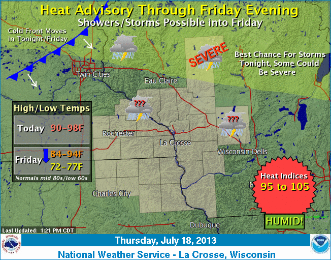
Thunderstorms waiting to ignite but cool front coming into view

Temperatures climbed into the lower 90s as far north as Duluth this afternoon. Heat index readings were in the upper 90s to near 100 in the late afternoon across much of the region.
Powerful thunderstorms are expected to erupt along a cool front in northeast Minnesota this evening and then track southeast.
The Storm Prediction Center (SPC) is highlighting an area that includes Duluth for the potential of damaging winds and large hail.
From SPC:
Create a More Connected Minnesota
MPR News is your trusted resource for the news you need. With your support, MPR News brings accessible, courageous journalism and authentic conversation to everyone - free of paywalls and barriers. Your gift makes a difference.
THE NWS STORM PREDICTION CENTER IN NORMAN OK IS FORECASTING THE
DEVELOPMENT OF DAMAGING WINDS AND LARGE HAIL OVER PARTS OF THE UPPER MIDWEST AND THE UPPER GREAT LAKES REGION THIS AFTERNOON AND TONIGHT.
THE AREAS MOST LIKELY TO EXPERIENCE THIS ACTIVITY INCLUDE
NORTHERN MINNESOTA
NORTHERN WISCONSIN


You can track the storm reports from Duluth from this web link.
Thunderstorms may lose some punch as they move toward the Twin Cities tonight. The best chance for storms in central Minnesota will be later tonight and early Friday.
Another day of heat and humidity is in store for southeast Minnesota and southwest Wisconsin on Friday. Temperatures will be several degrees cooler in northern Minnesota and northwest Wisconsin on Friday afternoon. You will notice the lower dew points on Friday night.
High temperatures on Saturday are expected to come up short of the seasonal normals. The normal high in the Twin Cities is 84 degrees for the 21st of July.

The cooler air will not push much into the Dakotas before stalling out on Saturday. A return push of warmer air could trigger more thunderstorms Saturday night and Sunday, particularly in central Minnesota.
