
Warm front ahead
Go Deeper.
Create an account or log in to save stories.
Like this?
Thanks for liking this story! We have added it to a list of your favorite stories.


The next few days will offer a return to warmer weather in Minnesota. A midweek warm front is pushing north, bringing warmer air and a chance for a few showers.
The heaviest rains will fall south of Minnesota, in Iowa and Missouri. Some of the moisture plume from Tropical Storm Ingrid in Mexico will get caught up in a southerly flow and may offer an injection of moisture into the Central Plains later this week.
Here's the seven-day rainfall forecast from the National Oceanic and Atmospheric Administration's Weather Prediction Center.

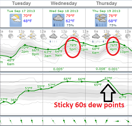
Our short term forecast features a warm front moving north Wednesday. There is a chance of a few stray showers with the front Tuesday night into Wednesday morning, then again with a trailing cool front Thursday. Temps will return to near 80 degrees Wednesday and Thursday in the metro.
Turn Up Your Support
MPR News helps you turn down the noise and build shared understanding. Turn up your support for this public resource and keep trusted journalism accessible to all.
You'll notice More humidity in the air as dew points climb back into the upper 60s. Here's the European Centre for Medium-Range Weather Forecasts model output for the next few days.
Frosty start up north
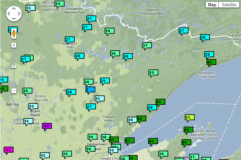
Monday morning featured the most widespread frost and freeze so far this season. The center of high pressure passed right overhead, and that's the perfect atmospheric condition for frost and freeze.
Many spots in northeast Minnesota plunged into the 20s this morning, with 30s just north of the metro. The coldest spot? Tiny Brimson dipped to 23 degrees. Here's a look at lows from NOAA's Mesonet.
Warm September continues
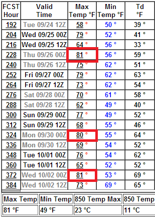
The bigger picture for Minnesota favors warmer than average temps for the rest of the month, and possibly into the first days of October. So far temperatures are running 5.3 degrees above average this month at Minneapolis-St. Paul International Airport.
Here's the NOAA Global Forecast System model output out to 16 days. It appears we still have plenty of days in the 70s to near 80 degrees ahead.
It's nice to see September give us back a little of the warmth we lost in May and early June.

