Seasonably mild; another sloppy system misses Minnesota
Relatively mild air riding over the icy landscape induced fog and low clouds to form last night. Temperatures held fairly steady overnight and have risen nicely into the 30s in some places. At 4 p.m it was 34 degrees at Montevideo, Minn., and Dodge Center, Minn.
Dense fog was hampering travel in some locations. The visibility was down to a quarter mile at Alexandria, Minn., at 4 p.m.
Another soggy weather system is already dumping generous rainfall on the area that received heavy snow on Sunday. This swath of precipitation will run into colder air is it advances north into Wisconsin.

Here's a National Weather Service map forecasting snow and rain accumulation over the next seven days. Note the heaviest precipitation in the Pacific Northwest, along the Gulf Coast and on the east coast of the United States.
Create a More Connected Minnesota
MPR News is your trusted resource for the news you need. With your support, MPR News brings accessible, courageous journalism and authentic conversation to everyone - free of paywalls and barriers. Your gift makes a difference.

A surface low will track on a path that is likely to keep the precipitation wet snow and sleet in parts of central Wisconsin tonight. A freezing rain advisory is in effect for Milwaukee, Wis., overnight.
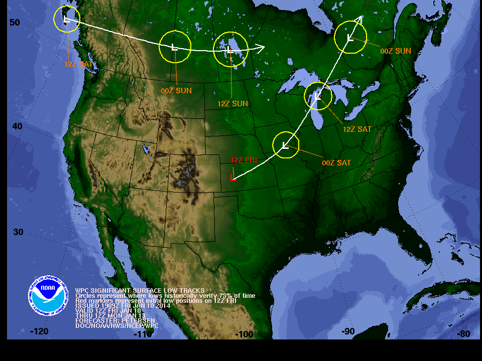
The most likely area to receive around four inches of snow is through central Wisconsin into upper Michigan.


The upper Midwest is likely to experience a flow from Alberta, Canada with only minor weather systems moving through our region in the next few days. So it appears the snow drought will continue for much of Minnesota.
For a snowfall comparison: Indianapolis, Ind., has tallied 27 inches of snow since Dec. 1, while the Minneapolis-St. Paul International Airport has measured a mere 16.2 inches of snow.
We have come up a little shy on moisture in some regions of the state this winter. A lack of moisture is a concern. A mid-winter drought in Minnesota typically doesn't have much of an impact at this time of year. Let's see what the rest of winter and early spring deliver with regard to precipitation.

Saturday looks to be a good day to get out and partake in outdoor activities. Temperatures will be a few degrees about the normal for this time of year.
Fort Snelling is hosting a National Winter Trails Day event beginning at 11 a.m. on Saturday. The Minnesota Department of Natural Resources says it's the "perfect opportunity for anyone new to snow sports to try snowshoeing, cross-country skiing, geocaching and other outdoor winter activities."
The mercury is expected to go above the thawing mark on Sunday, so there might be some melting taking place.

A bit of a breeze shouldn't lower the wind chills too drastically Sunday afternoon.

It is risky to peer too far into the future of the weather world this time of year, but the Global Forecast System Model paints a chilly morning a week from today.
