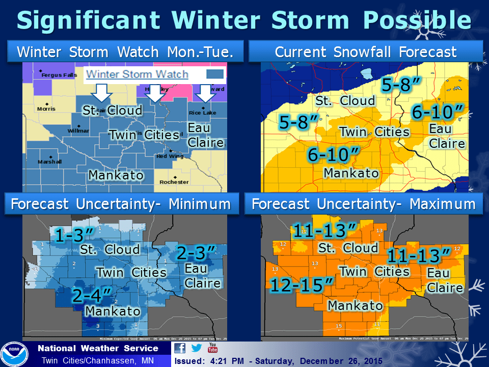
Winter storm watch Monday: Heavy snow totals likely
Our weekend snowfall was just the opening act. The main feature plays Monday afternoon.

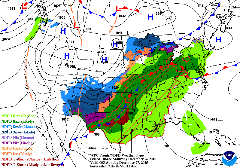
An even more powerful weather system winds up along the Texas coast Sunday, then makes a beeline almost due north for Minnesota. Heavy snow should arrive in southern Minnesota again by Monday morning, and push into the Twin Cities Monday afternoon.
Winter Storm Watch Monday
Create a More Connected Minnesota
MPR News is your trusted resource for the news you need. With your support, MPR News brings accessible, courageous journalism and authentic conversation to everyone - free of paywalls and barriers. Your gift makes a difference.
Winter storm watches are already up for much of Minnesota for Monday including the Twin Cities metro.

INCLUDING THE CITIES OF...ST. CLOUD...ELK RIVER...CAMBRIDGE... CENTER CITY...MONTEVIDEO...WILLMAR...LITCHFIELD...MONTICELLO... MINNEAPOLIS...BLAINE...ST. PAUL...STILLWATER...GRANITE FALLS...OLIVIA...HUTCHINSON...GAYLORD...CHASKA...SHAKOPEE...HASTINGS...
REDWOOD FALLS...NEW ULM...ST. PETER...LE SUEUR...FARIBAULT... RED WING...ST. JAMES...MANKATO...WASECA...OWATONNA...FAIRMONT...BLUE EARTH...ALBERT LEA...OSCEOLA...RICE LAKE...LADYSMITH...HUDSON...PRESCOTT...MENOMONIE...DURAND...CHIPPEWA FALLS...
EAU CLAIRE
305 PM CST SAT DEC 26 2015
...WINTER STORM WATCH IN EFFECT FROM MONDAY AFTERNOON THROUGH LATE MONDAY NIGHT...
THE NATIONAL WEATHER SERVICE IN TWIN CITIES/CHANHASSEN HAS ISSUED A WINTER STORM WATCH...WHICH IS IN EFFECT FROM MONDAY AFTERNOON THROUGH LATE MONDAY NIGHT.
* TIMING...MONDAY AFTERNOON INTO DAYBREAK TUESDAY.
* MAIN IMPACT...SNOWFALL ACCUMULATIONS OF 6 TO 10 INCHES.
Gulf Storm
We call these "Gulf storms" because they dive down to almost the Gulf of Mexico and suck up high amounts of Gulf moisture. These extremely wet storms can produce some of the heaviest wettest snowfalls of the winter in Minnesota. The infamous Halloween Mega-Storm was a Gulf storm. Nobody is forecasting that kind of snowfall with this system, but the tracks are similar.
The forecast models are very aggressive with snowfall totals early on. This seems reasonable given the likelihood of all snow, with copious amounts of moisture. Right now Monday PM and Tuesday AM rush hours will likely have the highest impacts.
It's still too early to be specific about snowfall totals for any one spot, but the possibility of 6" to 12" totals with this storm across parts of Minnesota are very plausible at this point.

Stay tuned, and be ready for the potential for heavy snow Monday afternoon into Tuesday morning.